Steep, Hampshire
| Steep | |
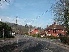 Steep village centre during winter |
|
 Steep |
|
| Population | 849 |
|---|---|
| OS grid reference | SU746253 |
| Civil parish | Steep |
| District | East Hampshire |
| Shire county | Hampshire |
| Region | South East |
| Country | England |
| Sovereign state | United Kingdom |
| Post town | Petersfield |
| Police | Hampshire |
| Fire | Hampshire |
| Ambulance | South Central |
| EU Parliament | South East England |
| UK Parliament | East Hampshire |
Coordinates: 51°01′23″N 0°56′42″W / 51.023°N 0.945°W
Steep is a village and civil parish in the East Hampshire district of Hampshire, England. Its nearest town is Petersfield, which lies 1.4 miles (2.3 km) south of the village, just off the A3 road. The nearest railway station is Petersfield, at 1.6 miles (2.6 km) south of the village. It has two public houses, The Harrow and the Cricketers Inn, with the former being an 18th-century Grade II listed building. According to the 2011 census, it had a population of 849.
Iron Age and Roman remains have been found in the area. Steep formerly included a detached parish enclave called Ambersham, which lies deeply in West Sussex. It was the only detached part of Hampshire and was returned to West Sussex when a new law came into effect in 1844. The church of All Saints was built around 1125. From medieval times, Steep was included in the parish of East Meon until it became an independent parish in 1867. Since 1899 the village has been the location of Bedales School, a progressive public school.
History
Prehistory to Roman
The village name has been spelled in various ways, including La Stuppe, La Stiepe, and Stupe (14th century) and Steepe (17th century).[1] There is evidence of Roman occupation in the village, with pottery, coins, baths and a Roman villa[2] being discovered on Bell Hill, directly opposite the village centre.[3] A Roman earthworks ridge was also found on Stoner Hill, which suggests evidence of Roman roads passing through the causeway.[3] Iron Age remains found in the area include pottery, boilers, and a site of a "sub-rectangular enclosure" found in Steep village centre. A Bronze Age barrow house was also excavated in the parish.[3]
Medieval to Tudor
The village was not mentioned in the Domesday Survey of 1086, however it was likely included under the entry of 'Menes'.[1] Beginning at an unknown point in the medieval period, the village of Steep formerly included a detached parish enclave called Ambersham, which lies 10.3 miles (16.6 km) east in the county of West Sussex, situated near Midhurst and Petworth. Under the Counties Act of 1844, Ambersham was detached from Steep and became part of West Sussex. For ecclesiastical reasons, it was split into two individual settlements; North Ambersham and South Ambersham, with the former being annexed to Fernhurst and the latter to Easebourne.[1]
Steep was not likely settled until late in the Anglo-Saxon period when it was first documented under the name of 'Stepe Place' in the 12th century. The church of All Saints was built around 1125, and the oldest surviving dwelling in the village dates from the late 16th century, which lies opposite the church.[2] In the early medieval period, Steep was included as a 'sub-parish' of East Meon.[1][2]
By 1600, Steep had a prospering local cloth-making industry and two fulling mills in operation, which were driven by the nearby Ashford Stream. The early 17th century was also described by historian William Page as a "great rebuilding" of the village, in which redevelopment of many wooden buildings were replaced by stone structures.[2] However, a decline in the cloth-making industry caused a depression in the latter half of the 17th century, which resulted in the closure of both mills.[2][1]
19th century to Second World War
By the 1830s the British Agricultural Revolution had disturbed traditional society and created a class of labourers who struggled to support their families in rural areas. This led to an unrest known as the Swing riots which swept across southern England, consequently reaching Selborne and Liphook in September 1830.[2] The Parliamentary Enclosure Acts of 1856 established a new land pattern for nearby Steep Marsh and Stroud, which still exists today. There was also extensive land drainage between 1860 and 1880; conduits and sluices were constructed to take water from Ashford Stream for the artificial flooding of hay meadows. In Steep, hops were grown for use in local breweries, watercress produced for commercial use, and a condensed milk factory was in operation in Steep Marsh.[2]
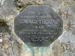
Voluntary schools were built in Steep in 1875, and the first almshouses were constructed by William Eames in 1882.[1] Bedales School was constructed in 1899 at a cost of approximately £60,000, which at the time of 1912, had an enrolment of 160 children.[1] However, another source described the school as being constructed in 1900, and was formerly located in Lindfield, West Sussex.[2] The First World War poet Edward Thomas lived in the village; his children attended Bedales School and his wife also taught there.[4]
Geography and demographics
Steep is located in the eastern part of southern Hampshire in South East England, 1.4 miles (2.3 km) north of Petersfield, its nearest town. The parish covers an area of 2,658 acres (1,076 ha), of which 1,222 acres (495 ha) are permanent grass, 443.7 acres (179.6 ha) of fertile land and 233 acres (94 ha) of woodland.[1] The village is situated at the foot of the steep forested slopes of Stoner Hill and Wheatham Hill, which both lie on the western edge of the South Downs National Park.[1][2] The parish has two streams; the first stream rises from Ashford Lodge and flows east to Steep Marsh, whereas a second stream rises at the foot of Wheatham Hill follows the northern boundaries of the parish, joining the first stream close to the village of Sheet. Two main roads run through the parish, from Petersfield to Farnham on the east and the Petersfield and Ropley road on the southwest, the latter winding up the steep slopes of Stoner Hill.[1]
The soil is of marl, clay, and sandy loam, with the subsoil being gravel and sand. The prominent crops are wheat, barley, and oats, and a smaller number of hops.[1] According to the 2011 census, Steep had a population of 849 people.[5]
Notable landmarks
The church of All Saints was first constructed in the 12th century and has some parts which still date to its original design.[4] It has a chancel that measures 16 feet (4.9 m) by 13 feet (4.0 m), a nave which measures 50 feet (15 m) by 16 feet (4.9 m) and north and south aisles which run from 13 feet (4.0 m) to 5 feet (1.5 m) wide, respectively. The eastern bays of the south arcade of the nave date from 1180; however, it seems probable that the oldest masonry on the site belongs to an older church from either Colemore or Ropley.[1] Before the north aisle was constructed, there is evidence to suggest that a wooden north-west tower existed.[1]
In approximately 1200 a north aisle was added, with its width being determined by the projection of the north transept chapel, with the west and east walls taken down at the time. The different thickness of the walls in the present church suggests that the wall for the length of the first three bays of the arcade was taken down and rebuilt in the 13th century. The church underwent a restoration in 1839, with £370 being spent, and in 1875 at a cost of £2,377.[1]
The churchyard contains six Commonwealth war graves from World War I - two Royal Navy sailors, two Royal Air Force officers, a Royal Engineers officer and a Hampshire Regiment soldier.[6]
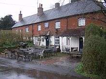
The Harrow is a Grade II listed public house which was first built in the 18th century.[7] It is on the Campaign for Real Ale's National Inventory of Historic Pub Interiors.[8]
References
- 1 2 3 4 5 6 7 8 9 10 11 12 13 14 Page, William (1908). "History of Steep". British History Online. pp. 77–81. Retrieved 13 December 2015.
- 1 2 3 4 5 6 7 8 9 "Steep Parish Plan" (PDF). Steep Village Website. Hampshire County Council. 2012. Retrieved 16 December 2015.
- 1 2 3 "British Archaeological Sites in Steep". Archaeology UK. Retrieved 13 December 2015.
- 1 2 "Hampshire Treasures: Steep". Hampshire County Council. p. 301. Retrieved 15 December 2015.
- ↑ "Steep population figures". City Population. Thomas Brinkoff. Retrieved 13 December 2015.
- ↑ CWGC Cemetery Report, details from casualty record.
- ↑ Historic England, "The Harrow, Steep (1253271)", National Heritage List for England, retrieved 20 August 2014
- ↑ Brandwood, Geoff (2013). Britain's best real heritage pubs. St. Albans: CAMRA. p. 45. ISBN 9781852493042.
