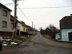
Rozdrojovice
| Rozdrojovice | |||
|---|---|---|---|
| Municipality | |||
 | |||
| |||
 Rozdrojovice | |||
| Coordinates: 49°15′17″N 16°30′31″E / 49.25472°N 16.50861°ECoordinates: 49°15′17″N 16°30′31″E / 49.25472°N 16.50861°E | |||
| Country |
| ||
| Region | South Moravian | ||
| District | Brno-Country | ||
| Area | |||
| • Total | 2.82 km2 (1.09 sq mi) | ||
| Elevation | 304 m (997 ft) | ||
| Population (1.1.2012) | |||
| • Total | 895 | ||
| • Density | 320/km2 (820/sq mi) | ||
| Postal code | 664 34 | ||
Rozdrojovice is a village and municipality (obec) in Brno-Country District in the South Moravian Region of the Czech Republic.
The municipality covers an area of 2.82 square kilometres (1.09 sq mi), and has a population of 721 (as at 3 July 2006).
Rozdrojovice lies approximately 10 kilometres (6 mi) north-west of Brno and 177 km (110 mi) south-east of Prague.
References
| Wikimedia Commons has media related to Rozdrojovice. |
This article is issued from Wikipedia - version of the 9/12/2016. The text is available under the Creative Commons Attribution/Share Alike but additional terms may apply for the media files.