Rydalmere, New South Wales
| Rydalmere Sydney, New South Wales | |||||||||||||
|---|---|---|---|---|---|---|---|---|---|---|---|---|---|
 The Family Inn, Victoria Road | |||||||||||||
| Population | 6,216 (2011 census)[1] | ||||||||||||
| • Density | 3,035.3/km2 (7,861.4/sq mi) | ||||||||||||
| Established | 1856 | ||||||||||||
| Postcode(s) | 2116 | ||||||||||||
| Area | 2.0479 km2 (0.8 sq mi) | ||||||||||||
| Location | 21 km (13 mi) north-west of Sydney CBD | ||||||||||||
| LGA(s) | City of Parramatta | ||||||||||||
| County | Cumberland | ||||||||||||
| State electorate(s) | Parramatta | ||||||||||||
| Federal Division(s) | Parramatta | ||||||||||||
| |||||||||||||
Rydalmere is a suburb of Sydney, in the state of New South Wales, Australia. Rydalmere is approximately 21 kilometres north-west of the Sydney central business district in the local government area of the City of Parramatta.
History
The earliest grant in the area was to Phillip Schaeffer who settled in 1791. The district comprising modern day Rydalmere, Ermington and Dundas was initially called "The Ponds" because of such natural features occurring above Subiaco Creek. Shortly after Schaeffer's, further grants were given to several emancipists, eight marines and two crew of HMS Sirius, on the northern bank of the Parramatta River at Rydalmere and Ermington. By about 1800 "The Ponds" became known as "Field of Mars". Presumably because of Mars being the god of war, and the military men that received land grants there. The parish of Field of Mars spread more or less from Parramatta to West Ryde and up to Carlingford and Eastwood. Later on to the north of this area along the Lane Cove river, a Field of Mars Common of 5000 acres was established. Today's Field of Mars reserve and cemetery are remnants of this common. Rydalmere was named by Thomas O'Neill when he purchased much of the 600 acres of Hannibal Macarthur's old Vineyard Estate, after it was put up for sale through the trustees by the Catholic church in 1877. Despite the myth surrounding O’Neill coming from England’s Cumbrian Lake District, he was born in Tipperary, Ireland in 1830, and accompanied his parents to Australia as a young lad, where he finished his education. He left for the Californian goldfields in 1849 and returned in 1851, the venture being quite profitable for him. He entered business with much energy and a strong drive which along with sound commercial instincts allowed him to retire a very wealthy man in 1877. Another myth is that O'Neill purchased the Vineyard estate as a speculator in order to quickly sell it and make a healthy profit. The facts don't tend to support this view. After the purchase, he established his "Fairmount Estate" which covered a considerable portion of Rydalmere, the boundaries more or less extending from Park Road (formerly Wharf St) to Spurway Street, the southern boundary being the Parramatta river, and the northern boundary being Subiaco Creek (formerly Bishop’s Creek). It was an orchard and pasture property "Fairmount" the family home he built, was said to be a very beautiful residence, and splendid views were to be had from its tower. It has long since disappeared and was thought to have been located near Victoria Road and Gammel St. The property sales and sub-divisions only occurred slowly, and appear to be a result of either being required for the advancement of the suburb, or the estate being divided over time by roads being established i.e. Victoria Road in 1886, rather than being sold off for a profit. Thomas O'Neill died on 13 March 1890 at Fairmount aged 59. His funeral service was held in St Mary's Cathedral, and he was buried in Waverley cemetery. He was said to have been a most amiable man, held in high regard by all that knew him. His was deeply involved in not only Irish and Catholic affairs, but public affairs in general. His charity spanned many years with his support of St Vincent's Hospital, The Good Samaritan Refuge and The Benevolent Asylum being on-going. His purse was never closed to charity. His final act before his illness was to donate the land and money to help the establishment of the Catholic church and school at Rydalmere. He still owned most of his Rydalmere property at the time of his death. Fairmount was later sold by the family and remained an orchard with a few building lots sold. It was not until after WW11, when the Housing Commission acquired it for public housing, that it was fully developed. So why did he name his property Rydalmere, a lake he probably had never seen? Well, he had owned an estate named Rydalmere, which he had sold years before buying the Vineyard estate and must have liked the name which he reused. Exactly where his first Rydalmere property was located is not known. Rydalmere is a lake in The English Lake District which gains its name from the nearby village of Rydal. Mere is an Old English word meaning "lake", or "body of water".[2]
Aboriginal culture
The Darug is the clan name for the indigenous people of the area. The Darug fashioned tools and spears for hunting native animals and collected wild berries and flora as a valuable source of vitamins. The Darug had a close relationship with the river, from which they caught fish, eels, and other food. Their stable bark canoes often carried a small fire in the middle — built on a mound of soil to allow them to cook their catch fresh. 'Firebrand farming' was also practised in the region.
European settlement
Soon after Governor Phillip's arrival with the First Fleet (of convicts from England) in 1788, Parramatta was developed as a farming settlement to feed the new English colony. This led to the immediate and tragic displacement of local Aborigines from the land they had lived off for thousands of years.
Local Aboriginal groups led a resistance against the new settlers. The most prominent warrior was Pemulwuy. Once when he tried to spear a soldier in retaliation, he was shot in the head and body. Despite being held in chains in the hospital where he was sent to recover, he managed to escape. In retaliation, the British ordered that any groups of Darug Aborigines be attacked, and a reward was placed on Pemulwuy's head. In 1802 he was shot and killed, and his head was cut off and sent to England. The conflict continued on and off until 1805 when the first recorded act of reconciliation occurred between Indigenous people and the British settlers.
The introduction of foreign diseases was the most debilitating trend — and many of the Barramatagal clan disappeared in the Small Pox epidemic during early European settlement. However against the odds others survived and their descendants live in the region to this day. In the early 19th century, more positive developments occurred and the region became a meeting place for tribes from surrounding regions. An annual feast was held by Governor Macquarie to encourage Aboriginal people to leave their children at a local school, but this focus later shifted to Blacktown area.[3]
Transport


Rydalmere railway station is located on the Carlingford line of the Sydney Trains network. The next station to the south is Camellia and to the north is Dundas. A conversion of the Camellia to Carlingford section of the Carlingford railway line to light rail was announced in 2015 as part of the Parramatta Light Rail project.[4]
Rydalmere ferry wharf is on Parramatta River and has services run by the Sydney Ferries network. The next wharf west is at Parramatta and east is Meadowbank. The ferry primarily services tourists on weekends and city workers during the week. RiverCat catamaran type ferries work the Parramatta River route due to shallow waters, particularly during low tides.
There are five Sydney bus routes that service the area— the 520/M52 travels to and from Parramatta Station to City and Circular Quay. The 523 travels via Spurway and Bartlett Streets in Ermington and on to West Ryde. The 524 services the industrial area of Rydalmere stopping along South Street and then on to the south side of Ermington and Melrose Park. The 525 is a Parramatta Station to Burwood service. All routes travel along Victoria Road at some point and stop at Rydalmere Station.
In the 2001 census, for people travelling to work using just one method of transportation from Rydalmere, 54% travelled in a car as the driver, 6% took the train, 5% walked, 4% travelled in a car as passenger, 4% took the bus. Commuting to work via ferry, truck, motorbike, bicycle accounted for only 1% each of the Rydalmere population.
Commercial areas
Rydalmere currently consists of residential and commercial developments. The western side of Rydalmere is commercial consisting primarily of light manufacturing industry and service industries. The eastern side is mainly residential.
Rydalmere Family Inn
In 1886 Thomas O’Neill advertised land on the "Rydalmere" estate. The subdivision was divided into residential blocks, and was bounded by Victoria and Park Roads, and included Pine, Wattle and Myrtle Streets. The sale was hardly a success, though the corner block of Victoria & Park was sold, with building probably commencing that year, and the hotel license being obtained to allow the opening of the “Rydalmere Family Hotel”. O’Neill donated the neighboring land to the Catholic Church and school, while the rest of that subdivision appears to have been purchased by Frederick Randall, the Postmaster. It was known as Randall’s Estate and sold some 30 years later. The Rydalmere Hotel has a long if interrupted history. Henry Atkins was the first Licensee, but only held it for a short time before transferring the license to Henry Jenkins in March 1887.[5] Mr. Jenkins wasted no time advertising his hotel in the SMH, with the Saturday 26 March edition extolling the virtues to "City Gentleman and Families" of the "comfort and moderate charges at the RYDALMERE FAMILY HOTEL, which is in every sense a country hotel". Disaster struck when Sydney was hit by a storm with gale force winds on Friday 23 September 1892, resulting in the hotel being blown down.[6] There was even greater excitement in the district on 9 September 1907, when Constable Howard, senior officer of the Dundas district described how he passed through the scrub near the Rydalmere Hotel shortly after mid-day. He inspected the hotel, where everything appeared ok, but then he heard noises and talk coming from the Catholic Church next-door, indicating illegal drinking taking place. Waiting at the door, he attempted to detain a person as they were leaving, but was dragged into the building where he received a fearful beating and kicking from four men. He drew his revolver and fired, wounding a man. The four men arrested were Thomas Millane (the wounded Licensee of the Rydalmere Hotel), Michael Millane (his brother), Michael Murphy (caretaker of the church) and George Workman. The hotel continued trading with a somewhat dubious reputation and ever changing Licensees until 1929, when it was forced to close due to its license being transferred to a Campsie hotel. In 1949 Millers applied to re-license the Rydalmere hotel by transferring the license of the New Langham Hotel in York Street. The Rydalmere Family Hotel was renovated, and additions made to it, so that it was ready for its official opening on 31 December 1949.[7] It is an unusual design, with the double story section on the eastern side possibly being the original 1892 building, built after the storm. It had a striking appearance of off white, with the lower section having light blue glazed tiles with black tile trim. A cool colour scheme, which on hot days beckons its customers, and very different to the brown tiles of most pubs at the time. During the 70s the colour changed, as did the name, to The Family Inn and it became one of Sydney's leading live music venues.
Rydalmere Shopping Centre
The shopping centre is located on both sides of Victoria Road at the intersection with Park Road. The northern side was constructed in 1959 and is typical of the era. The original shops consisted of Strange's Four Square Food Store, Davy's Pharmacy, McLeay's Hardware, Lorna Beauty Salon, Bambino Children's & Baby Wear, Rydalmere Fish Supply, Rydalmere Milk Bar and Pat Howard Barber & Tobacconist. A weatherboard Post Office building originally stood near the footpath on Victoria Road, but was relocated back near the bank adjacent to the shops in the early 60s. The shops formerly located on the southern side of Victoria Road were built about the same time and belonged originally to the Hellyer family. They are the Newsagency and Grocery/Milk Bar. The end shop nearest Park Road was a Fish Shop/Takeaway that traded for a great many years as The White Rose. They were demolished in 2010 to make way for Aldi's new store.
Lost heritage
Rydalmere lost the beautiful Subiaco in 1961; it was formerly the home of Hannibal Macarthur, owner of the Vineyard Estate. Factories had surrounded the property. Rheem (Aust) acquired and demolished the property in order to extend their factory. The house itself was a great loss, but the convent grounds had become a time capsule and still included Hannibal Macarthur’s original garden and Phillip Schaeffer's earlier house "Vineyard" c1791. In contrast and a kilometre or so downstream, International Combustion Australia (ICA) had acquired the old Truganini Park property in 1953, in order to erect their new factory on the corner of South Street and Park Road. The old homestead "Truganini" was still in good condition, so ICA preserved it by building their new factory around it, and using it as office space. The factory was sold and demolished and is now a factory unit complex but Truganini is still there thanks to 60 years of careful maintenance by ICA. Although it is a private business premises, its exterior can be viewed by anyone interested during business hours. Another sad loss was the old original brick school building on Victoria Road, a typical 2 room country schoolhouse of the period. The Minister for Public Instruction opened it with much ceremony on 14 December 1890. On completion of these duties, the official party hurriedly made their way across the road in order to perform a similar duty for the opening of the Rydalmere School of Arts. The old school building had been used as the school library for many years and suffered damage from a fire out of school hours. Being the 1960s, it would be reasonable to suggest that demolition rather than preservation was the first thought that entered the mind of the bureaucrat making the decision. Thankfully the "Masters House" built at the same time as the school, and located next-door still exists. It is now a private dwelling. Although the Ermington-Rydalmere local Council was absorbed into Parramatta Council in 1948, the old Town Hall managed to survive until 1963 before it was demolished. Erected in 1889, it was a hall with a classical style façade and stood near the footpath, facing Victoria Road. What is now John Carver Reserve was the "Town Hall Green" so to speak. A little further up the footpath on the eastern side, stood the old wooden "temporary" Post Office. It was demolished about 1962 along with the old neighboring Fire Station. Across the road on the south east side of Park Road, near the corner of Victoria Road stood the old horse trough. It went about the same time. In the sixties, if something was old, and stood still, it was fair game.
Housing
The residential part of Rydalmere is divided by Victoria Road. The northern side has generally higher property prices and less Department of Housing and this is reflected in the more conservative voting pattern.[8]
- Property Prices, 12 months to 1/March/2006.
- Houses Average: $461,000.
- Houses Median: $448,000.
- Median change over last 12 months: -6%.
- Units Average for postcode: $377,000.
- Based on sales reported to Australian Property Monitors[9]
Landmarks
- Holy Name of Mary Roman Catholic Church
- Female Orphan School
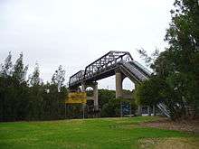
- Waterpipe and Pedestrian Bridge over Parramatta River
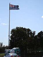
- Big Flagpole at Berlei factory on South Street
- Rydalmere Bowling Club
- Subiaco Creek
- Vineyard Creek
Schools
- Rydalmere Public School
- University of Western Sydney "Parramatta" Campus
- St Marys Catholic School
Parks
- Crowgey Street Reserve
- Eric Primrose Reserve
- John Carver Reserve
- Rydalmere Park
- Rydalmere section of Parramatta to Putney cycleway
- Rydalmere section of Parramatta River
- Schaeffer Park (mostly closed due to bunnings construction 2012)
Organisations
- Rydalmere Bowling Club
- Rydalmere Cricket Club
- Rotary Club of Rydalmere
- Rydalmere Branch of Australian Labor Party
- 1st Rydalmere Scout Group
- Part of the suburb of Rydalmere lies in the Anglican parish of Dundas/Telopea.[10]
Sport and recreation
- The Rydalmere Cricket Club's team, 'The Mighty Wrens',[11] plays in the Northern Districts Cricket Association (NDCA [12] competition.The Rydalmere and Dundas United Cricket Clubs are a partnership that involves the Rydalmere Cricket Club being responsible for senior cricket teams and Dundas United Cricket Club responsible for developing and fostering junior cricket in the greater Parramatta area.
- Parramatta City FC Blues is the soccer (football) team whose home ground is Eric Primrose Reserve in Rydalmere.
Population
At the 2011 census, Rydalmere recorded a population of 6,216. Of these:[1]
- The age distribution was quite similar to the country in general. The median age was 37 years, identical to the national median. Children aged 0–14 years made up 21.2% of the population (national average is 19.3%) and people aged 65 years and over made up only 12.0% of the population (national average is 14.0%).
- Just over half (58.5%) were born in Australia; the next most common countries of birth were China 9.4%, Korea 4.5%, Hong Kong 2.2%, England 2.0% and Philippines 1.7%. The breakdown of languages spoken at home is similar: 53.2% spoke English, and other languages spoken at home included Mandarin 7.7%, Cantonese 7.2%, Korean 6.0%, Arabic 2.8% and Spanish 1.4%.
- The average household weekly income was $1,287, which is very similar to the national average of $1,234.
- Only 17.4% of employed people travelled to work on public transport, and 65.7% by car (either as driver or as passenger).
Politics
In the Australian Parliament, Rydalmere falls within the Division of Parramatta, currently represented by Julie Owens,[13] a member of the Australian Labor Party. Owens was elected at the 2004 federal election.
In the New South Wales Parliament, Rydalmere falls within the Parramatta electorate, currently represented by Geoff Lee,[14] a member of the Liberal Party. Lee was elected to NSW Parliament at the 2011 state election.
Rydalmere falls within the Elizabeth Macarthur Ward of the City of Parramatta local government area.[15]
References
- 1 2 Australian Bureau of Statistics (31 October 2012). "Rydalmere(NSW)". 2011 Census QuickStats. Retrieved 13 April 2014.
- ↑ "OBITUARY The Late Thomas O'Neill". Freeman's Journal Saturday 22 March 1890. page 14
- ↑ The Book of Sydney Suburbs, Compiled by Frances Pollon, Angus & Robertson Publishers, 1990, Published in Australia ISBN 0-207-14495-8, page 233
- ↑ "Parramatta Light Rail - How the preferred network was chosen". Transport for NSW. Retrieved 8 December 2015.
- ↑ SMH Tuesday 22 March 1887 Page 4.
- ↑ "Fearful Storms in Sydney". National Advocate (Bathurst) Monday 26 September 1892 Page 2.
- ↑ Cumberland Argus & Fruitgrowers Advocate Wednesday 17 August 1949 Page 2.
- ↑ http://www.seo.nsw.gov.au/electoral_districts_menu/district_index/Results_parramatta_3565.html
- ↑ http://www.domain.com.au/Public/SuburbReport.aspx?searchTerm=2116&mode=
- ↑ "Dundas Telopea Anglican Church".
- ↑ "Home". Cricket NSW. 2011-06-14. Retrieved 2011-08-02.
- ↑ "Home". Cricket NSW. 2011-06-14. Retrieved 2011-08-02.
- ↑ Dept of House of Representatives Web Manager (27 July 2011). "Parliament of Australia: House of Representatives". Aph.gov.au. Retrieved 2 August 2011.
- ↑ "Dr (Geoff) Geoffrey Lee, BAppSc(Hort), MBA, DBA MP". Members of the NSW Legislative Assembly. Parliament of New South Wales. 28 April 2011. Retrieved 30 April 2011.
- ↑ "PCC | Parramatta City Council". Parracity.nsw.gov.au. 26 July 2011. Retrieved 2 August 2011.
External links
| Wikimedia Commons has media related to Rydalmere, New South Wales. |
- Parramatta City Council.
- "Rydalmere". Dictionary of Sydney. 2008. Retrieved 29 September 2015. [CC-By-SA]
Coordinates: 33°48′40″S 151°02′08″E / 33.81111°S 151.03565°E