Ryde, New South Wales
| Ryde Sydney, New South Wales | |||||||||||||
|---|---|---|---|---|---|---|---|---|---|---|---|---|---|
 Ryde City Council Chambers | |||||||||||||
| Population | 21,599 (2011 census)[1] | ||||||||||||
| • Density | 3,042/km2 (7,880/sq mi) | ||||||||||||
| Postcode(s) | 2112 | ||||||||||||
| Area | 7.1 km2 (2.7 sq mi) | ||||||||||||
| Location | 13 km (8 mi) north-west of Sydney CBD | ||||||||||||
| LGA(s) | City of Ryde | ||||||||||||
| Region | Northern Suburbs | ||||||||||||
| State electorate(s) | |||||||||||||
| Federal Division(s) | Bennelong | ||||||||||||
| |||||||||||||
Ryde is a suburb of Sydney, New South Wales, Australia. Ryde is located 13 km north-west of the Sydney central business district and 8 km east of Parramatta. Ryde is the administrative centre of the local government area of the City of Ryde and part of the Northern Suburbs area. It lies on the north bank of the Parramatta River.
North Ryde, West Ryde, and East Ryde are separate suburbs from Ryde.
History
Ryde was named after the town of Ryde on the Isle of Wight. It may have been adopted from G.M. Pope, who came from Ryde on the Isle of Wight, who settled in the area and opened the 'Ryde Store'.[2]
Originally known by its Aboriginal name Wallumatta, the whole area between Parramatta and Lane Cove Rivers became known as the Field of Mars. The name Ryde was used from the 1840s and adopted as the name of the municipality in 1870. The suburb contains the oldest settler's cottage in Australia, Addington, on Victoria Road. Addington was built by the emancipist James Stewart, circa 1800. James Shepherd bought the property in 1810 and added a six-room house to the original sandstone cottage.[3] Addington House, also known as "New Farm", is included on the NSW Heritage Register and the National Trust of NSW.[4]
Other historic buildings in the area include the police station on Victoria Road and Willandra, Willandra Street. The police station, a simple sandstone structure, was designed by Colonial Architect Mortimer Lewis and built in 1837. Willandra is a two-storey Georgian home built by the Devlin family circa 1845, and more recently used as an art gallery and headquarters for the Ryde and District Historical Society. Both Willandra and the police station are listed on the Register of the National Estate.[5]
In 1892, the public school at 2 Tucker Street was opened. The building, which still survives, is the Infants Department, a two-storey, sandstone building which is heritage-listed.[6]
The cottage Riversdale, in Wade Street, was the home of a well-known riverboat captain by the name of Robert Gascoigne, who lived in the area circa 1900.[7]
As Ryde was located at the top of the hill it also became known as 'Top Ryde'. Ryde Swimming Centre was demolished and rebuilt as Ryde Aquatic Leisure Centre, and hosted events of the 2000 Olympics.
Trams
The majority of services operated from Fort Macquarie and Circular Quay down George St to Broadway and Parramatta Road. In the peak hours and other busy periods, supplementary services operated from Railway Square.
Tram services to Drummoyne and Ryde were serviced by the Rozelle Tram Depot. The service, after departing the depot travelled along the Crescent and Commercial Road (now City West Link Road) in Glebe, turning left onto Victoria Road. It then crossed the Iron Cove Bridge and the former Gladesville Bridge before turning right onto Blaxland Road. It then wound its way along Blaxland Road, behind the site of the current council chambers, terminating near the intersection of Pope and Devlin Street in Ryde.[8]
Commercial area
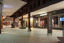
Top Ryde is an unofficial locality within Ryde, which contains the commercial area of the suburb, centred on the intersection of Devlin Street and Blaxland Road. Top Ryde City is a major shopping centre there. The original Top Ryde shopping centre on this site was the second of its type to be built in Australia.
Top Ryde is the location of the Ryde council office, and library.
2RRR is a community radio station in Sydney, Australia broadcasting to the Ryde area on 88.5 FM.
Transport
The Ryde Bridge links Ryde south to Rhodes, over the Parramatta River. Sydney Buses operate a number of services in Ryde including:
- M41 - Marsfield via Macquarie Park or Hurstville via Campsie
- M52 - Sydney CBD (limited stops) or Parramatta via Ermington
- 287 - Milsons Point via Lane Cove (Weekday AM peak service)
- 458 - Macquarie Centre or Burwood via Concord
- 459 - Macquarie Centre or Strathfield via Concord
- 500 - Sydney CBD via Rozelle
- 501 - Sydney CBD via Pyrmont or West Ryde
- 507 - Sydney CBD via Putney or Macquarie Centre via North Ryde
- 515 - Sydney CBD via Rozelle or Eastwood via Denistone
- 518 - Sydney CBD via Rozelle or Macquaire Centre via Denistone East
- 520 - Sydney CBD via Rozelle or Parramatta via Ermington
The main closest train station for the access to Ryde is West Ryde railway station which is on the North Shore, Northern & Western Line of the Sydney Trains network.
At the 2011 census, 20.5% of employed people travelled to work on public transport and 61.5% by car (either as driver or as passenger).[1]
Schools

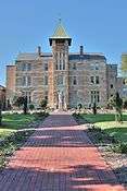
Schools in Ryde include government schools such as Ryde Secondary College (formerly Malvina High School) and Ryde Public School, Tucker Street, which is heritage-listed.[6] It also includes a few private schools such as Holy Cross College and Northcross Christian School. The German International School Sydney operated in Ryde from 1992 to 2008 and moved to Terrey Hills in August 2008. [9]
Places of worship
Ryde contains St Anne's Anglican Church, Church Street, which has the grave of Maria Ann Sherwood Smith, in whose orchards the Granny Smith apple was first found. Every year, in the suburb of Eastwood, the Granny Smith Festival is held in her honour. The church was built in 1826 and extended in later years. It was a central feature in the early life of the area and is now listed on the Register of the National Estate.[10] Church Street is also the location of Ryde Wesley Uniting Church.
Parks and recreation
Santa Rosa Park is located between Quarry Road and Bridge Road. It features a separated pathway for walking and bike riders. Shrimptons Creek runs through the park in a north-easterly direction flowing into the Lane Cove River. The park is used for football and cricket. Gannan Park was once a quarry and brickworks and is accessed from Buna Court, Minga Street and McAuley Park.
Ryde Pool was home to water polo events for the Sydney Olympics, held in 2000. The pool is now owned by Ryde City Council.
Population
Demographics
At the 2011 census, Ryde recorded a population of 21,599. Of these:[1]
- Age distribution
- The distribution of ages in Ryde was similar to the country as a whole. Ryde residents' median age was 37 years, identical to the national median. Children aged 0–14 years made up 17.6% of the population (national average is 19.3%) and people aged 65 years and over made up 15.5% of the population (national average is 14.0%).
- Ethnic diversity
- Just over half (55.8%) of residents were born in Australia; the next most common countries of birth were China 6.8%, Italy 2.7%, England 2.1%, South Korea 2.1% and India 2.0%. However, only 17.0% identify their ancestry as Australian, which is the largest group; the next most common self-identified ancestries were English 16.5%, Chinese 11.1%, Italian 7.9% and Irish 6.2%. Just over half (54.8%) of people only spoke English at home; other languages spoken at home included Mandarin 6.0%, Cantonese 5.0%, Italian 4.6%, Armenian 3.7% and Arabic 2.5%.
- Income
- The average weekly household income was $1,380, slightly above the national average of $1,234.
- Housing
- More than two-thirds (69.7%) of private dwellings were family households, 25.7% single person households and 4.6% group households. Stand-alone houses accounted for 54.5% of dwellings, while 33.1% were flats, units or apartments and just 12.2% were semi-detached.
Notable residents
- Bennelong - One of the most notable Indigenous Australians, who served as a link between the colony at Port Jackson and the Eora people, is buried in present-day Putney.
- Laura Forster - World War I surgeon and nurse who was born in Ryde.
- Karen Moras - Olympic bronze medallist in swimming and world record holder, was born in Ryde in 1954.
- John Robertson - Former Leader of the Australian Labor Party in New South Wales and the Leader of the Opposition from 2011 to 2014.
- Maria Ann Smith - Credited with producing the Granny Smith apple lived in Eastwood and is buried in Ryde.
- James Squire - Convict brewer, who is claimed to have created Australia's first commercial brewery.
- Hayden Turner - Zookeeper and TV presenter.
- John Watkins - The former Deputy Premier of NSW and Minister for Transport and Finance in NSW.
- Iggy Azalea - Australian rapper born in Ryde Hospital[11]
Ryde_Public_School_Infants_Section.jpg) Ryde Public School, Tucker Street
Ryde Public School, Tucker Street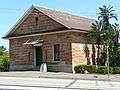 Police station (designed by Mortimer Lewis), Victoria Road
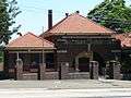 Court House, Victoria Road
heritage_home_Ryde.jpg) Addington cottage, circa 1800, Victoria Road
Addington cottage, circa 1800, Victoria Road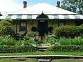 Riversdale, the former home of a Ryde riverboat captain
References
- 1 2 3 Australian Bureau of Statistics (31 October 2012). "Ryde (State Suburb)". 2011 Census QuickStats. Retrieved 27 October 2013.
- ↑ The Book of Sydney Suburbs, Compiled by Frances Pollon, Angus & Robertson Publishers, 1990, p.234 ISBN 0-207-14495-8
- ↑ Parramatta River Walk, Department of Planning, New South Wales, 1989, p.25
- ↑ "NSW heritage search - Addington House". NSW Department of Environment and Heritage. Retrieved 23 April 2014.
- ↑ The Heritage of Australia, Macmillan Company, 1981, p. 2/63
- 1 2 State Heritage Register
- ↑ Parramatta River Walk, Department of Planning, New South Wales, 1989, p.21
- ↑ Gregory's Street Directory, 1955, map 72, reference D-13. Map 26 Reference K-16
- ↑ http://www.germanschoolsydney.com
- ↑ The Heritage of Australia, p.2/63
- ↑ The birth of Iggy Azalea: How a schoolgirl named Amethyst clung to a dream to become a rapper, The Daily Telegraph, 23 August 2014
External links
| Wikimedia Commons has media related to Ryde, New South Wales. |
- Angela Phippen - Ryde Library (2008). "Ryde". Dictionary of Sydney. Retrieved 29 September 2015. [CC-By-SA]
Coordinates: 33°48′55″S 151°06′04″E / 33.81528°S 151.10111°E