Sørli
| Sørli herred | |
|---|---|
| Former Municipality | |
| Municipality ID | NO-1737 |
| Adm. Center | Sørli |
| Area[1] | |
| • Total | 1,435 km2 (554 sq mi) |
| Created from | Lierne in 1915 |
| Merged into | Lierne in 1964 |
| Sørli Mebygda | |
|---|---|
| Village | |
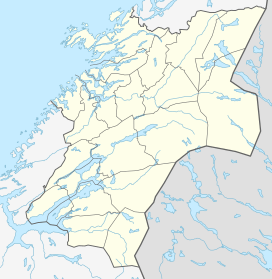 Sørli  Sørli Location in Nord-Trøndelag | |
| Coordinates: 64°13′26″N 13°49′57″E / 64.22389°N 13.83250°ECoordinates: 64°13′26″N 13°49′57″E / 64.22389°N 13.83250°E | |
| Country | Norway |
| Region | Trøndelag |
| County | Nord-Trøndelag |
| District | Namdalen |
| Municipality | Lierne |
| Elevation[2] | 372 m (1,220 ft) |
| Time zone | CET (UTC+01:00) |
| • Summer (DST) | CEST (UTC+02:00) |
| Post Code | 7884 Sørli |
Sørli is a village and former municipality in Nord-Trøndelag county, Norway. The village of Sørli (also known as Mebygda) lies on the southeastern shore of the lake Lenglingen. The main church for the area is Sørli Church.[1]
History
The municipality of Sørli established on 1 July 1915 when the old municipality of Lierne was split in two parts: Nordli and Sørli. The old municipality of Lierne was created on 1 January 1874 when it separated from Snåsa. Initially, Sørli had a population of 739. On 1 January 1964, Sørli and Nordli were reunited to once again form the municipality of Lierne. Prior to the merger, Sørli had a population of 898.[3]
References
- 1 2 Store norske leksikon. "Sørli. – kommune" (in Norwegian). Retrieved 2011-09-09.
- ↑ "Sørli" (in Norwegian). yr.no. Retrieved 2011-09-09.
- ↑ Jukvam, Dag (1999). "Historisk oversikt over endringer i kommune- og fylkesinndelingen" (PDF) (in Norwegian). Statistisk sentralbyrå.
This article is issued from Wikipedia - version of the 8/1/2016. The text is available under the Creative Commons Attribution/Share Alike but additional terms may apply for the media files.