Høylandet
| Høylandet kommune | |||
|---|---|---|---|
| Municipality | |||
|
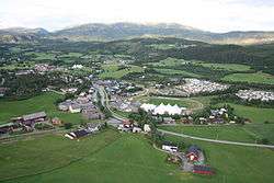
View of Høylandet village | |||
| |||
 Høylandet within Nord-Trøndelag | |||
| Coordinates: 64°43′27″N 12°20′2″E / 64.72417°N 12.33389°ECoordinates: 64°43′27″N 12°20′2″E / 64.72417°N 12.33389°E | |||
| Country | Norway | ||
| County | Nord-Trøndelag | ||
| District | Namdalen | ||
| Administrative centre | Høylandet | ||
| Government | |||
| • Mayor (1993) | Lars Otto Okstad (Sp) | ||
| Area | |||
| • Total | 754.39 km2 (291.27 sq mi) | ||
| • Land | 702.44 km2 (271.21 sq mi) | ||
| • Water | 51.95 km2 (20.06 sq mi) | ||
| Area rank | 144 in Norway | ||
| Population (2011) | |||
| • Total | 1,270 | ||
| • Rank | 389 in Norway | ||
| • Density | 1.8/km2 (5/sq mi) | ||
| • Change (10 years) | -4.6 % | ||
| Demonym(s) | Hålling[1] | ||
| Time zone | CET (UTC+1) | ||
| • Summer (DST) | CEST (UTC+2) | ||
| ISO 3166 code | NO-1743 | ||
| Official language form | Neutral | ||
| Website |
www | ||
|
| |||


Høylandet is a village and a municipality in Nord-Trøndelag county, Norway. It is part of the Namdalen region. The administrative centre of the municipality is the village of Høylandet. Other villages include Kongsmoen and Vassbotna.
The village lies along the river Søråa in the southern part of Høylandet, about 10 kilometres (6.2 mi) north of Vassbotna and about 15 kilometres (9.3 mi) northwest of European route E6. The 0.42-square-kilometre (100-acre) village has a population (2013) of 320. The population density is 762 inhabitants per square kilometre (1,970/sq mi).[2]
General information
The municipality of Høylandet was established on 1 January 1901 when it was separated from the large municipality of Grong. Initially, the population of Høylandet was 1,046. On 1 January 1964, the Kongsmoen area (population: 221) of eastern Foldereid was merged into Høylandet. On that same date the Galguften and Hauknes areas (population: 15) were transferred to neighboring Overhalla.[3]
Name
The Old Norse form of the name was Høylandir. The first element is høy which means "hay" and the last element is the plural form of land which means "land" or "region". The name was historically spelled Hølandet.[4]
Coat-of-arms
The coat-of-arms is from modern times; they were granted on 1990. The arms show a silver whooper swan (Cygnus cygnus) on a green background.[5]
Churches
The Church of Norway has one parish (sokn) within the municipality of Høylandet. It is part of the Namdal deanery in the Diocese of Nidaros.
| Parish (sokn) | Name | Location | Year built |
|---|---|---|---|
| Høylandet | Drageid Church | Vassbotna | 1976 |
| Høylandet Church | Høylandet | 1860 | |
| Kongsmo Chapel | Kongsmoen | 1937 |
Geography
There are several large lakes in Høylandet including Almåsgrønningen, Eidsvatnet, Grungstadvatnet, Øyvatnet, and Storgrønningen. The innermost part of the Foldafjord is located in northern Høylandet. Norwegian County Road 17 runs through the municipality from south to north through the central valley.
Government
All municipalities in Norway, including Høylandet, are responsible for primary education (through 10th grade), outpatient health services, senior citizen services, unemployment and other social services, zoning, economic development, and municipal roads. The municipality is governed by a municipal council of elected representatives, which in turn elect a mayor.
Municipal council
The municipal council (Kommunestyre) of Høylandet is made up of 19 representatives that are elected to every four years. Currently, the party breakdown is as follows:[6]
| Party Name | Name in Norwegian | Number of representatives | |
|---|---|---|---|
| Labour Party | Arbeiderpartiet | 5 | |
| Centre Party | Senterpartiet | 12 | |
| Liberal Party | Venstre | 1 | |
| Local Lists | Lokale lister | 1 | |
| Total number of members: | 19 | ||
References
- ↑ "Navn på steder og personer: Innbyggjarnamn" (in Norwegian). Språkrådet. Retrieved 2015-12-01.
- ↑ Statistisk sentralbyrå (1 January 2013). "Urban settlements. Population and area, by municipality.".
- ↑ Jukvam, Dag (1999). "Historisk oversikt over endringer i kommune- og fylkesinndelingen" (PDF) (in Norwegian). Statistisk sentralbyrå.
- ↑ Rygh, Oluf (1903). Norske gaardnavne: Nordre Trondhjems amt (dokpro.uio.no) (in Norwegian) (15 ed.). Kristiania, Norge: W. C. Fabritius & sønners bogtrikkeri. p. 267.
- ↑ Store norske leksikon. "Høylandet – kommune i Nord-Trøndelag" (in Norwegian). Retrieved 2011-09-21.
- ↑ "Table: 04813: Members of the local councils, by party/electoral list at the Municipal Council election (M)" (in Norwegian). Statistics Norway. 2015.
External links
| Wikimedia Commons has media related to [[commons:Category:Høylandet|]]. |
 Nord-Trøndelag travel guide from Wikivoyage
- Municipal fact sheet from Statistics Norway