Sai Yeung Choi Street


Sai Yeung Choi Street (Chinese: 西洋菜街) are two streets in Mong Kok, Kowloon, Hong Kong, namely, Sai Yeung Choi Street South (西洋菜南街) and Sai Yeung Choi Street North (西洋菜北街). Although officially two streets, local people seldom make distinction between them. They are separated by the Mong Kok Police Station.
History
The streets were built on watercress cultivation in a village, Mong Kok Tsuen (旺角村), in Mong Kok in 1924. The name Sai Yeung Choi is the Cantonese name of watercress. As time went by, the village and fields were replaced by high-rise buildings.[1] When the police station was built, they were no longer connected. On 12 January 1979, the streets were renamed to north and south sections.
In the 1970s, some buildings on Sai Yeung Choi Street were demolished to make way for construction of the Mass Transit Railway.[2]
Sai Yeung Choi Street has been the site of several criminal acts of objects and fluids being thrown from buildings. On 13 December 2008, two bottles of corrosive liquid were hurled from buildings, burning 46 people.[3] On 16 May 2009 two bottles of corrosive liquid were thrown, injuring 30 people. The police increased the award for information leading to an arrest, while the Yau Tsim Mong District Council installed a CCTV system to help catch the perpetrator. A third acid attack occurred on 8 June 2009, injuring 24. A similar attack occurred on 9 January 2010 on nearby Temple Street.[4] On 10 June 2014, a pedestrian was killed on Sai Yeung Choi Street after being hit by a swivel chair thrown from a rooftop by a mentally-ill Mainland Chinese who had been drinking.[5]
Sai Yeung Choi Street was a frequent site of demonstrations during the protracted 2014 Hong Kong protests.[6]
Sai Yeung Choi Street South
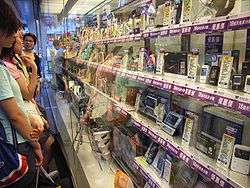
Starting from Dundas Street in Yau Ma Tei, it runs north and meets major roads, Argyle Street and Mong Kok Road, and ends at the junction with Prince Edward Road West. This street is a hot spot for Hong Kong people. The section south of Argyle Street concentrates shops of electronic products at street level and upstair bookstores above.
Part of Sai Yeung Choi Street South is pedestrianised on a part-time basis. The section of the street between Argyle Street and Dundas Street is closed to motorised traffic from 4:00 pm to 10:00 pm on Saturdays, and noon to 10:00 pm on Sundays and public holidays.[7]
The busiest portion of the street had, since 2000, been pedestrianised all week long. However, the Traffic and Transport Committee of the Yau Tsim Mong District Council voted on 21 November 2013 to restrict the pedestrianisation to weekends and public holidays only, citing complaints from local residents.[8] A survey conducted by the Home Affairs Department found that 80 per cent of residents and shop owners wanted to limit pedestrianisation, while most people questioned on the street wanted to keep the weekday pedestrianisation.[9] In spite of criticism, the pedestrianisation hours were reduced to weekends only with effect from January 2014.[7] Retail rents on the street subsequently dropped.[10]
Sai Yeung Choi Street North
Starting from Playing Field Road, it runs north, crossing Boundary Street into New Kowloon and terminates slight beyond Poplar Street. This street is largely residential and more quiet than the other street in the south. A much shorter, separated section of this street is to the north, between Sai Yeung Choi Lane and St. Francis' Church, separated by a hill slope.
Transportation
- Mong Kok Station (Exits B2, B3, D2, D3, E2)
- Prince Edward Station (Exits A, B2)
See also
| Wikimedia Commons has media related to Sai Yeung Choi Street. |
References
- ↑ Qizhang Dong, Atlas: The Archaeology of an Imaginary City (Columbia University Press, 2013), ISBN 978-0231504225, c. 38. Excerpts available at Google Books.
- ↑ "Buildings coming down". South China Morning Post. 9 August 1976. p. 7.
- ↑ "$100k reward posted for acid attack info". Hong Kong Government. 16 December 2008. Archived from the original on March 27, 2009.
- ↑ "Hong Kong acid attack leads to arrest". BBC News. 10 January 2010.
- ↑ Lo, Clifford; Lau, Jessie; Shirley, Zhao (10 June 2014). "Passer-by killed by chair 'thrown from 10-storey building'; psychiatric patient held". South China Morning Post.
- ↑ Kao, Ernest; Lau, Chris; Sung, Timmy; Mon, Danny (26 November 2014). "Stand-off ensues between protesters and police in Mong Kok". South China Morning Post.
- 1 2 "Change of implementation days for Mong Kok Pedestrianisation Schemes". Hong Kong Government. 17 January 2014.
- ↑ "Pedestrian Schemes for Mong Kok". Transport Department. Retrieved 5 June 2015.
- ↑ Chan, Candy (22 November 2013). "Mong Kok's pedestrian zone to operate only at weekends". South China Morning Post.
- ↑ Chiu, Karen (23 January 2014). "Mong Kok shop rents drop as vehicles return". The Standard.
| Kowloon City |
|
|---|---|
| Kwun Tong | |
| Sham Shui Po |
|
| Wong Tai Sin | |
| Yau Tsim Mong | |
| |
Coordinates: 22°19′19″N 114°10′10″E / 22.32195°N 114.16944°E