Saiki, Ōita
| Saiki 佐伯市 | |
|---|---|
| City | |
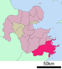 Location of Saiki in Ōita Prefecture | |
 Saiki Location in Japan | |
| Coordinates: 32°58′N 131°54′E / 32.967°N 131.900°ECoordinates: 32°58′N 131°54′E / 32.967°N 131.900°E | |
| Country | Japan |
| Region | Kyushu |
| Prefecture | Ōita Prefecture |
| Government | |
| • Mayor | Yasuyoshi Nishijima |
| Area | |
| • Total | 903.44 km2 (348.82 sq mi) |
| Population (May 2008) | |
| • Total | 78,069 |
| • Density | 86.4/km2 (224/sq mi) |
| Symbols | |
| • Tree | Oak |
| • Flower | Yamazakura (Prunus jamasakura) |
| • Bird | Japanese white-eye |
| • Fish |
Sea: Aji River: Ayu |
| Time zone | Japan Standard Time (UTC+9) |
| City hall address |
1-1, Nakamura Minamimachi, Saiki-shi, Ōita-ken 876-8585 |
| Website |
www |
Saiki (佐伯市 Saiki-shi) is a city located in Ōita Prefecture, Japan. The city was founded on April 29, 1941.
As of 2003, the former city had an estimated population of 49,183 and the population density of 249.19 persons per km2. The total area was 197.37 km2.
On March 3, 2005, Saiki absorbed the towns of Kamae, Kamiura, Tsurumi, Ume and Yayoi, and the villages Honjō, Naokawa and Yonōzu (all from Minamiamabe District) to create the new and expanded Saiki City.
As of 2008, the new city has an estimated population of 78,069 and a population density of 86.4 persons per km2. The total area is 903.44 km2, making it the largest city by area in Kyushu.
Sister city
In the sister city program, Saiki is twinned with the Australian port city Gladstone, Queensland, as well as a sister city with Handan, China.[1]
References
External links
 Media related to Saiki, Ōita at Wikimedia Commons
- Saiki City official website (Japanese)