Saint-Mathieu-d'Harricana, Quebec
| Saint-Mathieu-d'Harricana | |
|---|---|
| Municipality | |
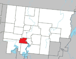 Location within Abitibi RCM. | |
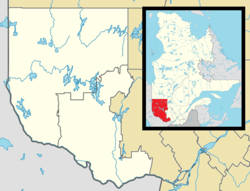 Saint-Mathieu-d'Harricana Location in western Quebec. | |
| Coordinates: 48°28′N 78°08′W / 48.467°N 78.133°WCoordinates: 48°28′N 78°08′W / 48.467°N 78.133°W[1] | |
| Country |
|
| Province |
|
| Region | Abitibi-Témiscamingue |
| RCM | Abitibi |
| Settled | 1912 |
| Constituted | January 1, 1943 |
| Government[2] | |
| • Mayor | Martin Roch |
| • Federal riding | Abitibi—Témiscamingue |
| • Prov. riding | Abitibi-Ouest |
| Area[2][3] | |
| • Total | 110.80 km2 (42.78 sq mi) |
| • Land | 106.80 km2 (41.24 sq mi) |
| Population (2011)[3] | |
| • Total | 696 |
| • Density | 6.5/km2 (17/sq mi) |
| • Pop 2006-2011 |
|
| • Dwellings | 309 |
| Time zone | EST (UTC−5) |
| • Summer (DST) | EDT (UTC−4) |
| Postal code(s) | J0Y 1M0 |
| Area code(s) | 819 |
| Highways |
|
Saint-Mathieu-d'Harricana is a municipality in the Canadian province of Quebec, located in the Abitibi Regional County Municipality. It is part of the census agglomeration of Amos.
Demographics
The municipality had a population of 696 as of the Canada 2011 Census.
As of the 2006 census, mother tongues spoken are:[4]
- English as first language: 0%
- French as first language: 100%
- English and French as first language: 0%
- Other as first language: 0%
Population trend:[5]
- Population in 2011: 696 (2006 to 2011 population change: -2.8%)
- Population in 2006: 716
- Population in 2001: 700
- Population in 1996: 717
- Population in 1991: 655
Municipal council
- Mayor: Martin Roch
- Councillors: Lucie Crépeault-Offroy, Gabriel Lemay, Félix Offroy, Érix Pomerleau, Simon Roy, Simon Simard
References
- ↑ Reference number 279847 of the Commission de toponymie du Québec (French)
- 1 2 "Saint-Mathieu-d'Harricana". Répertoire des municipalités (in French). Ministère des Affaires municipales, des Régions et de l'Occupation du territoire. Retrieved 2011-01-11.
- 1 2 "Saint-Mathieu-d'Harricana census profile". 2011 Census data. Statistics Canada. Retrieved 2011-01-11.
- ↑ "Saint-Mathieu-d'Harricana community profile". 2006 Census data. Statistics Canada. Retrieved 2011-01-11.
- ↑ Statistics Canada: 1996, 2001, 2006, 2011 census
 |
Sainte-Gertrude-Manneville | Amos | | |
| |
Saint-Marc-de-Figuery | |||
| ||||
| | ||||
| Preissac | La Motte |
| Towns | |
|---|---|
| Municipalities | |
| Townships | |
| Parishes | |
| Unorganized territories | |
| |
This article is issued from Wikipedia - version of the 11/5/2016. The text is available under the Creative Commons Attribution/Share Alike but additional terms may apply for the media files.