Saint Joseph, Vanderburgh County, Indiana
| Saint Joseph | |
|---|---|
| Unincorporated community | |
 | |
| Nickname(s): St. Joe County | |
 Saint Joseph  Saint Joseph | |
| Coordinates: 38°03′58″N 87°38′49″W / 38.06611°N 87.64694°WCoordinates: 38°03′58″N 87°38′49″W / 38.06611°N 87.64694°W | |
| Country | United States |
| State | Indiana |
| County | Vanderburgh |
| Township | German |
| Saint Joseph | 1867[1] |
| Founded by | German immigrants, 1841 |
| Named for | St. Joseph Catholic Church |
| Elevation[2] | 548 ft (167 m) |
| Time zone | CST (UTC-6) |
| • Summer (DST) | CDT (UTC-5) |
| ZIP code | 47720 |
| Area code(s) | 812 |
| GNIS feature ID | 442618 |
Saint Joseph, affectionately called St. Joe County by locals, is an unincorporated community in German Township, Vanderburgh County, Indiana, United States and centered on St. Joseph Catholic Church.[3] Along with that of Darmstadt, its colonization marked the beginning of German-American immigration to southern Indiana. The area was chosen as a settlement for its rich farmland.[4]
Name
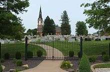
The town is named after the church in its center, St. Joseph Catholic Church. The church is named for the Saint Joseph the Carpenter, the father of Jesus. Unlike most other local communities, St. Joseph has never had a railway station.[5]
The nickname "St. Joe County" originates from the fact that there are multiple churches by the name of St. Joseph in the Roman Catholic Diocese of Evansville and Vincennes, and different names were needed to distinguish one from the next in conversation and on paperwork. The church is referred to as "St. Joe in the County", referring to the fact that the other St. Joseph Catholic Churches are located in Evansville ("St. Joe [in the] City") and Jasper "St. Joe [in] Jasper"). The name is frequently truncated to "St. Joe County", and members of the diocese have come to know the town as "St. Joe County".
Geography
Saint Joseph is located at 38°03′58″N 87°38′49″W / 38.06611°N 87.64694°W.
References
- ↑ Anna M. Ennis (1990). 1841 - 1991: Saint Joseph Catholic Church, Vanderburgh County: History of our journey. St. Meinrad: Abbey Press.
- ↑ "US Board on Geographic Names". United States Geological Survey. October 25, 2007. Retrieved 2016-07-18.
- ↑ "Saint Joseph, Indiana". Geographic Names Information System. United States Geological Survey. Retrieved 2016-07-18.
- ↑ "Historic Property Report Section 1, I-64/I-164/SR 57 to SR 64: I-69 Evansville to Indianapolis, Tier 2" (PDF). Federal Highway Administration and Indiana Department of Transportation. November 21, 2005. p. 17. Retrieved June 5, 2009.
- ↑ Indiana Department of Geology and Natural Resources (1910). "Annual report". 34: 167.
Municipalities and communities of Vanderburgh County, Indiana, United States | ||
|---|---|---|
| City | ||
| Town | ||
| Townships | ||
| CDPs | ||
| Unincorporated communities | ||
| Footnotes | ‡This populated place also has portions in an adjacent county or counties | |