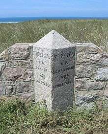
Saint Peter, Jersey
| Saint Peter | ||
|---|---|---|
| Jersey parish | ||
|
Welcome to Jersey sign at Jersey Airport | ||
| ||
 Location of Saint Peter in Jersey | ||
| Crown Dependency | Jersey, Channel Islands | |
| Government[1] | ||
| • Connétable | John Refault | |
| Area | ||
| • Total | 11.6 km2 (4.5 sq mi) | |
| Area rank | Ranked 4th | |
| Elevation[2] | 84 m (276 ft) | |
| Population (2011) | ||
| • Total | 5,003 | |
| • Density | 430/km2 (1,100/sq mi) | |
| Time zone | GMT | |
| • Summer (DST) | UTC+01 (UTC) | |
| Postcode district | JE3 | |
| Postcode sector | 7 | |
Saint Peter (Jèrriais: St Pièrre) is one of the twelve parishes of Jersey in the Channel Islands. It is in the west central part of the island. It is the only parish with two separate coastlines, stretching from St. Ouen's Bay in the west to St. Aubin's Bay in the south, and thereby cutting St. Brelade off from other parishes. The parish is the fourth-largest parish by surface area, covering 6,469 vergées (11.6 km2 (4.5 sq mi))
It borders four other parishes:
- Saint Ouen to the north
- Saint Mary to the north-east
- St Lawrence to the east
- St Brelade to the south
A large portion of the parish is occupied by Jersey Airport.
The traditional nickname for St. Pierrais is ventres à baînis (limpet bellies), perhaps because their parish sticks to two coasts like limpets.
Vingtaines
| Historical population | ||
|---|---|---|
| Year | Pop. | ±% |
| 1991 | 4,231 | — |
| 1996 | 4,228 | −0.1% |
| 2001 | 4,293 | +1.5% |
| 2011 | 5,003 | +16.5% |
The parish is divided into vingtaines for administrative purposes as follows:
- La Vingtaine du Douet
- La Vingtaine de St. Nicolas
- La Grande Vingtaine
- La Vingtaine des Augerez
- La Vingtaine du Coin Varin
The parish forms one electoral district and elects one Deputy.
Education

St. Peter's School is located in La Rue du Presbytère, and is a state run primary school with 164 students in 2009.[3] The fee-charging St. George's Preparatory School is located at La Hague Manor, Rue de la Hague, which is wholly owned by The Jersey Educational Trust.[4]
Notable residents
- Gilbert O'Sullivan resides in Saint Peter with his wife Aase and their two children.
- Caroline LeSueur, a Mormon pioneer and one of the founders of St. Johns, Arizona.
- Augustus Asplet Le Gros, a Norman language poet and a Jurat of the Royal Court of Jersey.
- George William de Carteret, a Norman language journalist and writer
- Peter Vincenti, footballer
References
- ↑ "Election results 2011". Gov.je. Retrieved 2012-10-05.
- ↑
- ↑ St. Peter's School
- ↑ St. George's Preparatory
External links
- Saint Peter, Official Parish website
- St Pièrre at Les Pages Jèrriaises
- St. Peter's School
- St. George's Preparatory School
Coordinates: 49°13′05″N 2°11′28″W / 49.21805°N 2.19109°W

.svg.png)