Sainte-Cécile, Belgium
| Sainte-Cécile | |
|---|---|
| Municipality | |
|
View of the village | |
 Sainte-Cécile Location in Belgium | |
|
Location of Sainte-Cécile in Belgium  | |
| Coordinates: 49°43.7′N 05°14.5′E / 49.7283°N 5.2417°ECoordinates: 49°43.7′N 05°14.5′E / 49.7283°N 5.2417°E | |
| Country | Belgium |
| Community | French Community |
| Region | Wallonia |
| Province | Luxembourg |
| Arrondissement | Arrondissement of Virton |
| Area | |
| • Total | 146.91 km2 (56.72 sq mi) |
| Population (1 January 2016)[1] | |
| • Total | 5,632 |
| • Density | 38/km2 (99/sq mi) |
| Postal codes | 6820 |
| Area codes | 061 |
| Website | Sainte-Cécile |
.JPG)
Sainte-Cécile is a village in the municipality of Florenville in Belgium. It lies in the country's Walloon Region and in the province of Luxembourg.
Geography
The village is bordered in the east by the Semois, a tributary to the Meuse river.
References
- ↑ Population per municipality as of 1 January 2016 (XLS; 397 KB)
External links
- Official web site (French)
| Wikimedia Commons has media related to Sainte-Cécile. |
Municipalities of Luxembourg Province | ||
|---|---|---|
| Arlon | 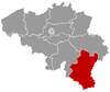 | |
| Bastogne | ||
| Marche-en-Famenne | ||
| Neufchâteau | ||
| Virton | ||
This article is issued from Wikipedia - version of the 3/7/2016. The text is available under the Creative Commons Attribution/Share Alike but additional terms may apply for the media files.