Samut Prakan Province
| Samut Prakan สมุทรปราการ | ||
|---|---|---|
| Province | ||
 | ||
| ||
 Map of Thailand highlighting Samut Prakan Province | ||
| Country | Thailand | |
| Capital | Samut Prakan | |
| Government | ||
| • Governor | Chatchai Uthaiphan (since October 2016) | |
| Area | ||
| • Total | 1,004.1 km2 (387.7 sq mi) | |
| Area rank | Ranked 70th | |
| Population (2014) | ||
| • Total | 1,261,530[1] | |
| • Rank | Ranked 18th | |
| • Density rank | Ranked 3rd | |
| Time zone | ICT (UTC+7) | |
| ISO 3166 code | TH-11 | |
| Website |
www | |

Samut Prakan (Thai: สมุทรปราการ, pronounced [sāmùt prāːkāːn]) is one of the central provinces (changwat) of Thailand, established by the Act Establishing Changwat Samut Prakan, Changwat Nonthaburi, Changwat Samut Sakhon and Changwat Nakhon Nayok, Buddhist Era 2489 (1946), which came into force 9 March 1946.
It is part of the Bangkok Metropolitan Region. Neighbouring provinces are Bangkok, to the north and west, and Chachoengsao to the east.
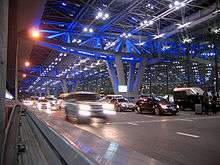
Suvarnabhumi Airport is in the Bang Phli District of Samut Prakan Province.
History
The province was created during the Ayutthaya period, with its administrative centre at Prapadaeng. It was the sea port of Siam, and was secured with forts, town moats, and town walls. King Rama II started the building of the new centre at Samut Prakan in 1819, after his predecessor King Taksin had abandoned the town fortifications. Altogether six forts were built on both sides of the Chao Phraya River, and on an island in the river the pagoda, Phra Samut Chedi, was erected. These were involved in the Paknam incident of 13 July 1893, which ended the Franco-Siamese War with a French naval blockade of Bangkok. Of the original six forts only two still exist today, Phi Sua Samut and Phra Chulachomklao.
Etymology
In Thai the word samut is from Sanskrit, samudra, meaning "ocean" or "sea", and the word prakan is from Sanskrit, prākāra, meaning "fortress", "walls", or "stronghold".
Geography
- Pak Nam and Paknam redirect here
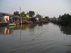
Samut Prakan is at the mouth of the Chao Phraya River on the Gulf of Thailand. Thus the province is also sometimes called Pak Nam (ปากน้ำ), the Thai word for the mouth of a river. The part of the province on the west side of the river consists mostly of rice paddies and shrimp farms as well as mangrove forests, while the eastern part is the urban centre, including industrial factories. It is part of the Bangkok metropolis. The urbanization on both sides of the provincial boundary is identical. The province has a coastline of approximately 47.2 kilometres.
Places
- Bang Pu Nature Reserve, about 12 km east of the town centre, has a large bird population. Especially during the winter, the Sakdi pier at Bang Pu is very popular for Thai people feeding the wintering seagulls. The park is run jointly by the Royal Thai Army and the Thai WWF, and was officially established on the 72nd birthday of Queen Sirikit in 2004.
- The HTMS Maeklong, a former Royal Thai Navy ship is moored in concrete at Chulachomklao Fort at the mouth of the Chao Phraya in Amphoe Phra Samut Chedi.
- Two major tourist attractions of the province are in Amphoe Mueang Samut Prakan, the capital district: Mueang Boran or "ancient city", a park that features down scaled replicas of all major historical buildings of Thailand; and the Crocodile Farm.
- Besides being the home of Suvarnabhumi Airport, Amphoe Bang Phli is famous for the annual Lotus Flower (Rap Bua) Festival, which usually takes place on the full moon in October.
Symbols
The provincial seal shows the temple Phra Samut Chedi, the most important site of Buddhist worship in the province.
The provincial tree is Thespesia populnea.
The provincial slogan is Marine Battle Fortresses, Chedi in the Water, Crocodile Farm, Exquisite Ancient City, Phra Pradaeng Songkran Festival, Tasty Dried Snakeskin Gourami, Rap Bua Festival, Industrial Estate
Administrative divisions
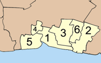
The province is divided into six districts (amphoe). The districts are further subdivided into 50 sub-districts (tambon) and 396 villages (muban). There is one city (thesaban nakhon), three towns (thesaban mueang) and 13 sub-district municipalities (thesaban tambon). For national elections the province is divided into three voting districts, one represented by three assemblyman and the other two each by two assemblymen.
References
- ↑ "Population of the Kingdom" (PDF). Department of Provincial Affairs (DOPA) Thailand (in Thai). 2014-12-31. Retrieved 19 Mar 2015.
External links
 Samut Prakan travel guide from Wikivoyage
- Province page from the Tourist Authority of Thailand
- paknam.com - created by Sriwittayapaknam School
- Official site of the province (Thai only)
- Samut Prakan provincial map, coat of arms and postal stamp
 |
Bangkok | Chachoengsao Province | | |
| |
||||
| ||||
| | ||||
| Bight of Bangkok |
Coordinates: 13°35′58″N 100°35′48″E / 13.59944°N 100.59667°E