San Pedro de Quemes Municipality
| San Pedro de Quemes | |
|---|---|
| Municipality | |
|
Salar de Chiguana | |
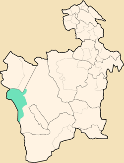 Location within Potosí Department | |
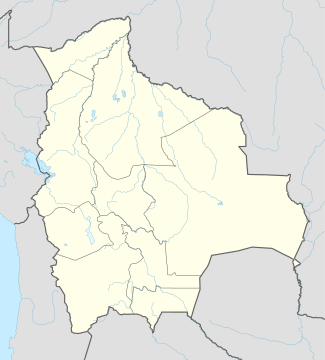 San Pedro de Quemes Location within Bolivia | |
| Coordinates: 21°3′S 68°18′W / 21.050°S 68.300°WCoordinates: 21°3′S 68°18′W / 21.050°S 68.300°W | |
| Country |
|
| Department | Potosí Department |
| Province | Nor Lípez Province |
| Seat | San Pedro de Quemes |
| Area | |
| • Total | 1,657 sq mi (4,291 km2) |
| Elevation | 13,000 ft (4,000 m) |
| Population (2001) | |
| • Total | 815 |
| • Ethnicities | Quechua |
| Time zone | -4 (UTC-4) |

San Pedro de Quemes Municipality is the second municipal section of the Nor Lípez Province in the Potosí Department in Bolivia. Its seat is San Pedro de Quemes.
Geography
The municipality lies at the Uyuni salt flat.
Some of the highest mountains of the municipality are listed below:[1][2][3][4][5]
- Araral
- Chiwana
- Ch'aska Urqu
- Iru Phutunqu
- Julina
- Kachi Unu
- K'uchu Unu
- Luxsar
- Michincha
- Millu Urqu
- Paruma
- Patilla
- Phuruncha
- Q'aluta Wintu Luma
- Sarapuru
- Tankani
- Tirani
- Ukilla
- Ullawi
- Ullqa
- Wanaku
- Yarita
Many of the mountains and volcanoes are a natural border to Chile.
Subdivision
The municipality consists of the following cantons:[6]
- Cana - 44 inhabitants (2001)
- Chiguana - 10 inhabitants
- Pajancha - 52 inhabitants
- Pelcoya - 135 inhabitants
- San Pedro de Quemes- 574 inhabitants
The people
The people are mainly not indigenous and 45,0% are citizens of Quechua descent.[7]
| Ethnic group | % |
|---|---|
| Quechua | 45.0 |
| Aymara | 6.3 |
| Guaraní, Chiquitos, Moxos | 0.2 |
| Not indigenous | 48.3 |
| Other indigenous groups | 0.2 |
See also
References
- ↑ "San Pedro de Quemes". Retrieved October 16, 2015.
- ↑ Bolivian IGM map 1:50,000 Chiguana 6030-IV
- ↑ Bolivian IGM map 1:50,000 Estancia Chilala 6031-IV
- ↑ Bolivian IGM map 1:50,000 Villa Martín 6031-I
- ↑ "South America Maps". Joint Operations Graphic. Retrieved October 16, 2015.
- ↑ National Institute of Statistics of Bolivia
- ↑ obd.descentralizacion.gov.bo/municipal/fichas/ (inactive)
External links
Capital: Potosí | ||
| Provinces |  | |
| Municipalities (and seats) |
| |
This article is issued from Wikipedia - version of the 6/10/2016. The text is available under the Creative Commons Attribution/Share Alike but additional terms may apply for the media files.