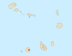
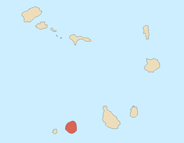
Santa Catarina do Fogo, Cape Verde
| Santa Catarina do Fogo | |
|---|---|
| Municipality | |
 | |
| Coordinates: 14°54′N 24°20′W / 14.90°N 24.33°WCoordinates: 14°54′N 24°20′W / 14.90°N 24.33°W | |
| Country | Cape Verde |
| Island | Fogo |
| Area | |
| • Total | 152.95 km2 (59.05 sq mi) |
| Population (2010)[1] | |
| • Total | 5,299 |
| • Density | 35/km2 (90/sq mi) |
Santa Catarina do Fogo is a concelho (municipality) of Cape Verde. Situated in the southeastern part of the island of Fogo, it covers 32% of the island area, and is home to 14% of its population. Its seat is the town Cova Figueira.
Subdivisions
The municipality consists of one freguesia (civil parish), Santa Catarina do Fogo. The freguesia is subdivided into the following settlements, its population was of the 2010 census:
- Achada Furna (pop: 495)
- Achada Poio (pop: 61)
- Baluarte
- Cabeça Fundão (pop: 177)
- Chã das Caldeiras (pop: 697)
- Cova Figueira (pop: 1,230)
- Domingo Lobo (pop: 254)
- Estância Roque (pop: 411)
- Figueira Pavão (pop: 320)
- Fonte Aleixo (pop: 401)
- Mãe Joana (pop: 130)
- Monte Vermelho (pop: 221)
- Roçadas (pop: 372)
- Tinteira (pop: 410)
History
It was created in 1808, when a parish of the older Municipality of São Filipe was separated to become the Municipality of Santa Catarina do Fogo. Between the late 19th century and 2005, it remained a part of São Filipe Municipality.
Demography
| Population of Santa Catarina do Fogo, Cape Verde (1940—Present) | |||||||
|---|---|---|---|---|---|---|---|
| 1940 | 1950 | 1960 | 1970 | 1980 | 1990 | 2000[2] | 2010[1] |
| 650 | 1,000 | 1,123 | 4,650 | 8,200 | 10,000 | 12,898 | 5,299 |
Politics
Since 2012, the PAICV is the ruling party of the municipality which won 52% in the last election.
Municipal assembly
| 2004 % | 2004 seats | 2008 % | 2008 seats | 2012 % | 2012 seats | |
|---|---|---|---|---|---|---|
| PAICV | 50.46 | 11 | 28.8 | - | 52 | 7 |
| Movement for Democracy | 44.2 | 10 | 66 | - | 46.4 | 6 |
| PCD-PRD | 4.07 | 0 | - | - | - | - |
| NU BAI | 1.27 | 0 | - | - | - | - |
Municipality
| 2004 % | 2004 seats | 2008 % | 2008 seats | 2012 % | 2012 seats | |
|---|---|---|---|---|---|---|
| PAICV | 50.42 | 9 | 67.8 | 5 | 52.3 | 5 |
| Movement for Democracy | 43.95 | 0 | - | - | 46.4 | 0 |
| PCD-PRD | 4.22 | 0 | - | - | - | - |
| NU BAI | 1.4 | 0 | - | - | - | - |
Sports
Its sporting clubs includes Desportivo de Cova Figueira, Baxada and Parque Real.
Twin towns
Santa Catarina do Fogo are twinned with two Portuguese municipalities:
External links
References
- 1 2 "2010 Census results". Instituto Nacional de Estatística Cabo Verde (in Portuguese). 17 March 2014.
- ↑ Source: projections from the Instituto Nacional de Estatísticas.
The Island of Fogo | ||
|---|---|---|
| Towns, villages and settlements |
|  |
| Mountains | ||
| Municipalities | ||
| Parishes | ||