Scandinavian Mountains
| Scandinavian Mountains | |
|---|---|
| Skanderna, Fjällen, Kjølen, Köli, Skandit | |
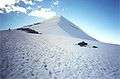
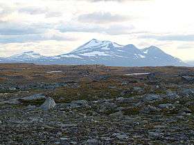 Mount Áhkká in Stora Sjöfallet National Park, Northern Sweden | |
| Highest point | |
| Peak | Galdhøpiggen (Lom) |
| Elevation | 2,469 m (8,100 ft) [1] |
| Coordinates | 61°38′11″N 08°18′45″E / 61.63639°N 8.31250°E |
| Dimensions | |
| Length | 1,700 km (1,100 mi) [2] |
| Width | 320 km (200 mi) [2] |
| Geography | |
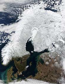
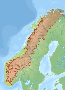
 The Scandinavian Mountains | |
| Countries | Norway, Sweden and Finland |
| Range coordinates | 65°N 14°E / 65°N 14°ECoordinates: 65°N 14°E / 65°N 14°E |
The Scandinavian Mountains or the Scandes is a mountain range that runs through the Scandinavian Peninsula. The Scandinavian Mountains are often erroneously thought to be equivalent to the Scandinavian Caledonides. The western sides of the mountains drop precipitously into the North Sea and Norwegian Sea, forming the famous fjords of Norway, whereas to the northeast they gradually curve towards Finland. To the north they form the border between Norway and Sweden, still reaching 2,000 m high (6,600 ft) at the Arctic Circle. The mountain range just touches northwesternmost Finland, but are scarcely more than hills at their northernmost extension at the North Cape (Nordkapp).
The mountains are not very high, but are very steep at places; Galdhøpiggen in southern Norway is the highest peak, at 2,469 metres (8,100 ft), Kebnekaise has the highest peak on the Swedish side, at 2,104 m (6,903 ft), whereas Halti is the highest peak in Finland, at 1,324 m (4,344 ft).
The combination of a northerly location and moisture from the North Atlantic Ocean has caused the formation of many ice fields and glaciers. Temperature drops with increasing altitude, and permafrost becomes common from about 1,500 meters above sea level on their western slope in Southern Norway and at about 1,200 meter AMSL on their eastern slope in Southern Norway near the border with Sweden. In Northern Norway, permafrost becomes common from about 800 to 900 meters AMSL on the western slope and some 200- to 300-meters-lower on the eastern slope.[3]

The Scandinavian Montane Birch forest and grasslands terrestrial ecoregion is closely associated with the mountain range.
Names in Scandinavia
Its names in the Scandinavian languages are, in Swedish Skanderna,[4] Fjällen ("the Fells") or Kölen (Fjällen being by far the most frequent name and virtually the only one in modern colloquial speech in Sweden) and in Norwegian Kjølen, with the three latter meaning The Keel.
Orography
The mountain chain's highest summits are mostly concentrated in an area (of mean altitude of over 1000 m[5]) between Stavanger and Trondheim in southern Norway, with numerous peaks over 1300 m and some peaks over 2000 m. Around Trondheim Fjord peaks decrease in altitude to about 400–500 m rising again to heights in excess of 1900 m further north in Swedish Lapland and nearby areas of Norway.[6][upper-alpha 1] The southern part of the mountain range contains the highest mountain of Northern Europe, Galdhøpiggen at almost 2500 m.[8] This part of the mountain chain is also broader and contains a series of plateaux and gently undulating surfaces[6][9] that hosts scattered inselbergs.[9] In south-western Norway the plateaux and gently undulating surfaces are strongly dissected by fjords and valleys.[10] The mountain chain is present in Sweden from northern Dalarna northwards; south of this point the Scandinavian Mountains lie completely within Norway.[6] Most of the Scandinavian Mountains lack "alpine topography", and where it does have it it does relate to altitude.[9]
To the east the Scandinavian Mountains proper bounds with mountains that are lower and less dissected and are known as the förfjäll (literally "fore-fell"). While lower than the Scandinavian Mountains proper, the förfjäll's more pronounced relief, its often larger number of plateaux and its coherent valley systems distinguish it from so-called undulating hilly terrain (bergkullsterräng) and plains with residual hills (bergkullslätt) found further east. Generally the förfjäll do not surpass 1000 m.a.s.l. As a geomorphic unit the förfjäll extends across Sweden as a 650 km long and 40 to 80 km broad belt from Dalarna in the south to Norrbotten in the north.[11]
Geology
Origin of the mountains
The origin of today's mountain topography is debated by geologists.[12] During the Paleozoic, a continental collision between Scandinavia (then part of Baltica) and Greenland (then part of Laurentia) produced a Himalayas-sized mountain range named the Caledonian Mountains roughly over the same area as the present-day Scandinavian Mountains.[13][14] In Scandinavia the Caledonian Mountains begun a post-orogenic collapse in the Devonian implying tectonic extension and subsidence.[15] Despite occurring in about the same area the ancient Caledonian Mountains and the modern Scandinavian Mountains are unrelated.[upper-alpha 2]
Geologically, the Scandivian Mountains are an elevated, passive continental margin similar to the mountains and plateaux found on the opposite side of the North Atlantic in Eastern Greenland or in Australia's Great Dividing Range.[14] The Scandinavian Mountains attained its height by tectonic processes different from orogeny, chiefly in the Cenozoic.[17] A two-stage model of uplift has been proposed for the Scandinavian Mountains in southern Norway. A first stage in the Mesozoic and a second stage starting from the Oligocene.[13] The uplift of southern Norway has elevated the westernmost parts of the sub-Cambrian peneplain forming all or parts of what is known as the Paleic surface[upper-alpha 3] in Norway.[19][20] In southern Norway the Scandinavian Mountains had their main uplift phase later (Neogene) than in northern Scandinavia which had its main phase of uplift in the Paleogene. The uplift in the north tilted the landsurface to the east, as reflected in the Muddus plains landscape.[21]
Unlike orogenic mountains there is no geophysical model that explains elevated passive continental margins such as the Scandinavian Mountains.[22] Various mechanisms of uplift have, however, been proposed over the years. Some have stressed the role of climate in inducing erosion that induces an isostatic compensation;[16] fluvial and glacial erosion and incision during the Quaternary is thought to have contributed to the uplift of the mountain by forcing an isostatic response.[16][12] The total amount of uplift produced by this mechanism could be as much as 500 m.[12] Others geoscientists have implied diapirism in the asthenosphere as being the cause of uplift.[16] One hypothesis claim that the early uplift of the Scandinavian Mountains could be indebted to changes in the density of the lithosphere and asthenosphere caused by the Iceland plume when Greenland and Scandinavia rifted apart about 53 million years ago.[23]
Quaternary geology
Many slopes and valleys have straight courses due to the fact that they follow tectonic fractures that are more prone to erosion.[10] Another result of tectonics in the relief is that slopes corresponding to footwalls of normal faults tend to be straight.[9]
There is evidence that the drainage divide between the Norwegian Sea and the south-east flowing rivers were once further west.[10] Glacial erosion is thought to have contributed to the shift of the divide, which in some cases ought to have in excess of 50 km.[10] Much of the Scandinavian Mountains has been sculpted by glacal erosion. The mountain chain is dotted with glacial cirques usually separated from each other by pre-glacial surfaces. At some locations coalesced cirques form arêtes and pyramidal peaks. Glacial reshaping of valleys is more marked in the western part of the mountain chain where drowned glacier-shaped valleys constitute the fjords of Norway. In the eastern part of the mountain chain glacial reshaping of valleys is weaker.[6] Many mountain tops contain blockfields which escaped glacial erosion either by having constituted nunataks in the glacial periods or by being protected from erosion under cold-based glacier ice.[10] Karst systems, with their characteristic caves and sinkholes occur at various locations in the Scandinavian Mountains but are more common in the northern parts. Present-day karst systems might have long histories dating back to the Pleistocene or even earlier times.[10]
Much of the mountain range is mantled by deposits of glacial origin including till blankets, moraines, drumlins and glacifluvial material in the form of outwash plains and eskers. Bare rock surfaces are more common in the western side of the mountain range. Although the ages of these deposits and landforms vary, most of them were formed in connection to the Weichselian glaciation and the subsequent deglaciation.[10]
Highest mountains
Norway
Of the 10 highest mountain peaks in Scandinavia (prominence greater than 30 m or 98 ft), six are situated in Oppland, Norway. The other four are situated in Sogn og Fjordane, Norway. There are 83 peaks equal to or taller than 2,200 m (7,218 ft) in Norway.
- 2,469 m (8,100 ft) Galdhøpiggen (Oppland)
- 2,465 m (8,087 ft) Glittertind (Oppland)
- 2,405 m (7,890 ft) Store Skagastølstind (Sogn og Fjordane)
- 2,387 m (7,831 ft) Store Styggedalstinden east (Sogn og Fjordane)
- 2,373 m (7,785 ft) Skarstind (Oppland)
- 2,369 m (7,772 ft) Vesle Galdhøpiggen (Oppland)
- 2,368 m (7,769 ft) Surtningssue (Oppland)
- 2,366 m (7,762 ft) Store Memurutinden (Oppland)
- 2,351 m (7,713 ft) Jervvasstind (Sogn og Fjordane)
- 2,348 m (7,703 ft) Sentraltind (Sogn og Fjordane)
 |
| This article is part of a series on |
| Scandinavia |
|---|
| Geography |
| Viking Age |
| Political entities |
| Former political entities |
| History |
| Other topics |
-
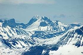
Galdhøpiggen seen from west, Norway's highest mountain
-
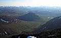
Landscape between Abisko National Park and Kebnekaise

Sweden
There are 12 peaks in Sweden that reach above 2,000 m high (6,600 ft), or 13 depending on how the peaks are defined. This list is defined according to UIAA. Eight of them are located in Sarek National Park and the neighbouring national park Stora Sjöfallet. The other four peaks are located in the further north region of Kebnekaise. All mountain names are in Sami but with the more common Swedish spelling of it.
- 2,104 m (6,903 ft) Kebnekaise (Lappland) - Note: Altitude includes the peak glacier. If melting continues, Kebnekaise Nordtoppen, just 500 meters away, might become the highest point.
- 2,097 m (6,880 ft) Kebnekaise Nordtoppen (Lappland) - the highest fixed point in Sweden.
- 2,089 m (6,854 ft) Sarektjåkkå Stortoppen (Lappland)
- 2,076 m (6,811 ft) Kaskasatjåkka (Lappland)
- 2,056 m (6,745 ft) Sarektjåkkå Nordtoppen (Lappland)
- 2,043 m (6,703 ft) Kaskasapakte (Lappland)
- 2,023 m (6,637 ft) Sarektjåkkå Sydtoppen (Lappland)
- 2,016 m (6,614 ft) Akka Stortoppen (Lappland)
- 2,010 m (6,594 ft) Akka Nordvästtoppen (Lappland)
- 2,010 m (6,594 ft) Sarektjåkkå Buchttoppen (Lappland)
- 2,005 m (6,578 ft) Pårtetjåkka (Lappland)
- 2,002 m (6,568 ft) Palkatjåkka (Lappland)
Other popular mountains for skiers, climbers and hikers in Sweden
- Sulitelma 1,860 m (Lappland)
- Helagsfjället 1,796 m (Härjedalen)
- Norra Storfjället 1,767 m (Lappland)
- Templet 1,728 m (Jämtland)
- Lillsylen 1,704 m (Jämtland)
- Åreskutan 1,420 m (Jämtland)
- Storvätteshågna 1,204 m (Dalarna)
- Molnet 1,191 m (Dalarna)
Finland

- 1,324 m (4,344 ft) Halti (Lappi/Lappland and Norwegian Troms)
- 1,317 m (4,321 ft) Ridnitsohkka (Lappi/Lappland)
- 1,280 m (4,200 ft) Kiedditsohkka (Lappi/Lappland)
- 1,240 m (4,068 ft) Kovddoskaisi (Lappi/Lappland)
- 1,239 m (4,065 ft) Ruvdnaoaivi (Lappi/Lappland)
- 1,180 m (3,871 ft) Loassonibba (Lappi/Lappland)
- 1,150 m (3,773 ft) Urtasvaara (Lappi/Lappland)
- 1,144 m (3,753 ft) Kahperusvaarat (Lappi/Lappland)
- 1,130 m (3,707 ft) Aldorassa (Lappi/Lappland)
- 1,100 m (3,608 ft) Kieddoaivi (Lappi/Lappland)
As of July 2016, to mark the centenary of Finland's independence in 2017, the government of Norway is considering adjusting Norway's border with Finland in the Halti area, giving Finland a 1,331 m peak (one of the two peaks of Halti), which would become Finland's highest point.[24]
The highest independent prominence in Finland is Taivaskero (807 m high) in Pallas-Yllästunturi National Park.
See also
Notes
- ↑ The two high areas, north and south of Trondheim, have been usually referred to as "domes" but technically they are not geological domes.[7]
- ↑ The overlap between the Scandinavian Caledonides and the Scandinavian Mountains has led to various suggestions that the modern Scandinavian Mountains are a remnant of the Caledonide mountains.[14][16] A version of this argument was put forward in 2009 with the claim that the uplift of the mountains was attained by buoyancy of the surviving "mountain roots" of the Caledonian orogen.[14] This concept has been criticized since, at present, there is only a tiny "mountain root" beneath the southern Scandinavian Mountains and no "root" at all in the north. Further, the Caledonian Mountains in Scandinavia are known to have undergone orogenic collapse for a long period starting in the Devonian.[14][17][15] Another problem with this model is that it does not explain why other former mountains dating back to the Caledonian orogeny are eroded and buried in sediments and not uplifted by their "roots".[14]
- ↑ After being first described hy Hans Reusch in 1901 the Paleic surface was subject of various interpretations in the 20th century.[14][18]
References
- ↑ "Galdhøpiggen". Nationalencyklopedin (in Swedish). Retrieved 18 July 2010.
- 1 2 Lindström, Maurits. "fjällkedjan". Nationalencyklopedin (in Swedish). Retrieved 18 July 2010.
- ↑ http://www.cicero.uio.no/fulltext/index.aspx?id=9539
- ↑ "- Nordryggen, hæ ?" [The North Ridge, what]. Dagbladet (in Norwegian). 14 September 2013.
- ↑ "The delineation of European mountain areas" (PDF). Mountain Areas in Europe – Final Report. European Commission. p. 27. Retrieved 4 November 2016.
- 1 2 3 4 Rudberg, Sten (1960). "Geology and Morphology". In Somme, Axel. Geography of Norden. p. 27–40.
- ↑ Redfield, T.F.; Osmundsen, P.T. (2013). "The long-term topographic response of a continent adjacent to a hyperextended margin: A case study from Scandinavia". GSA Bulletin. 125 (1/2): 184–200. doi:10.1130/B30691.1.
- ↑ Skandinaviske fjellkjede
- 1 2 3 4 Osmundsen, P.T.; Redfield, T.F.; Hendriks, B.H.W.; Bergh, S.; Hansen, J.-A.; Henderson, I.H.C.; Dehls, J.; Lauknes, T.R.; Larsen, Y.; Anda, E.; Davidsen, B. (2010). "Fault-controlled alpine topography in Norway". Journal of the Geological Society, London. 167: 83–98. doi:10.1144/0016-76492009-019.
- 1 2 3 4 5 6 7 Corner, Geoffrey (2004). "Scandes Mountains". In Seppälä, Matti. The Physical Geography of Fennoscandia. Oxford University Press. p. 240–254. ISBN 0-19-924590-8.
- ↑ Terrängformer i Norden (in Swedish). Nordiska ministerrådet. 1984. p. 10.
- 1 2 3 Medvedev, Sergei; Hartz, Ebbe H. (2015). "Evolution of topography of post-Devonian Scandinavia: Effects and rates of erosion". Geomorphology. 231: 229–245.
- 1 2 Gabrielsen, Roy H.; Faleide, Jan Inge; Pascal, Christophe; Braathen, Alvar; Nystuen, Johan Petter; Etzelmuller, Bernd; O'Donnel, Sejal (2010). "Latest Caledonian to Present tectonomorphological development of southern Norway". Marine and Petroleum Geology. 27: 709–723.
- 1 2 3 4 5 6 7 Green, Paul F.; Lidmar-Bergström, Karna; Japsen, Peter; Bonow, Johan M.; Chalmers, James A. (2013). "Stratigraphic landscape analysis, thermochronology and the episodic development of elevated, passive continental margins". Geological Survey of Denmark and Greenland Bulletin. 30: 18. Retrieved 30 April 2015.
- 1 2 Dewey, J.F.; Ryan, P.D.; Andersen, T.B. (1993). "Orogenic uplift and collapse, crustal thickness, fabrics and metamorphic phase changes: the role of eclogites". Geological Society, London, Special Publications. 76 (1): 325–343.
- 1 2 3 4 Schiffer, Christian; Balling, Neils; Ebbing, Jörg; Holm Jacobsen, Bo; Nielsen, Søren Bom (2016). "Geophysical-petrological modelling of the East Greenland Caledonides – Isostatic support from crust and upper mantle". Tectonophysics.
- 1 2 Chalmers, J.A.; Green, P.; Japsen, P.; Rasmussen, E.S. (2010). "The Scandinavian mountains have not persisted since the Caledonian orogeny. A comment on Nielsen et al. (2009a)". Journal of Geodynamics. 50: 94–101.
- ↑ Gjessing, Just (1967). "Norway's Paleic Surface". Norsk Geografisk Tidsskrift. 21 (2): 69–132. doi:10.1080/00291956708621854.
- ↑ Lidmar-Bergström, Karna. "Paleiska ytan". Nationalencyklopedin (in Swedish). Cydonia Development. Retrieved June 22, 2015.
- ↑ Jarsve, Erlend M.; Krøgli, Svein Olav; Etzelmüller, Bernd; Gabrielsen, Roy H. (2014). "Automatic identification of topographic surfaces related to the sub-Cambrian peneplain (SCP) in Southern Norway—Surface generation algorithms and implications". Geomorphology. Elsevier. 211: 89–99.
- ↑ Lidmar-Bergström, K.; Näslund, J.O. (2002). "Landforms and uplift in Scandinavia". In Doré, A.G.; Cartwright, J.A.; Stoker, M.S.; Turner, J.P.; White, N. Exhumation of the North Atlantic Margin: Timing, Mechanisms and Implications for Petroleum Exploration. Geological Society, London, Special Publications. The Geological Societ y of London. p. 103–116.
- ↑ Bonow, Johan M. (2009). "atlantens kustberg och högslätter – gamla eller unga?" (PDF). www.geografitorget.se (in Swedish). Geografilärarnas Riksförening.
- ↑ Nielsen, S.B.; Paulsen, G.E.; Hansen, D.L.; Gemmer, L.; Clausen, O.R.; Jacobsen, B.H.; Balling, N.; Huuse, M.; Gallagher, K. (2002). "Paleocene initiation of Cenozoic uplift in Norway". In Doré, A.G.; Cartwright, J.A.; Stoker, M.S.; Turner, J.P.; White, N. Exhumation of the North Atlantic Margin: Timing, Mechanisms and Implications for Petroleum Exploration. Geological Society, London, Special Publications. The Geological Societ y of London. p. 103–116.
- ↑ Henley, Jon (28 July 2016). "Norway considers giving mountain to Finland as 100th birthday present". The Guardian. Retrieved 4 November 2016.
External links
![]() Media related to Scandinavian Mountains at Wikimedia Commons
Media related to Scandinavian Mountains at Wikimedia Commons