Scratchgravel Hills
| Scratchgravel Hills | |
|---|---|
|
Scratchgravel Hills as viewed from Lake Helena | |
| Highest point | |
| Elevation | 5,233 feet (1,595 m) |
| Coordinates | 46°40′35″N 112°05′04″W / 46.67639°N 112.08444°WCoordinates: 46°40′35″N 112°05′04″W / 46.67639°N 112.08444°W[1] |
| Geography | |
| Location | Lewis and Clark County, Montana |

The Scratchgravel Hills, el. 5,233 feet (1,595 m) are a small summit of hills northwest of Helena in Lewis and Clark County, Montana. The area has seen increased development and a drop in water level in recent years. The Scratchgravel Hills have alluvial deposits on top of faulted granitic bedrock.[2] There was extensive mining in the area in late 1800s through the 1930s. The northern part of the region has folding shale, sandstone and limestone from the Algonkian (Belt) age. Adjacent granite has altered them into quartz-mica schist and related rocks. The southern and central portions of the region contains quartz monzonite.[3] Bitterroot and conifers are common in the area.[4]
See also
Notes
- ↑ "Scratchgravel Hills". Geographic Names Information System. United States Geological Survey.
- ↑ "GWIP Project Area: Scratchgravel Hills, Lewis and Clark County" (PDF). Ground-Water Investigations Program. Montana Bureau of Mines and Geology, Montana Tech of the University of Montana. Retrieved September 24, 2011.
- ↑ "Scratchgravel Hills Historical Context". Montana Department of Environmental Quality. Retrieved September 24, 2011.
- ↑ "Botanical Survey of the Scratchgravel Hills, Lewis and Clark County, Montana" (PDF). Montana Natural Heritage Program. Retrieved September 24, 2011.
Municipalities and communities of Lewis and Clark County, Montana, United States | ||
|---|---|---|
| City | 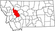 | |
| Town | ||
| CDPs | ||
| Other unincorporated communities | ||
This article is issued from Wikipedia - version of the 8/17/2014. The text is available under the Creative Commons Attribution/Share Alike but additional terms may apply for the media files.