Seaforth, Queensland
| Seaforth Queensland | |||||||
|---|---|---|---|---|---|---|---|
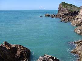 View in Seaforth | |||||||
 Seaforth | |||||||
| Coordinates | 20°54′6″S 148°57′59″E / 20.90167°S 148.96639°ECoordinates: 20°54′6″S 148°57′59″E / 20.90167°S 148.96639°E | ||||||
| Population | 613 (2006 census)[1] | ||||||
| Established | 1899 | ||||||
| Postcode(s) | 4741 | ||||||
| Elevation | 10 m (33 ft) | ||||||
| Location | 35 km (22 mi) North-northwest of Mackay, Queensland | ||||||
| LGA(s) | Mackay Regional Council | ||||||
| State electorate(s) | Mackay | ||||||
| Federal Division(s) | Dawson | ||||||
| |||||||
Seaforth is a small coastal holiday and fishing town located 35 kilometres (22 mi) North-northwest of Mackay. In 1899 the Queensland Government bought Seaforth Estate from H.M. Finlayson as a settlement and named it Springcliff, however local residents always called it Seaforth and it was officially renamed in 1966.[2] At the 2006 census, Seaforth had a population of 613.[1]
External links
References
- 1 2 Australian Bureau of Statistics (25 October 2007). "Seaforth (L) (Urban Centre/Locality)". 2006 Census QuickStats. Retrieved 25 June 2011.
- ↑ http://education.qld.gov.au/projects/educationviews/signpost/2009/seaforth-ss.html
This article is issued from Wikipedia - version of the 7/19/2016. The text is available under the Creative Commons Attribution/Share Alike but additional terms may apply for the media files.