Sellersville, Pennsylvania
| Borough of Sellersville | |
| Borough | |
 Main Street | |
| Country | United States |
|---|---|
| State | Pennsylvania |
| County | Bucks |
| Elevation | 381 ft (116.1 m) |
| Coordinates | 40°21′31″N 75°18′36″W / 40.35861°N 75.31000°WCoordinates: 40°21′31″N 75°18′36″W / 40.35861°N 75.31000°W |
| Area | 1.2 sq mi (3.1 km2) |
| - land | 1.2 sq mi (3 km2) |
| - water | 0.04 sq mi (0 km2), 3.33% |
| Population | 4,249 (2010) |
| Density | 3,934.1/sq mi (1,519.0/km2) |
| Timezone | EST (UTC-5) |
| - summer (DST) | EDT (UTC-4) |
| ZIP code | 18960 |
| Area code | 215 267 |
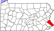
 Location of Sellersville in Bucks County | |
 Location of Sellersville in Pennsylvania | |
 Location of Pennsylvania in the United States | |
Sellersville is a borough in Bucks County, Pennsylvania, United States. The population was 4,249 at the 2010 census. Sellersville is part of Pennridge School District.
History
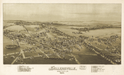
Sellersville was founded in the early 18th century. It was centered on a major road known as Bethlehem Pike that connected Philadelphia to Bethlehem and the rest of what was then far Western Pennsylvania. The town was very small and was called Sellers Tavern. Its most notable feature was a large inn. The present Washington House in Sellersville, however, was not Sellers Tavern. The town grew slowly over the years until the Industrial Revolution. In the 1860s the North Pennsylvania Railroad was built, running parallel to Bethlehem Pike: this stimulated the growth of light textile industries and brought a wave of population growth. The East Branch of the Perkiomen Creek runs through the town which connects it to an adjacent town of Perkasie. This creek was dammed in the early 20th century creating a small body of water known as Lake Lenape. Along the length of the lake a park was built on Perkasie and Sellersville lands. In the 1920s and 1930s this park housed a carousel, a roller coaster and several other amusements. The railroad brought hundreds of people from Philadelphia in the summer time, and it became a well known vacation spot for blue collar city workers. The town was also home to the Radium Company of America, which was the largest uranium milling facility in the world at the time. The United States Gauge Company originated in Sellersville in 1904 and became a prominent manufacturer of gauges for military use, many of which were coated with radium-based paint[1] for nighttime luminesence. The company later became instrumental in the production of nuclear weapons,[2] leaving behind a legacy of industrial and radioactive contamination that has been well-hidden by local, county, state, and federal government agencies for decades.[3][4][5][6][7][8][9][10][11] Today the town is still relatively small, sandwiched in between a ridge line and the larger town of Perkasie. The center of town still runs along Bethlehem Pike which is now called Old Route 309. The Washington House still stands and has recently been restored to become an upscale restaurant. Next door to the restaurant was a livery stable, which was converted into a theater (later a movie theater) in 1894. It has since been restored, and reopened in 2001 as Sellersville Theater 1894- a popular live music venue. The creek is still dammed but only the carousel in Perkasie remains of the amusements. The textile industry has long moved out of the area and Sellersville has become mainly a residential town for people working in the many urban centers that are only a short commute away. Grand View Hospital, Bucks County’s first hospital, has provided residents of Bucks and Montgomery counties with comprehensive healthcare services since 1913. The town is surrounded on three sides by open country and spread out housing developments. The local firehouse provides various activities throughout the year, including a carnival in the summer. The Holiday House Pool and Recreation Center becomes a hotspot for people to escape the heat during the summer as well. There are various business along Main Street one of which is the Washington House. This strip of businesses along Main Street provide some jobs as well, but largely the town remains a residential area. There is a Sellersville Museum off of Main Street which displays different exhibits every month.
The Teller Cigar Factory was listed on the National Register of Historic Places in 1987.[12]
Geography
According to the United States Census Bureau, the borough has a total area of 1.2 square miles (3.1 km2), of which, 1.2 square miles (3.1 km2) of it is land and 0.04 square miles (0.10 km2) of it (1.69%) is water. It is located in Southeastern Pennsylvania as part of Northern Bucks County (colloquially referred to as Upper Bucks) which borders Northampton County,and Lehigh County.
Demographics
| Historical population | |||
|---|---|---|---|
| Census | Pop. | %± | |
| 1880 | 490 | — | |
| 1890 | 794 | 62.0% | |
| 1900 | 1,247 | 57.1% | |
| 1910 | 1,572 | 26.1% | |
| 1920 | 1,739 | 10.6% | |
| 1930 | 2,063 | 18.6% | |
| 1940 | 2,115 | 2.5% | |
| 1950 | 2,373 | 12.2% | |
| 1960 | 2,497 | 5.2% | |
| 1970 | 2,829 | 13.3% | |
| 1980 | 3,143 | 11.1% | |
| 1990 | 4,479 | 42.5% | |
| 2000 | 4,564 | 1.9% | |
| 2010 | 4,249 | −6.9% | |
| Est. 2015 | 4,212 | [13] | −0.9% |
| Sources:[14][15][16] | |||
As of the census[15] of 2010, there were 4,249 people residing in the borough. The racial makeup of the borough was 93.6% White, 1.8% African American, 0.3% Native American, 1.0% Asian, 0.0% Pacific Islander, 1.0% from other races, and 2.3% from two or more races. Hispanic or Latino of any race were 3.4% of the population.
As of the census[15] of 2000, there were 4,564 people, 1,770 households, and 1,198 families residing in the borough. The population density was 3,934.1 people per square mile (1,519.1/km²). There were 1,827 housing units at an average density of 1,574.8 per square mile (608.1/km²). The racial makeup of the borough was 97.30% White, 0.57% African American, 0.15% Native American, 0.35% Asian, 0.04% Pacific Islander, 0.48% from other races, and 1.10% from two or more races. Hispanic or Latino of any race were 1.99% of the population.
There were 1,770 households, out of which 36.8% had children under the age of 18 living with them, 53.1% were married couples living together, 11.0% had a female householder with no husband present, and 32.3% were non-families. 26.5% of all households were made up of individuals, and 5.9% had someone living alone who was 65 years of age or older. The average household size was 2.56 and the average family size was 3.13.
In the borough the population was spread out, with 27.6% under the age of 18, 8.2% from 18 to 24, 36.9% from 25 to 44, 19.1% from 45 to 64, and 8.2% who were 65 years of age or older. The median age was 34 years. For every 100 females there were 101.1 males. For every 100 females age 18 and over, there were 95.9 males.
The median income for a household in the borough was $46,500, and the median income for a family was $55,313. Males had a median income of $38,018 versus $27,056 for females. The per capita income for the borough was $19,970. About 5.4% of families and 5.2% of the population were below the poverty line, including 6.5% of those under age 18 and 5.6% of those age 65 or over.
Notable people
Notable current and former residents of Sellersville include:
- Beverly Lynne, Adult film star
- Kyle Blanks, Major League Baseball outfielder, of the Texas Rangers
- Walter Emerson Baum, noted Pennsylvania impressionist painter and art educator
- Chris Collingwood, co-founder of the power pop band, Fountains of Wayne[17]
- Jamie Moyer, Major League Baseball pitcher
Transportation
Sellersville was once served by the SEPTA Bethlehem Line.
References
- ↑ Ferry, Joseph P., “DEP to Begin Cleanup in Sellersville; 3,000 Cubic Yards of Soil Contaminated by Radioactivity Will Be Excavated in a $1.7 Million Project,” Allentown Morning Call, August 16, 1996, http://articles.mcall.com/1996-08-16/news/3105359_1_radium-contaminated-goldberg.
- ↑ Etheridge, A.C., "Engineer Recalls First Visit to White Room," Perkasie News Herald, October 28, 1992.
- ↑ Duhigg, C., Ericson, M., Evans, T., Hamman, B., Willis, D. “Toxic Waters.” New York Times. December 16, 2009. Published testing data from Sellersville Boro Water Works obtained by the Environmental Working Group exposed serious industrial contamination of Sellersville's municipal water supply that had been removed from all public disclosure provided by Sellersville Borough, the Bucks County Department of Health, the Pennsylvania Department of Environmental Protection, and the United States Environmental Protection Agency throughout each entity's oversight of said water supplier.
- ↑ Halliburton Nuclear Utility Services Environmental Corporation. “Final Screening Site Inspection – Inactive Landfill – EPA Work Assignment No. 37-34-3JZZ.” June 16, 1992. Retrieved December 19, 2014 via FOIA Appeal #EPA-HQ-2014-010618 submitted on September 22, 2014, mandating the provision of information requested initially in FOIA Request #EPA-R3-2014-006974 submitted on June 2, 2014. Said report was provided upon appeal...with 58 of its 60 pages fully redacted: https://www.slideshare.net/secret/5sydRQLjXyj4cN .
- ↑ Pennsylvania Department of Environmental Protection. Commonwealth of Pennsylvania: Department of Environmental Resources vs. PTI. p. 28-29, 67. Bucks County Court of Common Pleas No. 94-007754-15-5. 17 October 1994. Retrieved 2012 via Freedom of Information Act Request. Litigation regarding high-level radiation contamination in Sellersville, Pennsylvania which references the aforesaid Halliburton “Final Screening Site Inspection – Inactive Landfill” report that was redacted in full by the USEPA upon its provision in appeal. Page 28-29 of the legal transcript indicates that said report was to be withheld from inclusion in the court's records: “I'm not going to have this marked for the record, Your Honor, if you don't mind. I'm not sure we want it in the record;” Page 67 indicates that radioactive “hot spots” are located “all over Sellersville.” The aforesaid Halliburton “Final Screening Site Inspection – Inactive Landfill” report designates the location of these areas. This report continues to be withheld from the general public, having been 1) omitted from Bucks County court records, 2) eliminated from the PADEP's FOIA request provision, 3) deemed denied by Sellersville Borough in a 3/2014 FOIA request, 4) deemed denied by the USEPA in a 6/2014 FOIA request, and 5) provided in a subsequent 2014 USEPA FOIA appeal, but with 58 of its 60 pages fully redacted (blackened-out). The USEPA issued a letter on 4/1/2016 to reiterate that said redaction was made to protect “geological and geophysical information and data, including maps regarding wells” from public disclosure, and to advise that the rest of the appeal pertaining to radiation issues in Sellersville, Pennsylvania was denied due to various regulations protecting the disclosure of confidential business information (“CBI”), government contract information, and information about individuals in “medical and similar files.”
- ↑ Pennsylvania Department of Environmental Protection. Administrative Record – AMETEK U.S. Gauge Division, Sellersville, PA. Reporting shows the drilling of groundwater monitoring wells per the directive of the USEPA at AMETEK Plant #2 as bypassing the confined aquifer containing the underground chemical plume and extracting from the confined aquifer beneath where the chemical plume contamination is not present. This creates testing results within “acceptable” range for human health/exposure and is inclusive of wells drilled by AMETEK on the grounds of an adjacent residential subdivision. Retrieved 2012 via Freedom of Information Act Request. Reference page 18: https://www.slideshare.net/secret/9swclB48uWVxl3 .
- ↑ Pennsylvania Department of Environmental Protection. Internal Memorandum (excerpt) dated January 22, 2014 acknowledging radiation issues at AMETEK Plant #2, Sellersville, PA. Said issues continue to be denied by Sellersville Borough, Bucks County, and the United States Environmental Protection Agency. Retrieved November 20, 2014 via Freedom of Information Act Request. Reference page 1, highlighted: https://www.slideshare.net/secret/BOVOX3S34Yf7jR .
- ↑ United States Census Bureau, 1920. “Home Farm” is listed as the industry for individuals residing at 215 Diamont Street in Sellersville Borough, Bucks County, Pennsylvania. Said description was written over the words “Radium Plant” on Sheet 2A, Line 14 of this federal document. Reference addendum 7, page 8: http://www.slideshare.net/Ax318960/freedom-of-information-request-sellersville-borough-1816 .
- ↑ “Sellersville Proud of Its Fame as Home of Big Plant that Now Produces Radium.” Author Unknown. Trenton Evening Times. January 8, 1914. Additional information and newspaper citations: http://www.slideshare.net/Ax318960/trenton-evening-times-january-8-1914 .
- ↑ “U.S. Material Safety Data Sheet - AMETEK U.S. Gauge, Sellersville, PA.” United States National MSDS Repository. Retrieved May 2, 2016. A Material Safety Data Sheet (MSDS) is an informational document of a hazardous chemical or product that a manufacturer has produced at its facility which describes its physical and chemical properties, hazards, and recommended precautions for handling, storage and disposal. A 2016 search of national MSDS archives revealed a previously unseen MSDS for product “AW1 7-8 2OUF2,” otherwise known as “Radium 226,” with the producer/manufacturer for said product listed as “AMETEK U.S. Gauge, 900 Clymer Ave., Sellersville, PA.” Reference: http://www.slideshare.net/Ax318960/ametek-us-gauge-manufacturer-of-radium-226 .
- ↑ “WPA Real Estate Survey Reveals Property Line Discrepancies.” Author and Newspaper Unknown. January 24, 1936. Article obtained from the Mercer Museum Library, Doylestown, PA. Additional information: http://www.slideshare.net/Ax318960/removed-posts-and-final-commentary .
- ↑ National Park Service (2010-07-09). "National Register Information System". National Register of Historic Places. National Park Service.
- ↑ "Annual Estimates of the Resident Population for Incorporated Places: April 1, 2010 to July 1, 2015". Retrieved July 2, 2016.
- ↑ "Census of Population and Housing". U.S. Census Bureau. Retrieved 11 December 2013.
- 1 2 3 "American FactFinder". United States Census Bureau. Retrieved 2008-01-31.
- ↑ "Incorporated Places and Minor Civil Divisions Datasets: Subcounty Resident Population Estimates: April 1, 2010 to July 1, 2012". Population Estimates. U.S. Census Bureau. Retrieved 11 December 2013.
- ↑ Wise, Brian. "Eclectic Sounds of New Jersey, Echoing From Coast to Coast", The New York Times, February 8, 2004. Accessed November 22, 2007.
| Wikimedia Commons has media related to Sellersville, Pennsylvania. |