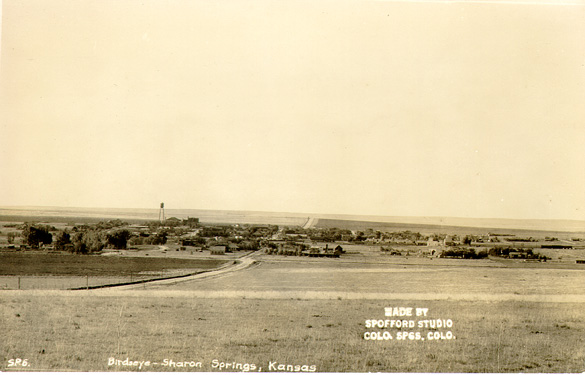
Sharon Springs, Kansas
| Sharon Springs, Kansas | |
|---|---|
| County seat | |
|
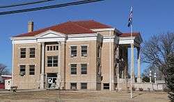
Wallace County Courhouse (2010) | |
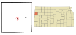 Location within Wallace County and Kansas | |
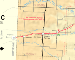 KDOT map of Wallace County (legend) | |
| Coordinates: 38°53′44″N 101°45′3″W / 38.89556°N 101.75083°WCoordinates: 38°53′44″N 101°45′3″W / 38.89556°N 101.75083°W | |
| Country | United States |
| State | Kansas |
| County | Wallace |
| Area[1] | |
| • Total | 0.91 sq mi (2.36 km2) |
| • Land | 0.91 sq mi (2.36 km2) |
| • Water | 0 sq mi (0 km2) |
| Elevation | 3,474 ft (1,059 m) |
| Population (2010)[2] | |
| • Total | 748 |
| • Estimate (2015)[3] | 761 |
| • Density | 820/sq mi (320/km2) |
| Time zone | Mountain (MST) (UTC-7) |
| • Summer (DST) | MDT (UTC-6) |
| ZIP code | 67758 |
| Area code(s) | 785 |
| FIPS code | 20-64375 [4] |
| GNIS feature ID | 0471157 [5] |
| Website | City Website |
Sharon Springs is a city in and the county seat of Wallace County, Kansas, United States.[6] As of the 2010 census, the city population was 748.[7]
History
Sharon Springs was originally called Eagle Tail Station when it was founded in 1868. It was renamed Sharon Springs in 1886, after Sharon Springs, New York.[8][9] Sharon Springs was incorporated as a city in 1890.[10]
In 2013, the largest sinkhole in Kansas opened north of Sharon Springs. As of December 2013, the sinkhole was approximately 88 feet (27 m) deep and 243 feet (74 m) across.[11]
Geography
Sharon Springs is located at 38°53′44″N 101°45′3″W / 38.89556°N 101.75083°W (38.895513, -101.750881).[12] According to the United States Census Bureau, the city has a total area of 0.91 square miles (2.36 km2), all land.[1]
Climate
According to the Köppen Climate Classification system, Sharon Springs has a semi-arid climate, abbreviated "BSk" on climate maps.[13]
Demographics
| Historical population | |||
|---|---|---|---|
| Census | Pop. | %± | |
| 1890 | 178 | — | |
| 1900 | 180 | 1.1% | |
| 1910 | 440 | 144.4% | |
| 1920 | 815 | 85.2% | |
| 1930 | 792 | −2.8% | |
| 1940 | 760 | −4.0% | |
| 1950 | 994 | 30.8% | |
| 1960 | 966 | −2.8% | |
| 1970 | 1,012 | 4.8% | |
| 1980 | 982 | −3.0% | |
| 1990 | 872 | −11.2% | |
| 2000 | 835 | −4.2% | |
| 2010 | 748 | −10.4% | |
| Est. 2015 | 761 | [3] | 1.7% |
| U.S. Decennial Census | |||
2010 census
As of the census[2] of 2010, there were 748 people, 327 households, and 197 families residing in the city. The population density was 822.0 inhabitants per square mile (317.4/km2). There were 407 housing units at an average density of 447.3 per square mile (172.7/km2). The racial makeup of the city was 94.5% White, 0.1% African American, 0.4% Native American, 3.6% from other races, and 1.3% from two or more races. Hispanic or Latino of any race were 5.7% of the population.
There were 327 households of which 27.2% had children under the age of 18 living with them, 51.7% were married couples living together, 6.1% had a female householder with no husband present, 2.4% had a male householder with no wife present, and 39.8% were non-families. 38.2% of all households were made up of individuals and 22.3% had someone living alone who was 65 years of age or older. The average household size was 2.23 and the average family size was 2.99.
The median age in the city was 45.3 years. 25.5% of residents were under the age of 18; 4.9% were between the ages of 18 and 24; 19.2% were from 25 to 44; 25.4% were from 45 to 64; and 25% were 65 years of age or older. The gender makeup of the city was 48.8% male and 51.2% female.
2000 census
As of the census[4] of 2000, there were 835 people, 354 households, and 227 families residing in the city. The population density was 900.0 people per square mile (346.7/km²). There were 408 housing units at an average density of 439.8 per square mile (169.4/km²). The racial makeup of the city was 96.05% White, 0.24% African American, 0.48% Native American, 1.68% from other races, and 1.56% from two or more races. Hispanic or Latino of any race were 4.31% of the population.
There were 354 households out of which 29.7% had children under the age of 18 living with them, 57.3% were married couples living together, 3.7% had a female householder with no husband present, and 35.6% were non-families. 33.9% of all households were made up of individuals and 17.8% had someone living alone who was 65 years of age or older. The average household size was 2.29 and the average family size was 2.93.
In the city the population was spread out with 24.2% under the age of 18, 7.9% from 18 to 24, 22.5% from 25 to 44, 21.3% from 45 to 64, and 24.1% who were 65 years of age or older. The median age was 42 years. For every 100 females there were 90.2 males. For every 100 females age 18 and over, there were 95.4 males.
The median income for a household in the city was $33,333, and the median income for a family was $43,684. Males had a median income of $27,500 versus $14,600 for females. The per capita income for the city was $17,656. About 4.3% of families and 7.3% of the population were below the poverty line, including 6.7% of those under age 18 and 10.8% of those age 65 or over.
Transportation
Sharon Springs is located on U.S. Route 40.
References
- 1 2 "US Gazetteer files 2010". United States Census Bureau. Retrieved 2012-07-06.
- 1 2 "American FactFinder". United States Census Bureau. Retrieved 2012-07-06.
- 1 2 "Annual Estimates of the Resident Population for Incorporated Places: April 1, 2010 to July 1, 2015". Retrieved July 2, 2016.
- 1 2 "American FactFinder". United States Census Bureau. Retrieved 2008-01-31.
- ↑ "US Board on Geographic Names". United States Geological Survey. 2007-10-25. Retrieved 2008-01-31.
- ↑ "Find a County". National Association of Counties. Retrieved 2011-06-07.
- ↑ "2010 City Population and Housing Occupancy Status". U.S. Census Bureau. Retrieved March 27, 2011.
- ↑ Kansas State Historical Society (1916). Biennial Report of the Board of Directors of the Kansas State Historical Society. Kansas State Printing Plant. p. 310.
- ↑ "Profile for Sharon Springs, Kansas". ePodunk. Retrieved 27 June 2014.
- ↑ Blackmar, Frank Wilson (1912). Kansas: A Cyclopedia of State History, Volume 2. Standard Publishing Company. p. 682.
- ↑ "Kansas Sinkhole". UPI. Retrieved 2013-08-04.
- ↑ "US Gazetteer files: 2010, 2000, and 1990". United States Census Bureau. 2011-02-12. Retrieved 2011-04-23.
- ↑ Climate Summary for Sharon Springs, Kansas
Further reading
- History of the State of Kansas; William G. Cutler; A.T. Andreas Publisher; 1883. (Online HTML eBook)
- Kansas : A Cyclopedia of State History, Embracing Events, Institutions, Industries, Counties, Cities, Towns, Prominent Persons, Etc; 3 Volumes; Frank W. Blackmar; Standard Publishing Co; 944 / 955 / 824 pages; 1912. (Volume1 - Download 54MB PDF eBook),(Volume2 - Download 53MB PDF eBook), (Volume3 - Download 33MB PDF eBook)
External links
| Wikimedia Commons has media related to Sharon Springs, Kansas. |
- City
- City of Sharon Springs
- Sharon Springs - Directory of Public Officials
- Wallace County, Wallace County economic development alliance
- Wallace County, skyways.lib.ks.us
- Sharon Springs and Wallace County, kansastowns.us
- Schools
- USD 241, local school district
- Historic
- Maps
- Sharon Springs City Map, KDOT
Municipalities and communities of Wallace County, Kansas, United States | ||
|---|---|---|
| Cities |  | |
| CDP | ||