Shawmut, Montana
| Shawmut, Montana | |
|---|---|
| Census-designated place | |
 Shawmut, Montana | |
| Coordinates: 46°20′33″N 109°31′30″W / 46.34250°N 109.52500°WCoordinates: 46°20′33″N 109°31′30″W / 46.34250°N 109.52500°W | |
| Country | United States |
| State | Montana |
| County | Wheatland |
| Area[1] | |
| • Total | 2.146 sq mi (5.56 km2) |
| • Land | 2.146 sq mi (5.56 km2) |
| • Water | 0 sq mi (0 km2) |
| Elevation | 3,855 ft (1,175 m) |
| Population (2010)[2] | |
| • Total | 42 |
| • Density | 20/sq mi (7.6/km2) |
| Time zone | Mountain (MST) (UTC-7) |
| • Summer (DST) | MDT (UTC-6) |
| ZIP code | 59078 |
| Area code(s) | 406 |
| GNIS feature ID | 806804[3] |
Shawmut is a census-designated place and unincorporated community in Wheatland County, Montana, United States. Its population was 42 as of the 2010 census.[2] Shawmut has a post office with ZIP code 59078, which opened on October 27, 1885.[4][5] The community is located along U.S. Route 12 and Montana Highway 3.
References
- ↑ "US Gazetteer files: 2010, 2000, and 1990". United States Census Bureau. 2011-02-12. Retrieved 2011-04-23.
- 1 2 "American FactFinder". United States Census Bureau. Retrieved 2011-05-14.
- ↑ "Shawmut". Geographic Names Information System. United States Geological Survey.
- ↑ United States Postal Service (2012). "USPS - Look Up a ZIP Code". Retrieved 2012-02-15.
- ↑ "Postmaster Finder - Post Offices by ZIP Code". United States Postal Service. Retrieved August 1, 2013.
Municipalities and communities of Wheatland County, Montana, United States | ||
|---|---|---|
| Cities | 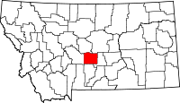 | |
| CDP | ||
| Unincorporated community | ||
This article is issued from Wikipedia - version of the 7/31/2014. The text is available under the Creative Commons Attribution/Share Alike but additional terms may apply for the media files.