Sherman Township, Clay County, Kansas
| Sherman Township | |
|---|---|
| Township | |
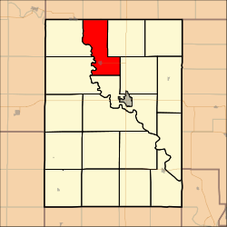 Location in Clay County | |
| Coordinates: 39°28′30″N 097°11′21″W / 39.47500°N 97.18917°WCoordinates: 39°28′30″N 097°11′21″W / 39.47500°N 97.18917°W | |
| Country | United States |
| State | Kansas |
| County | Clay |
| Area | |
| • Total | 33.33 sq mi (86.33 km2) |
| • Land | 33 sq mi (85.46 km2) |
| • Water | 0.33 sq mi (0.87 km2) 1.01% |
| Elevation | 1,234 ft (376 m) |
| Population (2000) | |
| • Total | 328 |
| • Density | 9.9/sq mi (3.8/km2) |
| GNIS feature ID | 0473356 |
Sherman Township is a township in Clay County, Kansas, USA. As of the 2000 census, its population was 328.
Geography
Sherman Township covers an area of 33.33 square miles (86.3 km2) and contains one incorporated settlement, Morganville. According to the USGS, it contains two cemeteries: Morganville and Sherman.
Stillwater Lake is within this township. The streams of East Branch Dry Creek and Peats Creek run through this township.
References
External links
Municipalities and communities of Clay County, Kansas, United States | ||
|---|---|---|
| Cities | 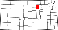 | |
| Unincorporated communities | ||
| Townships | ||
| Footnotes | ‡This populated place also has portions in an adjacent county or counties | |
This article is issued from Wikipedia - version of the 11/11/2013. The text is available under the Creative Commons Attribution/Share Alike but additional terms may apply for the media files.