Shires of Scotland

The counties or shires of Scotland (Scottish Gaelic: Siorrachdan na h-Alba) are geographic subdivisions of Scotland established in the Middle Ages. They ceased to be used for local government purposes after 1975 under the Local Government (Scotland) Act 1973.[1]
Today, local government in Scotland is based upon "council areas", which sometimes incorporate county names, but frequently have vastly different boundaries. Counties continue to be used for the purpose of lieutenancy and land registration purposes,[2] though the lieutenancy areas are not entirely identical.[3]
Origin
Sheriffdoms or shires
Malcolm III (reigned 1058 to 1093) appears to have introduced sheriffs as part of a policy of replacing previous forms of government with Norman feudal structures.[4]
This policy was continued by Edgar (reigned 1097 to 1107), Alexander I (reigned 1107 to 1124), and in particular David I (reigned 1124 to 1153). David completed the division of the country into sheriffdoms by the conversion of existing thanedoms.[5] The earliest sheriffdom south of the Forth which we know of for certain is Haddingtonshire, which is named in a charters of 1139 as Hadintunschira[6] and in another of 1141 as Hadintunshire.[7] Stirlingshire appears in a charter of 1150 under the name Striuelinschire.[8]
The shires of the Highlands were completed only in the reign of King Charles I (reigned 1625 to 1649).
Shires extant by 1305
In 1305 Edward I of England, who had deposed John Balliol issued an Ordinance for the Government of Scotland. The document listed the twenty-three shires then existing and either appointed new sheriffs or continued heritable sheriffs in office.[5]
- Aberdeen
- Ayr (Divided into the Bailieries of Carrick, Cunninghame and Kyle)
- Banff
- Berwick (Dependent on the governor of Berwick Castle)
- Clackmannan
- Cromarty (Had been formed by 1266, covering only the area immediately surrounding Cromarty.)
- Dunbarton
- Dumfries
- Edinburgh
- Elgin and Forres
- Fife
- Forfar
- Haddington
- Inverness
- Kincardine or the Mearns
- Kinross
- Lanark (Included what later became Renfrewshire)
- Linlithgow
- Peebles
- Perth
- Roxburgh or Teviotdale (Appears to have been created in the period 1114–1133).a
- Selkirk
- Stirling
- Wigtown
^Note a : Gospatric was mentioned as sheriff in a number of charters of Earl David.[9][10] The shire was not listed in the ordinance, and in 1305 appears to have been partly under the jurisdiction of the Sheriff of Selkirk, with the remainder comprised in the constabularies of Jedburgh and Roxburgh under the jurisdiction of the constable of Berwick.[11] The shire was one of those surrendered to Edward III of England in 1334.[12]
Shires formed after 1305
The remaining shires were formed either by the territorial expansion of the Kingdom of Scotland, or by the subdivision of existing sheriffdoms. Many of the new shires had highly irregular boundaries or detached parts as they united the various possessions of the heritable sheriffs.
- c.1326: Argyll (or Argyle): lordship subdued by Alexander II in 1222. Norwegian claims over the area finally ended in 1266. First record of appointment of sheriff dates from 1326.[13]
- 1369: Kirkcudbright formed when area between Rivers Nith and Cree granted to Archibald the Grim. Archibald appointed a steward to administer the area, hence it became a "stewartry".[14]
- c.1388: Bute. The islands formed part of Kintyre district of Argyll. A heritable sheriff was appointed to the shire in 1388.
- 1402: Renfrew: separated from the Shire of Lanark by Robert III.[15]
- 1503: Ross formed from part of Argyll by act of 1503. The Barony of Tarbert was annexed to Cromarty in 1685, but later returned.
- 1503: Caithness: Separated from the Shire of Inverness by act of 1503 during the reign of James IV. Under the legislation the sheriff of Caithness was to sit at Dornoch and Wick, and the area of the sheriffdom was to be identical to that of the Diocese of Caithness.
- 1581: Orkney was erected into a lordship with the right of sheriffship. It was annexed to the Crown in 1612, although the term "lordship" continued to be applied to the area.[16]
- 1633: Sutherland separated from Inverness.b
^Note b : In 1583 the Earl of Huntly, hereditary sheriff of Inverness, granted the Earl of Sutherland jurisdiction over the sheriffdom of Sutherland and Strathnaver. This was only the south-eastern area of the later county, with Halladale River forming the boundary. The shire was formed in 1631 by Crown Writ of Charles I, severing Sutherland from Inverness. The new county comprised the Earldom of Sutherland along with Assynt and the baronies between Ross and Caithness. Dornoch was appointed the head burgh of the shire. The writ was confirmed by the Parliament of Scotland in 1633.[17]
The 1707 Act of Union and the ending of heritable jurisdictions
Following the union of Scotland with England, the government began bringing Scotland's local governance into line with the rest of Great Britain. The full machinery of county government was not immediately established, largely due to the fact that the office of sheriff or steward had become hereditary in certain families in the majority of sheriffdoms. At the accession of George II twenty-two sheriffs were hereditary, three were appointed for life and only eight held office at the pleasure of the monarch. The heritable sheriffdoms were Argyll, Bute, Banff, Caithness, Clackmannan, Cromarty, Dumbarton, Dumfries, Elgin, Fife, Kinross, Kirkcudbright, Linlithgow, Nairn, Orkney & Zetland, Peebles, Renfrew, Roxburgh, Selkirk, Sutherland, Stirling and Wigtown; those appointed for life were Perth, Forfar and Ayr; those held at pleasure were Aberdeen, Berwick, Edinburgh, Haddington, Inverness, Kincardine, Lanark and Ross.[18] Following the unsuccessful Jacobite Rising of 1745 the government took the opportunity of overhauling county government. The Heritable Jurisdictions Act 1747 revested the government of the shires in the Crown, compensating those office holders who were displaced. The Sheriffs (Scotland) Act 1747 reduced the office of sheriff principal to a largely ceremonial one, with a sheriff depute or sheriff substitute appointed to each "county, shire or stewartry". Twelve of the smallest counties were paired to form sheriffdoms, a process of amalgamation that was to continue until the twentieth century.[19] In 1794 Lord-Lieutenants were appointed to each county, and in 1797 county militia regiments were raised, bringing Scotland into line with England, Wales and Ireland.
Names and terminology
Names
In official documents shires were referred to as the Shire of X, rather than X Shire. The latter was more common in general usage. Thus in parliamentary proceedings one may find, for example, a heading referring to "Act for the shirrefdome of Dumbartane" but the text "the sevine kirkis to Dumbartane schyr"[20]
The first accurate county maps of Scotland appear in the late seventeenth century and contain a first-hand record of shire names. John Adair (maps c. 1682) gives the names of Midlothian, East Lothian, Twaddall and Wast Lothian (the latter also as "Linlithgowshire"[21]). The eighteenth century county maps of Herman Moll (dated c. 1745), preferred to keep the "Shire" suffix a separate word, as for example "Berwick Shire", "Roxburgh Shire", "the Shire of Selkirk otherwise known as Etterick Forest", and in the north to "Murray" (Moray), "Inverness Shire", "Aberdeen Shire", "Banff Shire", "Ross Shire".[22] The map of Boswell's and Johnson's A Journey to the Western Islands of Scotland (1773) gives "Shire" to every one shown, including "Angus Shire" and "Fife Shire".
Several shires have alternative names of long standing. These include:
- Angus – Forfarshire
- East Lothian – Haddingtonshire
- Kincardineshire – Mearns
- Midlothian – Edinburghshire
- Moray – Elginshire
- Peeblesshire – Tweeddale
- Roxburghshire - Teviotdale
- Selkirkshire – Ettrick Forest
- West Lothian – Linlithgowshire
In Scotland, as in England and Wales, the terms "shire" and "county" have been used interchangeably, with the latter becoming more common in later usage. Today, "county" is more commonly used, with "shire" being seen as a more poetic or archaic variant.
Counties until 1890
| Counties of Scotland until 1890 | |
|---|---|
 | |
It may be noted that the map depicts a large number of exclaves physically detached from the county that they were politically deemed to be part of. Cromartyshire's borders, a particularly fragmentary example, were achieved as late as 1685, although at that time the word "county" was not applied to the sheriffdom.
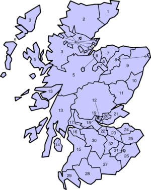
Counties from 1890 to 1975
| Counties of Scotland from 1890 to 1975 | |
|---|---|
|
|
Local government
From the 17th century the shires (counties) started to be used for local administration apart from judicial functions. In 1667 Commissioners of Supply were appointed in each sheriffdom to collect the land tax.[23] The commissioners eventually assumed other duties in the county.
In 1858 police forces were established in each county under the Police (Scotland) Act 1857. It should be noted, however, that burghs were largely outside the jurisdiction of county authorities.
Under the Local Government (Scotland) Act 1889, thirty-four county councils were formed. The areas governed by these councils, referred to as "administrative counties", resembled the traditional shires of Scotland, but not entirely. Exclaves were abolished, with the exception of one exclave of Dunbartonshire. Ross-shire and Cromartyshire were merged into Ross and Cromarty, and four cities - Aberdeen, Dundee, Edinburgh and Glasgow - were made counties in their own right. These "counties of cities" were periodically expanded, as their urban areas spread further and further into the surrounding countryside. In general, they were still considered part of the wider geographical county; for instance, Glasgow was still reckoned part of Lanarkshire, though it was no longer within the jurisdiction of Lanark County Council.
Under the Local Government (Scotland) Act 1929, two pairs of councils were combined with each other to form the "joint county councils" of Perth & Kinross and Moray & Nairn. Though governed by the same council, each county remained nominally independent from the other.
In 1963 the Government published a white paper which proposed a reduction in the number of counties from thirty-three to between ten and fifteen.[24] A process of consultation between county councils and officials from the Scottish Office was begun to affect the amalgamations. Following a change of government, it was announced in 1965 that a "more comprehensive and authoritative" review of local government areas would be undertaken.[25]
In 1966 a Royal Commission on Local Government in Scotland, chaired by Lord Wheatley was appointed.[26] The commission's report in 1969 recommended the replacement of the counties with larger regions.[27]
In 1970 another change in government control was followed by the publication of a white paper in 1971 implementing the commission's reforms in a modified form.[28] The abolition of counties "for local government purposes" was enacted by the Local Government (Scotland) Act 1973, with counties playing no part in local government after 16 May 1975, being replaced by regions and districts.
Local government was reorganised again under the Local Government etc. (Scotland) Act 1994, with the regions and districts being replaced by the currently existing council areas. These councils are unitary, meaning they undertake all local governance within their area, though "community councils" do operate in several towns.
See also
- List of Local Government Areas in Scotland (1930-75)
- History of local government in the United Kingdom
- List of counties of Scotland in 1951 by population and by area
- List of counties of Scotland in 1971 by population
- List of Scottish counties by highest point
- List of burghs in Scotland
- Local government areas of Scotland 1973 to 1996
- Lieutenancy areas of Scotland
- Subdivisions of Scotland
- List of places in Scotland
- Counties of the United Kingdom
References
- ↑ "Counties and Burghs". National Records of Scotland. Retrieved 2016-04-11.
- ↑ Land Register Counties & Operational Dates
- ↑ County Directory of Scotland. https://archive.org/details/countydirectoryo1875edin
- ↑ John of Fordun wrote that Malcolm II introduced the shire to Scotland and also the thane class. Shires are certainly mentioned in charters by the reign of Malcolm III, for instance that to the Church of Dunfermline, AD 1070-1093
- 1 2 Wallace, James (1890). The Sheriffdom of Clackmannan. A sketch of its history with a list of its sheriffs and excerpts from the records of court compiled from public documents and other authorities with preparatory notes on the office of Sheriff in Scotland, his powers and duties. Edinburgh: James Thin. pp. 7–19.
- ↑ Charter by King David to the church of St. Andrews of the church of St. Mary at Haddington
- ↑ Charter by King David granting Clerchetune to the church of St. Mary of Haddington
- ↑ Charter by King David granting the church of Clackmannan, etc., to the Abbey of Stirling
- ↑ Barrow, G. W. S., ed. (1999), The Charters of David I: The Writtens Acts of David King of Scots, 1124—53, and of his son Henry Earl of Northumberland, 1139—52, Woodbridge: Boydell Press, pp. 59–60, 69–70, ISBN 0-85115-731-9
- ↑ Reid, Norman H.; Barrow, G. W. S., eds. (2002), The Sheriffs of Scotland : An Interim List to C.1306, St Andrews: University of St. Andrews Library [on behalf of] The Scottish Medievalists, p. 37, ISBN 0-900897-17-1
- ↑ Kerr, Robert (1811). The History of Scotland during the Reign of Robert I. Edinburgh. p. 152.
- ↑ Barrell, Andrew D M (2000). Medieval Scotland. Edinburgh: Cambridge University Press. p. 127.
- ↑ MacNair, Peter (1914). Argyllshire and Buteshire. Cambridge County Geographies. London: Cambridge University Press. pp. 1, 69.
- ↑ Learmonth, William (1920). Kirkcudbrightshire and Wigtownshire. Cambridge County Geographies. London: Cambridge University Press. pp. 2–3.
- ↑ Mort, Frederick (1919). Renfrewshire. Cambridge County Geographies. London: Cambridge University Press. p. 3.
- ↑ Orkney and Zetland (Shetland) were generally treated as a single county, with Orkney being described an "Earldom" and Zetland being described as a "Lordship". They constituted a single Orkney and Shetland constituency in the House of Commons, as they had done in the Scots Parliament, and were counted together in the census.
- ↑ Campbell, H F (1920). Caithness & Sutherland. Cambridge County Geographies. Cambridge: Cambridge University Press. pp. 79–80.
- ↑ Whetstone, Ann E. "The Reform of the Scottish Sheriffdoms in the Eighteenth and Early Nineteenth Centuries". Albion: A Quarterly Journal Concerned with British Studies. The North American Conference on British Studies. 9 (1): 61–71. JSTOR 4048219.
- ↑ Whatley, Christopher A (2000). Scottish Society 1707-1820. Manchester University Press. p. 147. ISBN 978-0-7190-4540-0.
- ↑ Parliamentary Minutes, 13 November 1641.
- ↑ (1682) - John Adair – Mappe of Wast Lothian commonly called Linlithgowshire authore Johanne Adair; (manuscript in the National Library of Scotland)
- ↑ Manuscripts in the National Library of Scotland
- ↑ The sheriffdoms listed were Edinburgh (i.e. Midlothian), Hadingtoun (i.e. East Lothian), Berwick, Roxburgh, Selkirk, Peebles, Lanerk, Dumfreize, "the sherifdome of Wigtoun and stewartrie of Kirkcudbright", Air, Dumbartan, Bute, Renfrew, Striviling (i.e. Stirlingshire), Linlithgow (i.e. West Lothian), Perth, Kincairdine, Aberdene, Inverness and Ross, Nairne, Cromarty, Argyle, Fyfe and Kinross, Forfar (i.e. Angus), Bamf (i.e. Banff), Sutherland, Caithnes, Elgine (i.e Moray), Orkney and Zetland, Clakmannan. "Act of the convention of estates of the kingdome of Scotland etc. for ane new and voluntar offer to his majestie of seventie two thousand pounds monethlie for the space of twelve moneths". Records of the Parliaments of Scotland. University of St Andrews. 23 January 1667. Retrieved 23 July 2010.
- ↑ The Modernisation of Local Government in Scotland (Cmnd. 2067)
- ↑ Scots council reform plans changed, The Times, 6 March 1965
- ↑ Tasks set for planners of local government - Members of royal commissions named, The Times, 25 May 1966
- ↑ Report of the Royal Commission on Local Government in Scotland 1966 - 69 (Cmnd.4150)
- ↑ Reform of Local Government in Scotland (Cmnd. 4583)
External links
| Wikimedia Commons has media related to Shires of Scotland. |
| Wikimedia Commons has media related to Maps of traditional counties of Scotland. |
- The Historic Counties Trust
- Records of the Parliaments of Scotland
- The National Library of Scotland: Maps of Scotland
Scotland articles | |||||||||||||||||||
|---|---|---|---|---|---|---|---|---|---|---|---|---|---|---|---|---|---|---|---|
| History |
|  | |||||||||||||||||
| Geography | |||||||||||||||||||
| Politics |
| ||||||||||||||||||
| Economy | |||||||||||||||||||
| Society |
| ||||||||||||||||||
| |||||||||||||||||||