Pulau Ujong
| Native name: <span class="nickname" ">Pulau Ujong ڤولاو اوجوڠ | |
|---|---|
|
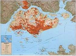
A map of Pulau Ujong | |
| Geography | |
| Location | Southeast Asia |
| Archipelago | Malay Archipelago |
| Adjacent bodies of water | South China Sea |
| Area | 710 km2 (270 sq mi) |
| Highest point | Bukit Timah Hill |
| Administration | |
| Demographics | |
| Population | 5,469,700 (2014)[1] |
| Pop. density | 7,618 /km2 (19,731 /sq mi) |
| Ethnic groups |
Chinese Singaporean Malay Singaporean Indian Singaporean |
Pulau Ujong (Malay: literally 'island at the end'), also known as Singapore Island or Mainland Singapore, is the main constituent island of Singapore. It is part of the Malay Archipelago and is located at the tip of Peninsular Malaysia. The island forms the majority of the country in terms of area and population as citizens are unable to reside in smaller islands of Singapore.[2] With a population of 5,469,700 and an area of 710 square kilometres, Pulau Ujong is the 21st most populous island in the world and the 31st most densely populated island in the world.[1]
Etymology
Pulau Ujong was the earliest reference to Singapore Island. Travellers from the Straits of Malacca to the South China Sea would have to pass through the island, hence the name Pulau Ujong. Like Johor's old name, Ujong Tanah meaning "Land's End", the island was known better by the Orang laut as Pulau Ujong literally meaning "End Island". The 3rd-century Chinese reference to Pu Luo Chung (蒲罗中)corresponds to the Malay reference known as Pulau Ujong.[3]
Legend
According to a third-century book Record of Foreign countries during the Eastern Wu Period (吴时外国传), Pu Luo Jong (Pulao Ujong) was inhabited by cannibals with five to six inch tails.[4]
Geography
The island measures 50 kilometres (31 mi) from east to west and 26 kilometres (16 mi) from north to south with 193 kilometres (120 mi) of coastline.[5] The highest point of Singapore is Bukit Timah Hill, with a height of 165 m (538 ft) and made up of igneous rock, granite. Hills and valleys of sedimentary rock dominate the northwest, while the eastern region consists of sandy and flatter land. Since 1822, there were land reclamation works by British, who at that time controlled the island and the government of Singapore has continued to increase the size of the island after independence, which increased the area of the island from 580 km2 (224 sq mi) in the 1960s to 710 km2 (274 sq mi) today.[6]
Extreme points
The northernmost end of the island is Sembawang. The westernmost and southernmost points are located at Tuas. The easternmost point of the island is Changi Bay.
References
- Citations
- 1 2 "2014 Population in Brief". Population SG. Retrieved March 1, 2015.
- ↑ "Pulau Ubin Stories". National University of Singapore. May 24, 2004.
- ↑ Xu Yunqiao History of South East Asia 1961 Singapore World Publishing Co. 许云樵 《南洋史》 星洲世界书局 1961年
- ↑ Record of Foreign Countries during the Eastern Wu Period, section on Pu Luo Jong 许云樵 《康泰吴时外国传辑注》 四十四-四十五页 1971 新加坡南洋研究所出版
- ↑ "Yearbook of Statistics Singapore 2012" (PDF). Department of Statistics Singapore. Retrieved 24 October 2012.
- ↑ Gillis, K., & Tan, K. (2006). The book of Singapore’s firsts (p. 96). Singapore: Singapore Heritage Society. Call no.: RSING 959.57 GIL-[HIS].
- Bibliography
- Victor R Savage; Brenda Yeoh (2004). Toponymics A Study of Singapore's Street Names. Eastern University Press. ISBN 981-210-364-3.
Coordinates: 1°22′N 103°48′E / 1.367°N 103.800°E