Slieve League
| Slieve League | |
|---|---|
| Sliabh Liag | |
 | |
| Highest point | |
| Elevation | 601 m (1,972 ft) |
| Listing | Marilyn |
| Geography | |
| Location | County Donegal, Ireland |
| OSI/OSNI grid | G544784 |
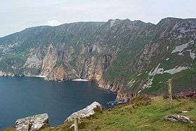
Slieve League, sometimes Slieve Leag or Slieve Liag (Irish: Sliabh Liag),[1] is a mountain on the Atlantic coast of County Donegal, Ireland. At 601 metres (1,972 ft), it has some of the highest sea cliffs on the island of Ireland.[2] Although less famous than the Cliffs of Moher in County Clare, Slieve League's cliffs reach almost three times higher.
The Belfast naturalist Robert Lloyd Praeger wrote in 1939:
A tall mountain of nearly 2000 feet, precipitous on its northern side, has been devoured by the sea till the southern face forms a precipice likewise, descending on this side right into the Atlantic from the long knife-edge which forms the summit. The traverse of this ridge, the "One Man's Path", is one of the most remarkable walks to be found in Ireland - not actually dangerous, but needing a good head and careful progress on a stormy day....The northern precipice, which drops 1500 feet into the coomb surrounding the Little Lough Agh, harbours the majority of the alpine plants of Slieve League, the most varied group of alpines to be found anywhere in Donegal.[3]
Road to viewpoint
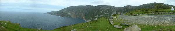
Slieve League panorama

Map of Slieve League
Slieve League is often photographed from a viewpoint known as Bunglass. It can be reached by means of a narrow road that departs from Teelin. The final few kilometers of this route is built along a precipice and includes several places where it turns at the crest of a rise.
Image gallery
 Slieve League's eastern end
 Extended view of eastern end of Slieve League
 One Man's Path
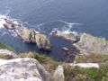 Looking down
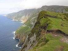 Across the top
See also
- Croaghaun, sea cliffs on the island Achill Island
References
| Wikimedia Commons has media related to Slieve League. |
- ↑ Marshall, David (2006). Best walks in Ireland. London: Frances Lincoln, p. 139. ISBN 978-0-7112-2420-9.
- ↑ "Road Tripping on Ireland's Wild Atlantic Way". Travel Addicts. 22 June 2014. Retrieved 25 July 2016.
- ↑ Praeger, Robert Lloyd (1997). The way that I went: an Irishman in Ireland. Cork: Collins Press, p. 41. ISBN 978-1-898256-35-9.
Coordinates: 54°38′17″N 8°40′53″W / 54.63806°N 8.68139°W
Mountains and hills of Ulster | ||
|---|---|---|
| Antrim Hills |  | |
| Antrim Plateau | ||
| Belfast Hills | ||
| Croaghgorms | ||
| Derryveagh | ||
| Inishowen | ||
| Mournes | ||
| Sperrins | ||
| Southwest Donegal | ||
| Others | ||
Lists of Marilyns | |
|---|---|
This article is issued from Wikipedia - version of the 8/7/2016. The text is available under the Creative Commons Attribution/Share Alike but additional terms may apply for the media files.