Blue Stack Mountains
This article is about the mountains in County Donegal. For the mountains in County Kerry, see
Stack's Mountains.
The Blue Stack Mountains[1] or Bluestack Mountains, also called the Croaghgorms (Irish: na Cruacha Gorma, meaning "the blue stacks"), are the major mountain range in the south of County Donegal, Ireland. They provide a barrier between the south of the county, such as Donegal Town and Ballyshannon, and the towns to the north and west such as Dungloe and Letterkenny. The road between the two parts of the county goes through the Barnesmore Gap.
The highest mountain in the range is Croaghgorm, which is 674 metres high. Nearby summits include Ardnageer (642 m), Croaghanirwore (548 m), Croaghbarnes (499 m), Croaghblane (641 m), Croaghnageer (571 m), Croveenananta (476 m), Gaugin Mountain (565 m), Lacroagh (403 m), Lavagh More (671 m) and Lavagh Beg (650 m).[2]
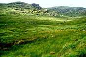
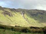
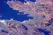
Pictures
| The Blue Stacks from earth orbit (top right) |
|
References
External links
Coordinates: 54°45′27″N 7°58′17″W / 54.75750°N 7.97139°W / 54.75750; -7.97139