Cuilcagh
| Cuilcagh | |
|---|---|
| Binn Chuilceach | |
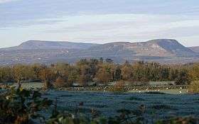
 View from Cuilcagh | |
| Highest point | |
| Elevation | 665 m (2,182 ft) |
| Prominence | 606 m (1,988 ft) |
| Listing | Marilyn, Hewitt |
| Naming | |
| Translation | calcareous/chalky peak (Irish) |
| Pronunciation | Irish: [bʲiːnʲ ˈxɪlʲcəx] |
| Geography | |
 Cuilcagh Location in Ireland | |
| Location | Fermanagh, Northern Ireland & Cavan, Republic of Ireland |
| OSI/OSNI grid | H123280 |
| Topo map |
OSi Discovery 26 |
| Designated | 31 December 1998 |
Cuilcagh (from Irish: Binn Chuilceach, meaning "chalky peak"[1]) is a mountain on the border between County Fermanagh (in Northern Ireland) and County Cavan (in the Republic of Ireland) (once part of the a medieval Kingdom of Breifne). With a height of 665 metres (2,182 ft) it is the highest point in both counties and the 165th highest on the island of Ireland.[2] Water from the southern slope flows underground until it emerges some miles away in the Shannon Pot, the traditional source of the River Shannon.
Name and history
The name Cuilcagh comes from the Irish Cuilceach, which has been translated as "chalky". However, the mountain is mainly sandstone and shale, covered with bog and heather. "It is possible that the name refers to the limestone rock on the lower northern flanks. Here a number of streams disappear below ground at swallow holes named Cats Hole, Pollawaddy, Pollasumera and Polliniska, all forming part of the Marble Arch cave system. If so, the name would mean 'calcareous' rather than 'chalky'".[3] It has also been called Slieve Cuilcagh in English,[4] 'Slieve' being an anglicisation of Sliabh ("mountain").
In the 1609 Plantation of Ulster, Cuilcagh formed part of lands which were granted to John Sandford of Castle Doe by letters patent dated 7 July 1613 (Pat. 11 James I – LXXI – 38, Quilkagh). It was later sold by Sandford to his wife's uncle Toby Caulfeild, 1st Baron Caulfeild, Master of the Ordnance and Caulfield had the sale confirmed by letters patent of 12 July 1620 (Pat. 19 James I. XI. 45, Quilkagh).
Flora and fauna
Cuilcagh Mountain has one of the largest expanses of blanket bog in Northern Ireland, on a relatively high elevation upland landscape, bounded by limestone grassland to the north and montane habitats to the south. The blanket bog exhibits a wide range of characteristic vegetation and structural features, with well-developed pool, hummock and lawn features, acid flushes and bog bursts. The bog vegetation is characterised by luxuriant Sphagnum mosses but over most of the site dwarf-shrubs and graminoid herbaceous species dominate. The Cuilcagh area supports a rich assemblage of upland insects, and is one of the most important sites in Ireland for these species. Species recorded include the water beetles Agabus melanarius, Agabus arcticus, Dytiscus lapponicus, Stictotarsus multilineatus, Hydroporus longicornis and Hydroporus morio and the water bugs Glaenocorisa propinqua and Callicorixa wollastoni. Lough Atona is the main locality for these species.[5]
Conservation status
The Cuilcagh Mountain Park was opened by Fermanagh District Council in 1998.[6]
Ramsar site
The Cuilcagh Mountain Ramsar site (wetlands of international importance designated under the Ramsar Convention), is 2744.45 hectares in area, at latitude 54 13 26 N and longitude 07 48 17 W. It was designated a Ramsar site on 31 December 1998. The site qualified under Criterion 1 of the Ramsar Convention because is a large and relatively intact example of a blanket bog and one of the best examples of this habitat in the United Kingdom. It also contains a comparatively high-altitude example of an oligotrophic lake, Lough Atona. The site also qualified under Criterion 2 because it supports numbers of rare, vulnerable or endangered species. It is one of the most important upland breeding sites in Northern Ireland for Eurasian golden plover, an Irish Red Data Book species. The merlin, which is also an Irish Red Data Book species, occurs on the site too. The bog is also occasionally used for feeding by greater white-fronted geese.[5]
Geopark
In 2001 the Cuilcagh Mountain Park was joined with popular tourist attraction the Marble Arch Caves and the Cladagh Glen Nature Reserve to make one of the first UNESCO-recognised European Geoparks.[6] This became a Global Geopark in 2004. In September 2008 the Marble Arch Caves Global Geopark was expanded into County Cavan, making it the world's first transnational cross-border Geopark.[6] The Geopark is protected and managed by Fermanagh District Council through the staff of the Marble Arch Caves Visitor Centre.[6]
See also
References
- ↑ Place Names NI - Cuilcagh
- ↑ "Cuilcagh". Mountainviews.ie. Retrieved 19 May 2007.
- ↑ Tempan, Paul. Irish Hill and Mountain Names. MountainViews.ie.
- ↑ Fullarton, A (1856). A Gazetteer of the World: Volume 3. Royal Geographical Society. p. 527. Retrieved 1 August 2010.
- 1 2 "Designated and Proposed Ramsar sites in Northern Ireland" (PDF). Joint Nature Conservation Committee. Retrieved 7 July 2008.
- 1 2 3 4 "Marble Arch Caves Global Geopark – IRELAND". European Geoparks Network. Retrieved 16 August 2014.
Further reading
- Brown, Leslie (2005). "Inception and subsequent development of conduits in the Cuilcagh karst, Ireland". Doctoral thesis, University of Huddersfield. Retrieved 29 July 2012.
External links
| Wikimedia Commons has media related to Cuilcagh Mountain. |
- BBC Learning Northern Ireland: Landscapes Unlocked – Aerial footage from the Sky High series explaining the physical, social and economic geography of Northern Ireland.
Coordinates: 54°12′00″N 7°48′40″W / 54.200°N 7.811°W
Places in County Cavan | ||
|---|---|---|
| Towns | 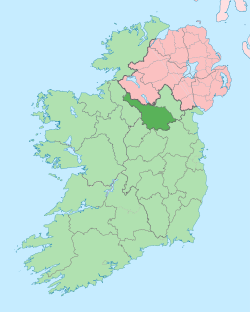 | |
| Villages |
| |
| Townlands | ||
| Landforms | ||
| ||
Lists of Marilyns | |
|---|---|