South Dakota Highway 11
| ||||
|---|---|---|---|---|
|
Route of SD 11 (in red) | ||||
| Route information | ||||
| Defined by SDCL §31-4-131 | ||||
| Maintained by SDDOT | ||||
| Length: | 81.707 mi[1] (131.495 km) | |||
| Existed: | 1929 – present | |||
| Southern segment | ||||
| Length: | 5.046 mi (8.121 km) | |||
| South end: |
| |||
| North end: |
| |||
| Northern segment | ||||
| Length: | 76.661 mi (123.374 km) | |||
| South end: |
| |||
| Major junctions: |
| |||
| North end: |
| |||
| Location | ||||
| Counties: | Union, Lincoln, Minnehaha, Moody | |||
| Highway system | ||||
| ||||

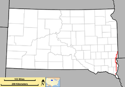
South Dakota Highway 11 (SD 11) is a state route in southeast South Dakota. It is split into two segments. The shorter of these segments begins at I-29 Bus. in Elk Point and runs north to an intersection with SD 50, and is approximately five miles (8.0 km) long. The longer segment begins at an intersection with SD 48 and runs northerly through Sioux Falls to the Minnesota state line north of Sherman where it continues east as Minnesota State Highway 269. This segment is about 77 miles (124 km) in length.
In total, the SD 11 designation spans just under 82 miles (132 km).
Route description
SD 11 is defined by South Dakota Codified Law §31-4-131.[2] According to this statute, the segment of the road between SD 48 and SD 50 is currently not a portion of the highway. The segment of the highway in Sioux Falls from 85th Street through the concurrency with SD 42, as well as the segment from the Madison Street intersection to the interchange with I-90, are included in the National Highway System,[3] a system of highways important to the nation's defense, economy, and mobility.[4]
Southern segment
The southern segment of SD 11 begins at the corner of I-29 Bus. and Franklin Street in Elk Point. The route turns west onto Rose Street. The highway then curves to the north, leaving the city of Elk Point and ending at an intersection with SD 50.[5]
Northern segment
The northern segment of SD 11 begins at the intersection of 479th Avenue and SD 48 and travels north through mainly rural portions of northern Union County. Continuing north, the highway passes through the small community of Alcester. Four miles north of Alcester, SD 11 intersects SD 46, a highway that runs along the Union-Lincoln county line. The route heads farther north for roughly fifteen miles through rural Lincoln County, running parallel to, and about eight miles east of Interstate 29. The highway turns west and begins a concurrency with US 18 west of Canton. The concurrency runs west for one mile before SD 11 branches north and US 18 continues west.[6]
Nine miles north of the concurrency with US 18, the highway intersects Lincoln County Highway 110. This road leads to Harrisburg and Tea, two southern suburbs of Sioux Falls. Three miles north of this intersection, the highway crosses 85th Street and enters Sioux Falls. Two miles north of 85th Street, the highway crosses 57th Street and enters Minnehaha County. SD 11 traverses both urban and rural portions of Sioux Falls on the eastern extremities of the city. Inside the city limits, the highway is known as Powder House Road. At its intersection with 10th Street SD 11 turns east and begins a concurrency with SD 42.
The highway travels east for roughly three miles, before SD 11 branches north for five miles and enters Brandon, the largest suburb of Sioux Falls. The highway is known as Splitrock Boulevard in Brandon and runs for about two miles in the city limits before sharing an interchange with Interstate 90. Just north of the interchange is the unincorporated community of Corson.[6]
After passing through Corson, SD 11 heads north for six miles, then heads east for three miles and intersects 485th Avenue, a short road that leads to Palisades State Park. Immediately north of this intersection, the highway enters Garretson. In northern Garretson, the route runs just west of Devil's Gulch. About nine miles north of Garretson the highway curves northeast for a mile, then east along the Minnehaha-Moody county line. The highway runs east for three miles before entering Minnesota just west of Jasper, Minnesota and becoming Minnesota State Highway 269.[6]
History
When designated in the 1929, South Dakota 11 began at U.S. Highway 16 near Brandon, and continued north via Sherman (but bypassing Garretson) to Minnesota; a second segment began at South Dakota Highway 34 near Flandreau, running north to U.S. Highway 14 west of Elkton. This northern segment became South Dakota Highway 13 around 1935. A rerouting in the early 1940s brought SD 11 through Garretson.
Around 1960, SD 11 was brought into the east side of Sioux Falls, then extended southward to U.S. Highway 18 west of Canton. Around 1970, the extension southward to Elk Point was in place.
Major intersections
| County | Location | mi[1] | km | Destinations | Notes | ||
|---|---|---|---|---|---|---|---|
| Union | Elk Point | 0.000 | 0.000 | ||||
| Richland | 5.046 | 8.121 | |||||
| Gap in route | |||||||
| Union | | 5.046 | 8.121 | ||||
| Union–Lincoln county line | | 21.099 | 33.956 | ||||
| Lincoln | | 36.115 | 58.121 | South end of US 18 concurrency | |||
| | 37.110 | 59.723 | North end of US 18 concurrency | ||||
| Minnehaha | Sioux Falls | 53.906 | 86.753 | South end of SD 42 concurrency | |||
| 54.002 | 86.908 | North end of SD 42 concurrency | |||||
| Brandon | 60.009 | 96.575 | Exit 406 on I-90 | ||||
| Minnehaha–Moody county line | | 81.707 | 131.495 | Continuation into Minnesota | |||
1.000 mi = 1.609 km; 1.000 km = 0.621 mi
| |||||||
References
- 1 2 "State Highway Log" (PDF). Mitchell region: South Dakota Department of Transportation. January 2011. pp. 100–104. Archived from the original on January 7, 2008. Retrieved December 21, 2011.
- ↑ "South Dakota Statute 31-4-131". Retrieved October 18, 2012.
- ↑ "NHS Map of Sioux Falls" (PDF).
- ↑ "The National Highway System". Retrieved October 18, 2012.
- ↑ Google (October 16, 2012). "South Dakota Highway 11 Southern Segment Overview" (Map). Google Maps. Google. Retrieved October 16, 2012.
- 1 2 3 Google (October 17, 2012). "South Dakota Highway 11 Northern Segment Overview" (Map). Google Maps. Google. Retrieved October 17, 2012.