Beresford, South Dakota
| Beresford, South Dakota | |
|---|---|
| City | |
 | |
 Location in Union County and the state of South Dakota | |
| Coordinates: 43°4′51″N 96°46′34″W / 43.08083°N 96.77611°WCoordinates: 43°4′51″N 96°46′34″W / 43.08083°N 96.77611°W | |
| Country | United States |
| State | South Dakota |
| Counties | Union, Lincoln |
| Incorporated | July 12, 1884[1] |
| Government | |
| • Mayor | Jim Fedderson |
| • City Council |
Councilmembers
|
| Area[2] | |
| • Total | 1.78 sq mi (4.61 km2) |
| • Land | 1.78 sq mi (4.61 km2) |
| • Water | 0 sq mi (0 km2) |
| Elevation | 1,499 ft (457 m) |
| Population (2010)[3] | |
| • Total | 2,005 |
| • Estimate (2015)[4] | 1,976 |
| • Density | 1,126.4/sq mi (434.9/km2) |
| Time zone | Central (CST) (UTC-6) |
| • Summer (DST) | CDT (UTC-5) |
| ZIP code | 57004 |
| Area code(s) | 605 |
| FIPS code | 46-04980 |
| GNIS feature ID | 1267667[5] |
| Website | www.beresfordsd.com |
Beresford is a city in Lincoln and Union counties in the State of South Dakota. The population was 2,005 as of the 2010 census. The southern two-thirds is part of the Sioux City, IA-NE-SD Metropolitan Statistical Area, while the northern one-third is part of the Sioux Falls Metropolitan Statistical Area. The Beresford Republic is the weekly newspaper.
History
Beresford was originally called Paris, and under the latter name was laid out in 1873.[6] The city was renamed after Lord Charles Beresford[7] and was formally incorporated on July 12, 1884.
Geography
Beresford is located at 43°4′51″N 96°46′34″W / 43.08083°N 96.77611°W (43.080859, -96.776148).[8]
According to the United States Census Bureau, the city has a total area of 1.78 square miles (4.61 km2), all land.[2]
Beresford is located on the border between Lincoln and Union counties; the border between the counties is located along Beresford's Cedar Street. Approximately two-thirds of Beresford's area (including its city hall building) is located in Union County.
Demographics
| Historical population | |||
|---|---|---|---|
| Census | Pop. | %± | |
| 1890 | 494 | — | |
| 1900 | 1,046 | 111.7% | |
| 1910 | 1,117 | 6.8% | |
| 1920 | 1,519 | 36.0% | |
| 1930 | 1,460 | −3.9% | |
| 1940 | 1,642 | 12.5% | |
| 1950 | 1,686 | 2.7% | |
| 1960 | 1,794 | 6.4% | |
| 1970 | 1,655 | −7.7% | |
| 1980 | 1,865 | 12.7% | |
| 1990 | 1,849 | −0.9% | |
| 2000 | 2,006 | 8.5% | |
| 2010 | 2,005 | 0.0% | |
| Est. 2015 | 1,976 | [9] | −1.4% |
| U.S. Decennial Census[10] 2015 Estimate[4] | |||
2010 census
As of the census[3] of 2010, there were 2,005 people, 861 households, and 561 families residing in the city. The population density was 1,126.4 inhabitants per square mile (434.9/km2). There were 959 housing units at an average density of 538.8 per square mile (208.0/km2). The racial makeup of the city was 98.5% White, 0.2% African American, 0.1% Native American, 0.2% Asian, 0.1% from other races, and 0.8% from two or more races. Hispanic or Latino of any race were 1.1% of the population.
There were 861 households of which 29.6% had children under the age of 18 living with them, 54.8% were married couples living together, 7.0% had a female householder with no husband present, 3.4% had a male householder with no wife present, and 34.8% were non-families. 31.2% of all households were made up of individuals and 15.7% had someone living alone who was 65 years of age or older. The average household size was 2.33 and the average family size was 2.92.
The median age in the city was 38.5 years. 25.4% of residents were under the age of 18; 6.3% were between the ages of 18 and 24; 26.2% were from 25 to 44; 22.9% were from 45 to 64; and 19.1% were 65 years of age or older. The gender makeup of the city was 49.4% male and 50.6% female.
2000 census
As of the census of 2000, there were 2,006 people, 852 households, and 535 families residing in the city. The population density was 1,130.1 people per square mile (435.1/km²). There were 919 housing units at an average density of 517.7 per square mile (199.3/km²). The racial makeup of the city was 98.90% White, 0.55% Native American, 0.30% Asian, 0.05% from other races, and 0.20% from two or more races. Hispanic or Latino of any race were 0.40% of the population.
There were 852 households out of which 29.6% had children under the age of 18 living with them, 52.5% were married couples living together, 7.2% had a female householder with no husband present, and 37.1% were non-families. 33.8% of all households were made up of individuals and 19.7% had someone living alone who was 65 years of age or older. The average household size was 2.29 and the average family size was 2.94.
In the city the population was spread out with 24.3% under the age of 18, 9.6% from 18 to 24, 21.6% from 25 to 44, 22.3% from 45 to 64, and 22.1% who were 65 years of age or older. The median age was 39 years. For every 100 females there were 90.0 males. For every 100 females age 18 and over, there were 87.2 males.
As of 2000 the median income for a household in the city was $35,331, and the median income for a family was $45,231. Males had a median income of $27,500 versus $19,057 for females. The per capita income for the city was $17,903. About 1.1% of families and 4.2% of the population were below the poverty line, including 0.8% of those under age 18 and 13.9% of those age 65 or over.
Climate
Beresford is located very near to the center of the North American continent, far removed from any major bodies of water. This lends the area a humid continental climate, with hot, humid summers, cold snowy winters, and wide temperature extremes. Summers can bring daytime temperatures that climb into the 90s Fahrenheit, and winter lows can be well below zero.
Education
Beresford High School is the only high school in the Beresford School District. The Beresford High School and Middle School are located on the South Campus of the Beresford School District, and the Beresford Elementary School is located at the North Campus, along with the Community Education Building, which houses the Beresford Pre-School Program.
Administrative Staff
- Brian Field, Superintendent
- Dustin Degen, 6-12 Principal
- Kevin Nelson, K-5 Principal
- Jared Olson, Business Manager
- Mike Busch, Athletic Director
Beresford High School recognizes the following sports: football, cross country, boys golf, girls golf, volleyball, wrestling, track, girls basketball, boys basketball, dance, and cheerleading. Beresford High School also recognizes the following non-athletic programs: marching band, concert band, drama, concert choir, All-State Chorus, All-State Band, Future Farmers of America, Family Career and Community Leaders of America, school newspaper, school yearbook, quiz bowl, Students Working Against Tobacco, National Honor Society, Meals on Wheels, and Student Government.
Library
The Beresford Library was originally conceived and nurtured by the Beresford Study Club. In 1923, a committee was appointed to come up with the necessary planning and arrangements. At first, the club members were the ones who contributed books to the library via a book shower, which resulted in forty volumes of reference works as well as fiction. Not long after this, the public was invited to donate books to the collection, and this effort produced another hundred books. The study club started up a fund for the library foundation, and through various fundraising efforts accrued $300 for the purchase of more books.[11] In 1924, both the size and popularity of the library were too much for the women of the study club to sponsor, so they appealed to the city attorney to see if the city would take over responsibility, and at the December meeting of the library board meeting that same year, it was officially announced that the city would take over the library.[11]
The original library occupied a small area on the second floor of the fire station. As of 1959, there were approximately 10,000 volumes classified with the Dewey Decimal System.[11] In 1963, with the help of the local Boy Scouts, the library moved to a new home in the former Post Office building. This was also the time when new forms of media were added to the collection, such as talking books, film strips, and movie projectors.[12] In 1972, the library was expanded further by refurbishing the basement, which would house the youth library. By 1983, the library collection consisted of approximately 20,000 books and much media.[12] The current library resides on 3rd Street, and was opened to the public in that venue in the fall of 1992.[13] The library currently holds nearly 30,000 items.
Notable people
- William J. Bulow - former South Dakota Governor and United States Senator
- Robert Casey - decorated soldier, war correspondent and reporter
- Don Fedderson - television executive producer and creator of programs including Family Affair, The Lawrence Welk Show, and My Three Sons
- Vince Lloyd - former baseball broadcaster (Chicago Cubs)
- Ernest Lundeen - former Minnesota senator
- Mike Busch (American football) - former NFL player, football coach at Beresford High School
Further reading
- Centennial Book Committee (eds.) (1983), Beresford 1884-1984, Beresford Republic and Lennox Independent.
- Beresford's 75th Diamond Jubilee: 1884-1959, (1959).
References
- ↑ "SD Towns" (PDF). South Dakota State Historical Society. Archived from the original (PDF) on 2010-02-10. Retrieved 2010-02-11.
- 1 2 "US Gazetteer files 2010". United States Census Bureau. Archived from the original on 2012-07-14. Retrieved 2012-06-21.
- 1 2 "American FactFinder". United States Census Bureau. Retrieved 2012-06-21.
- 1 2 "Population Estimates". United States Census Bureau. Retrieved June 7, 2016.
- ↑ "US Board on Geographic Names". United States Geological Survey. 2007-10-25. Retrieved 2008-01-31.
- ↑ Federal Writers' Project (1940). South Dakota place-names, v.1-3. University of South Dakota. p. 26.
- ↑ Chicago and North Western Railway Company (1908). A History of the Origin of the Place Names Connected with the Chicago & North Western and Chicago, St. Paul, Minneapolis & Omaha Railways. p. 43.
- ↑ "US Gazetteer files: 2010, 2000, and 1990". United States Census Bureau. 2011-02-12. Retrieved 2011-04-23.
- ↑ "Annual Estimates of the Resident Population for Incorporated Places: April 1, 2010 to July 1, 2015". Retrieved June 7, 2016.
- ↑ United States Census Bureau. "Census of Population and Housing". Archived from the original on May 11, 2015. Retrieved September 23, 2013.
- 1 2 3 Beresford's 75th Diamond Jubilee, p.24
- 1 2 Beresford 1884-1984, edited by the Centennial Book Committee, 1983, p. 157
- ↑ Beresford Republic, April 29, 1993
External links
- Beresford Municipal Telephone Company Website
- Beresford School District Website
- Beresford Library Website
- Beresford History from the Union County Historical Society website
- Beresford History from the Regional Histories website.
- City of Beresford Official Website
Municipalities and communities of Lincoln County, South Dakota, United States | ||
|---|---|---|
| Cities | 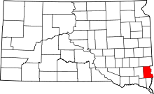 | |
| Towns | ||
| Townships |
| |
| CDP | ||
| Footnotes | ‡This populated place also has portions in an adjacent county or counties | |
Municipalities and communities of Union County, South Dakota, United States | ||
|---|---|---|
| Cities |  | |
| Townships | ||
| CDPs | ||
| Other unincorporated communities | ||
| Ghost town | ||
| Footnotes | ‡This populated place also has portions in an adjacent county or counties | |