Alcester, South Dakota
| Alcester, South Dakota | |
|---|---|
| City | |
| Motto: "Small Town Treasure" | |
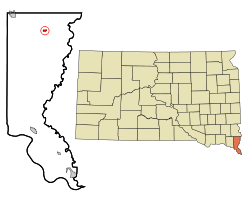 Location in Union County and the state of South Dakota | |
| Coordinates: 43°1′23″N 96°37′50″W / 43.02306°N 96.63056°WCoordinates: 43°1′23″N 96°37′50″W / 43.02306°N 96.63056°W | |
| Country | United States |
| State | South Dakota |
| County | Union |
| Incorporated | 1893[1] |
| Government | |
| • Mayor | Rick Johnson |
| Area[2] | |
| • Total | 0.33 sq mi (0.85 km2) |
| • Land | 0.33 sq mi (0.85 km2) |
| • Water | 0 sq mi (0 km2) |
| Elevation | 1,375 ft (419 m) |
| Population (2010)[3] | |
| • Total | 807 |
| • Estimate (2015)[4] | 761 |
| • Density | 2,445.5/sq mi (944.2/km2) |
| Time zone | Central (CST) (UTC-6) |
| • Summer (DST) | CDT (UTC-5) |
| ZIP code | 57001 |
| Area code(s) | 605 |
| FIPS code | 46-00700 |
| GNIS feature ID | 1253607[5] |
| Website | www.alcestersd.org |
Alcester is a city in Union County, South Dakota, United States. It is part of the Sioux City, IA–NE–SD Metropolitan Statistical Area. The population was 807 at the 2010 census.
History
Alcester was platted in 1879; early variant names were Linia and Irene.[6] The present name honors Colonel Alcester of the British army.[7] The weekly Alcester Union newspaper began publishing in 1888.[8]
Geography
According to the United States Census Bureau, the city has a total area of 0.33 square miles (0.85 km2), all land.[2]
Demographics
| Historical population | |||
|---|---|---|---|
| Census | Pop. | %± | |
| 1900 | 381 | — | |
| 1910 | 409 | 7.3% | |
| 1920 | 492 | 20.3% | |
| 1930 | 460 | −6.5% | |
| 1940 | 581 | 26.3% | |
| 1950 | 585 | 0.7% | |
| 1960 | 479 | −18.1% | |
| 1970 | 627 | 30.9% | |
| 1980 | 885 | 41.1% | |
| 1990 | 843 | −4.7% | |
| 2000 | 880 | 4.4% | |
| 2010 | 807 | −8.3% | |
| Est. 2015 | 761 | [9] | −5.7% |
| U.S. Decennial Census[10] 2015 Estimate[4] | |||
2010 census
As of the census[3] of 2010, there were 807 people, 352 households, and 218 families residing in the city. The population density was 2,445.5 inhabitants per square mile (944.2/km2). There were 408 housing units at an average density of 1,236.4 per square mile (477.4/km2). The racial makeup of the city was 97.4% White, 0.1% African American, 0.2% Native American, 0.7% Asian, 0.2% from other races, and 1.2% from two or more races. Hispanic or Latino of any race were 1.5% of the population.
There were 352 households of which 25.6% had children under the age of 18 living with them, 49.4% were married couples living together, 9.9% had a female householder with no husband present, 2.6% had a male householder with no wife present, and 38.1% were non-families. 33.0% of all households were made up of individuals and 18.8% had someone living alone who was 65 years of age or older. The average household size was 2.16 and the average family size was 2.72.
The median age in the city was 48.8 years. 21.8% of residents were under the age of 18; 3.2% were between the ages of 18 and 24; 20.1% were from 25 to 44; 27.8% were from 45 to 64; and 27.1% were 65 years of age or older. The gender makeup of the city was 47.8% male and 52.2% female.
2000 census
As of the census of 2000, there were 880 people, 388 households, and 233 families residing in the city. The population density was 2,590.8 people per square mile (999.3/km²). There were 430 housing units at an average density of 1,266.0 per square mile (488.3/km²). The racial makeup of the city was 98.41% White, 0.23% Native American, 0.91% Asian, and 0.45% from two or more races.
There were 388 households out of which 25.0% had children under the age of 18 living with them, 53.4% were married couples living together, 5.7% had a female householder with no husband present, and 39.7% were non-families. 36.9% of all households were made up of individuals and 24.7% had someone living alone who was 65 years of age or older. The average household size was 2.10 and the average family size was 2.72.
In the city the population was spread out with 18.9% under the age of 18, 5.8% from 18 to 24, 19.9% from 25 to 44, 22.2% from 45 to 64, and 33.3% who were 65 years of age or older. The median age was 48 years. For every 100 females there were 74.6 males. For every 100 females age 18 and over, there were 71.6 males.
The median income for a household in the city was $29,432, and the median income for a family was $44,286. Males had a median income of $28,047 versus $21,167 for females. The per capita income for the city was $16,593. About 6.5% of families and 7.9% of the population were below the poverty line, including 3.8% of those under the age of 18 and 16.0% of those 65 and older.
Education
Alcester-Hudson High School is the only high school in the Alcester-Hudson School District.
References
- ↑ "SD Towns" (PDF). South Dakota State Historical Society. Archived (PDF) from the original on 10 February 2010. Retrieved 2010-02-10.
- 1 2 "US Gazetteer files 2010". United States Census Bureau. Archived from the original on 2012-01-24. Retrieved 2012-06-21.
- 1 2 "American FactFinder". United States Census Bureau. Retrieved 2012-06-21.
- 1 2 "Population Estimates". United States Census Bureau. Retrieved June 12, 2016.
- ↑ "US Board on Geographic Names". United States Geological Survey. 2007-10-25. Retrieved 2008-01-31.
- ↑ Federal Writers' Project (1940). South Dakota place-names, v.1-3. University of South Dakota. p. 21.
- ↑ "Profile for Alcester, South Dakota". ePodunk. Retrieved 2010-06-19.
- ↑ Hunhoff, Bernie (2013). "The Makings of a Town". South Dakota Magazine (November / December 2013). Retrieved March 2, 2016.
- ↑ "Annual Estimates of the Resident Population for Incorporated Places: April 1, 2010 to July 1, 2015". Retrieved July 2, 2016.
- ↑ United States Census Bureau. "Census of Population and Housing". Archived from the original on May 11, 2015. Retrieved September 23, 2013.
External links
Municipalities and communities of Union County, South Dakota, United States | ||
|---|---|---|
| Cities |  | |
| Townships | ||
| CDPs | ||
| Other unincorporated communities | ||
| Ghost town | ||
| Footnotes | ‡This populated place also has portions in an adjacent county or counties | |