Springfield Township, Delaware County, Pennsylvania
| Springfield Township, Pennsylvania | |
| Township | |
| Country | United States |
|---|---|
| State | Pennsylvania |
| County | Delaware |
| Elevation | 243 ft (74.1 m) |
| Coordinates | 39°56′00″N 75°19′59″W / 39.93333°N 75.33306°WCoordinates: 39°56′00″N 75°19′59″W / 39.93333°N 75.33306°W |
| Area | 6.3 sq mi (16.3 km2) |
| - land | 6.3 sq mi (16 km2) |
| - water | 0.02 sq mi (0 km2), 0.32% |
| Population | 24,211 (2010) |
| Density | 3,830.5/sq mi (1,479.0/km2) |
| Founded | 1686 |
| Timezone | EST (UTC-5) |
| - summer (DST) | EDT (UTC-4) |
| ZIP code | 19064 |
| Area code | 610 and 484 |
| FIPS code | 42-045-73032 |
| GNIS feature ID | 1216391 |
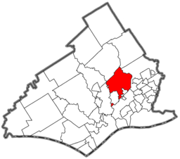 Location of Springfield Township in Delaware County | |
 Location of Springfield Township in Pennsylvania | |
 Location of Pennsylvania in the United States | |
| Website: www | |
Springfield Township, or simply Springfield, is a township in Delaware County in the U.S. state of Pennsylvania. The population was 24,211 at the 2010 census.[1] Springfield is a suburb of Philadelphia, located about 10 miles (16 km) west of the city.
Geography
Springfield is located in eastern Delaware County at 39°55′37″N 75°20′7″W / 39.92694°N 75.33528°W (39.926961, -75.335231).[2] According to the United States Census Bureau, the township has a total area of 6.34 square miles (16.42 km2), of which 6.32 square miles (16.37 km2) is land and 0.02 square miles (0.05 km2), or 0.28%, is water.[1] The northeastern border of the township is formed by Darby Creek, and the western border is formed by Crum Creek, both of which flow south to the Delaware River.
Adjacent municipalities
- Haverford Township, Delaware County - north
- Upper Darby Township, Delaware County - east
- Ridley Township, Delaware County - south
- Morton Borough, Delaware County - south
- Swarthmore Borough, Delaware County - southwest. (A small exclave of Springfield Township is located south of Swarthmore Boro (see map to right)).
- Nether Providence Township, Delaware County - southwest
- Marple Township, Delaware County - northwest
Demographics
| Historical population | |||
|---|---|---|---|
| Census | Pop. | %± | |
| 1930 | 4,589 | — | |
| 1940 | 5,488 | 19.6% | |
| 1950 | 10,917 | 98.9% | |
| 1960 | 26,733 | 144.9% | |
| 1970 | 29,006 | 8.5% | |
| 1980 | 25,326 | −12.7% | |
| 1990 | 24,160 | −4.6% | |
| 2000 | 23,677 | −2.0% | |
| 2010 | 24,211 | 2.3% | |
As of the census[3] of 2000, there were 23,677 people, 8,618 households, and 6,790 families residing in the township. The population density was 3,723.0 people per square mile (1,437.4/km²). There were 8,800 housing units at an average density of 1,383.7/sq mi (534.2/km²). The racial makeup of the township was 94.6% White, 0.5% African American, 0.05% Native American, 4.2% Asian, 0.01% Pacific Islander, 0.12% from other races, and 0.54% from two or more races. Hispanic or Latino of any race were 1.65% of the population.
There were 8,618 households, out of which 32.7% had children under the age of 18 living with them, 67.3% were married couples living together, 8.6% had a female householder with no husband present, and 21.2% were non-families. 19.3% of all households were made up of individuals, and 11.9% had someone living alone who was 65 years of age or older. The average household size was 2.73 and the average family size was 3.14.
In the township the population was spread out, with 24.0% under the age of 18, 6.2% from 18 to 24, 25.0% from 25 to 44, 24.5% from 45 to 64, and 20.3% who were 65 years of age or older. The median age was 42 years. For every 100 females there were 91.8 males. For every 100 females age 18 and over, there were 88.4 males.
The median income for a household in the township was $89,019, and the median income for a family was $103,424.[4] Males had a median income of $64,830 versus $50,651 for females.[4] The per capita income for the township was $35,231. About 1.7% of families and 3.4% of the population were below the poverty line, including 5.3% of those under age 18 and 6.7% of those age 65 or over.
Education

Pupils in Springfield attend schools in the Springfield School District. This is not to be confused with Springfield Township School District, which is located in Springfield Township, Montgomery County.
The public school system comprises three elementary schools: Springfield Literacy Center, Scenic Hills and Sabold; one middle school: E. T. Richardson Middle School; and one high school: Springfield High School. The Springfield Literacy Center contains all students of Kindergarten and first grade; Scenic Hills (or just "Scenic") and Sabold contain various students grades 2 through 5 (depending on which one is closer to you); E. T. Richardson (or ETR) contains grades 6, 7, and 8; and Springfield High School contains grades 9 through 12. Springfield High School currently has 1,200 students enrolled.
There is one private Catholic high school: Cardinal O'Hara High School. There are two private Catholic grade schools: Holy Cross and St. Francis of Assisi. St. Kevin School operated from 1967- 2011.
History
First settled by Quakers who arrived in Pennsylvania with William Penn, Springfield was first recognized as a governmental entity in 1686. Many of the streets in Springfield are named after former prominent citizens, including Powell, Kennerly, Lownes, Thomas, Beatty, Lewis, Foulke, Evans, Powell, Pancoast, Worrell, and Edge. After its founding, Springfield was primarily a farming town.
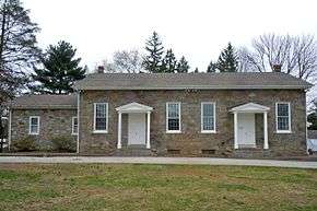
On December 9, 1687, the settlers began laying the road to Amosland as it was then called. This road is now known as Springfield Road. In 1701 construction began on the Baltimore Pike; the road was formed of sturdy oak planks, some of which still exist under the current Baltimore Pike. 1701 also marked the year that construction began on the first Quaker meeting house. The meeting house burned in 1737 and was rebuilt. The current meeting house that stands in its spot was constructed in 1851.
By the date of the signing of the Declaration of Independence in 1776 it is estimated from tax records that about 300 people resided in Springfield.
By the 19th century Springfield had become more industrialized. Taking advantage of its many creeks, the inhabitants erected many mills. Well-known mill owners included William Fell, Samuel Pancoast, William Beatty, Samuel Levis, Moses Hey, and Emanuel Hey.
At the beginning of the 20th century Springfield's Baltimore Pike had become one of the busiest commercial areas outside of Philadelphia. The long, straight stretch of Baltimore Pike in the township was referred to "The Golden Mile", commonly known for its many automobile dealerships. The Golden Mile is a unique corridor that is essentially a compact commercial strip that cuts directly through bedroom communities on both sides. Residents are currently attempting to undo the emblematic effects of urban sprawl along the mile through the implementation of green initiatives, responsible traffic planning, and zoning improvements.
In the past century, all of Springfield's farmland was slowly bought up by developers who turned Springfield into the town it is today, that is, largely comprising developments of standard suburban single-family homes. One of the largest single developments was the Stoney Creek development. Construction began in 1949 and was completed in only five years. The huge development stretched from West Avenue to Providence Road and ran all the way up to Baltimore Pike. Over 75 homes were constructed in the development. Unlike most housing developments of their time, no two houses in Stoney Creek were built exactly the same. While all resemble each other with their stone fronts and common size, slight variations such as porches and window placement differed on each house, making each one slightly different.
Though all of the farmland of Springfield's past is gone, many of the woods and fields of the past still remain standing today in some of the many parks located throughout the community.
Currently, the bulk of Springfield's history lies recorded in the archives of the Heritage Society of Springfield, and the Springfield Township Public Library (a member of the Delaware County Library System).
Economy
The township is home to Springfield Mall, a 590,000-square-foot (55,000 m2), two-level shopping mall. One of the first of several suburban locations of Strawbridge & Clothier was located in Springfield. The old Strawbridge & Clothier has since been reconstructed into a Target.
People
- Bill Carpenter, West Point "Lonesome End", U.S. Army lieutenant general, recipient of Distinguished Service Cross
- Pat Croce entrepreneur, sports team executive and owner [5]
- Joey DeFrancesco, jazz organist
- Robert W. Edgar, U.S. Congressman
- Robert Hazard, rock musician
- Tom Keifer, rock musician in the band Cinderella
- Al Martino, singer, film actor
- Geoff Petrie, NBA Rookie of the Year, 1971
- Skip Roderick, former pro soccer player, current men's soccer coach at Elizabethtown College
- Mike Scioscia, LA Angels manager, MLB All-Star catcher
- Joe Sestak, Three Star Admiral and U.S. Congressman
- Benjamin West, painter
- Lawrence G. Williams, U.S. Congressman
Notable Buildings
- Central School (demolished)
- First Presbyterian Church
- Holy Cross Church
- The Old School House
- Springfield High School
- Springfield Mall
- The Springfield Literacy Center (2011)
- The Springfield Friends Meeting House
- St. Francis of Assisi Church
Notable Parks
There are 24 parks located in Springfield Township, some of the more notable parks are listed below.[7]
- Veterans Memorial Park
- Williams Park (former Powell Road Park)
- Jane Lownes Park
- Indian Rock Park
- Meadowgreen Park
- Halderman Field
- Netherwood Park
- Walsh Park
- Rolling Green Park
- Crowell Park
References
- 1 2 "Geographic Identifiers: 2010 Demographic Profile Data (G001): Springfield township, Delaware County, Pennsylvania". U.S. Census Bureau, American Factfinder. Retrieved December 30, 2015.
- ↑ "US Gazetteer files: 2010, 2000, and 1990". United States Census Bureau. 2011-02-12. Retrieved 2011-04-23.
- ↑ "American FactFinder". United States Census Bureau. Retrieved 2008-01-31.
- 1 2 http://factfinder2.census.gov/faces/tableservices/jsf/pages/productview.xhtml?pid=ACS_11_5YR_DP03
- ↑ Croce, Pat; Lyon, Bill (2000). I Feel Great and You Will Too!:An Inspiring Journey of Success with Practical Tips on How to Score Big in Life. Running Press.
- ↑ Morfe, Don (March 10, 2015). "Springfield Friends Meeting". www.hmdb.org. Retrieved Feb 26, 2016.
- ↑ "www.springfielddelco.org". Retrieved February 18, 2016.
External links
| Wikimedia Commons has media related to Springfield Township, Delaware County, Pennsylvania. |
Municipalities and communities of Delaware County, Pennsylvania, United States | ||
|---|---|---|
| City | 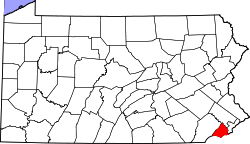 | |
| Boroughs | ||
| Townships | ||
| CDPs | ||
| Unincorporated communities |
| |
| Footnotes | ‡This populated place also has portions in an adjacent county or counties | |