St Cyrus
| St Cyrus | |
| Scottish Gaelic: Eaglais Chiric | |
| Scots: Saunt Ceerus | |
.jpg) St Cyrus church |
|
 St Cyrus |
|
| OS grid reference | NO7171 |
|---|---|
| Council area | Aberdeenshire |
| Lieutenancy area | Kincardineshire |
| Country | Scotland |
| Sovereign state | United Kingdom |
| Post town | Montrose |
| Postcode district | DD10 |
| Dialling code | 01674 |
| Police | Scottish |
| Fire | Scottish |
| Ambulance | Scottish |
| EU Parliament | Scotland |
| UK Parliament | West Aberdeenshire and Kincardine |
| Scottish Parliament | Angus North and Mearns |
Coordinates: 56°46′30″N 2°24′57″W / 56.775°N 2.4158°W
St Cyrus or Saint Cyrus (Scots: Saunt Ceerus),[1] formerly Ecclesgreig (from Scottish Gaelic: Eaglais Chiric) is a village in the far south of Aberdeenshire, Scotland.
General information
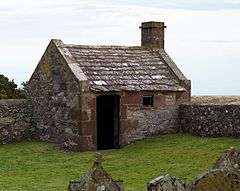
St Cyrus National Nature Reserve is a national nature reserve situated between the village and the North Sea. The cliffs and dunes provide a nationally important habitat for flowering plants and insects.[2] Traditional salmon fishing with nets is still conducted from St Cyrus beach. Two ice houses that used to provide ice for packing salmon before transporting to market can still be seen. One is to the north end of the beach on the donkey track just below the Woodston Fishing Station, the other is further south next to Kirkside [this is now a private dwelling], not far from the Nature Reserve Visitor's Centre.
Area prehistory
There are known prehistorical archaeological sites in the general coastal area of St Cyrus. Examples of these features include Gourdon Hill[3] to the north and the Stone of Morphie,[4] both situated slightly to the west of the A92 road alignment.
History
The remains of the Kaim of Mathers is located on rock pinnacles on the northernmost part of the beach. Built by the Berkeley (or Barclay) family, it was used as a refuge by David de Berkely from the vengeance of the king when, around 1420, he was part of a group who murdered the local sheriff, John Melville of Glenbervie.[5][6]
St Cyrus was on the Montrose to Inverbervie branch line of the North British Railway. This line was closed as part of the Beeching cuts in the 1960s. Evidence for the line can still be seen in the viaduct over the North Esk river to the south of St Cyrus and the remains of some railway embankments and road bridges to the north.
A Home Chain Low radar station was once situated on the cliffs immediately to the south of the village. A blockhouse can still be seen at its location.
Notable residents
Geography
 |
Laurencekirk | Johnshaven | | |
| Marykirk | |
North Sea | ||
| ||||
| | ||||
| Montrose | North Sea |
Services
St Cyrus has a primary school with a Nursery Class and P1 to P7 classes.
An active Scout Group, with a Beaver Colony (ages 6–8), a Cub Pack (ages 8–10½) and a Scout Troop (ages 10½-14). Beavers and Cubs meet on a Monday night and Scouts meet on a Sunday afternoon at the Scout Hall, off of Beach Road.
St Cyrus has its own telephone exchange (code ESSTC). The exchange is fully enabled for BT ADSL, both fixed speed and ADSL Max flavours.
St Cyrus has a convenience store located on the main road, which also serves as the Post Office. Opposite the store there is a public phone box. There is a public convenience on the junction of the A92 and Ecclesgreig Road at the north of the village. There is a garage at the south end of the village which, until 2013, had a petrol station.
St Cyrus has a public hall located not far from the store on the A92. It was used for meetings of the local community council[7] until it disbanded in 2015, and a range of other activities. There is a sports pavilion at the local park, with an all-weather pitch and bowling green.
St Cyrus has a coffee shop (The Old Bakery) which has a gift shop within and also a local hotel (The Village Inn) which boasts The Great Scot bar. Both are situated on the main A92 road.
Situated approximately 1 mile North of St Cyrus, there is a residential caravan park which houses caravans for hire and permanent residents.
The Mearns Leader is the local weekly newspaper and The Courier is the regional newspaper, which is supplemented by a local community radio station, Mearns FM, that broadcasts from nearby Stonehaven.[8] The station is not-for-profit, and is volunteer run under a Community Radio Licence.[9] The Facebook page 'What's on St Cyrus' is the local social media page.
A defibrillator is located on Ecclesgreig Road.
Transport
St Cyrus is on the A92 road that runs from Fife to Stonehaven where it joins the A90 and continues to Aberdeen and beyond.
St Cyrus is on National Cycle Route 1 - Shetland to Dover.
The nearest railway stations are at Montrose, 5 miles (8.0 km) away, Laurencekirk, 7 miles (11 km) away and Stonehaven, 18 miles (29 km) away.
Buses (Nos 107, 113, 117 & X7) run between Montrose, St Cyrus and other coastal settlements up to Stonehaven and onward to Aberdeen.[10]
The nearest airport is at Aberdeen approximately 40 miles (64 km) to the north.
Demography
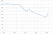
| Year | Population |
|---|---|
| 2011 | 1100[11] |
| 2006 | 1085[12] |
| 1991 | 851[13] |
| 1931 | 1173[14] |
| 1921 | 1306[15] |
| 1911 | 1222[16] |
| 1901 | 1228[17] |
| 1891 | 1327[18] |
| 1881 | 1487[19] |
| 1871 | 1585[20] |
| 1851 | 1579[21] |
| 1841 | 1164[22] |
| 1821 | 1641[23] |
| 1801 | 1622[24] |
| 1755 | 1271[25] |
Gallery
 St Cyrus Church
 The visitor centre at the Saint Cyrus National Nature Reserve
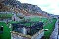 St Cyrus ancient kirkyard
 St Cyrus Beach
References
- ↑ The Online Scots Dictionary
- ↑ "Scottish Natural Heritage". Retrieved 2007-07-01.
- ↑ RCAHMS archaeological database: Gourdon
- ↑ C.Michael Hogan, Stone of Morphie, 2007, The Megalithic Portal, ed. A. Burnham
- ↑ Electric Scotland - Barclays
- ↑ Geograph - Kaim of Mathers
- ↑ "Aberdeenshire Community Councils".
- ↑ "Mearns FM".
- ↑ Mearns FM launch Press Release
- ↑ "Local Bus Timetables".
- ↑ "Aberdeenshire Council Small Area Population Estimates".
- ↑ "Aberdeenshire Council Small Area Population Estimates".
- ↑ "General Records Office for Scotland - 1991 Census - Index of Populated Areas in Scotland" (PDF).
- ↑ "Online Historical Population Reports - Preliminary report, Scotland, 1931 - Shire of Kincardine".
- ↑ "Online Historical Population Reports - Census of Scotland, Table 19, 1921 - Shire of Kincardine".
- ↑ "Online Historical Population Reports - Census of Scotland, Table VII, 1911 - Shire of Kincardine".
- ↑ "Online Historical Population Reports - Population, Scotland, Vol. I, 1901 - Shire of Kincardine".
- ↑ "Online Historical Population Reports - Population report, Scotland, Vol. I, 1891 - Shire of Kincardine".
- ↑ "Online Historical Population Reports - Population report, Scotland, Vol. I, 1881 - Shire of Kincardine".
- ↑ "Online Historical Population Reports -1871 Education Statistics - Shire of Kincardine".
- ↑ "Online Historical Population Reports -1851 Census - Shire of Kincardine".
- ↑ "Online Historical Population Reports -1841 Census - Shire of Kincardine".
- ↑ "Online Historical Population Reports -1821 Census - Shire of Kincardine".
- ↑ "Online Historical Population Reports -1801 Census - Shire of Kincardine".
- ↑ "Ordnance Gazetteer of Scotland - St Cyrus".
External links
| Wikimedia Commons has media related to St Cyrus. |
- Mearns Leader
- Overview of St Cyrus
- St Cyrus Newsletter
- St Cyrus School
- Sustrans
- YouTube video of the church and a 'Sandstorm'
Settlements and places of interest in Kincardine and Mearns, Aberdeenshire | ||
|---|---|---|
| Primary settlements |  | |
| Other settlements | ||
| Places of interest | ||
Areas and primary settlements in Aberdeenshire (see also: Aberdeen City) | ||
|---|---|---|
| in Banff and Buchan |  | |
| in Buchan | ||
| in Formartine | ||
| in Garioch | ||
| in Kincardine and Mearns | ||
| in Marr | ||