Ohio State Route 163
| ||||
|---|---|---|---|---|
 | ||||
| Route information | ||||
| Maintained by ODOT | ||||
| Length: | 46.24 mi[1][2] (74.42 km) | |||
| Existed: | 1923[3][4] – present | |||
| Major junctions | ||||
| West end: |
| |||
| East end: | Hartshorn Road near Marblehead | |||
| Location | ||||
| Counties: | Wood, Ottawa | |||
| Highway system | ||||
| ||||

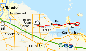
State Route 163 (SR 163) is a 46.24-mile (74.42 km) long east–west state highway in the northwestern portion of the U.S. state of Ohio. The western terminus of SR 163 is at a T-intersection with the duplex of U.S. Route 20 (US 20) and US 23 approximately 6 miles (9.7 km) southeast of the city limits of Perrysburg. Its eastern terminus is at its intersection with Hartshorn Road nearly 2 miles (3.2 km) west of the village limits of Marblehead, on the peninsula formed by Lake Erie and Sandusky Bay.
Route description
The path of SR 163 takes it through the northeastern portion of Wood County and the entire width of Ottawa County. No segment of this state route is included within the National Highway System.[5]
History
The SR 163 designation was applied in 1923. Originally, the highway ran along its present routing from its intersection with SR 51, at the time a part of SR 2 and later designated as the now-defunct SR 102, on the outskirts of Genoa, and its eastern terminus near Marblehead.[3][4] SR 163 was extended west into Wood County along a previously un-numbered road from Genoa to its present western terminus at US 20 southeast of Perrysburg.[6][7]
Major intersections
| County | Location | mi[1][2] | km | Destinations | Notes |
|---|---|---|---|---|---|
| Wood | Troy Township | 0.00 | 0.00 | Western terminus at T-intersection | |
| Troy–Lake township line | 2.29 | 3.69 | |||
| Ottawa | Clay Township | 8.90 | 14.32 | Signalized intersection | |
| Harris–Benton township line | 14.83 | 23.87 | |||
| Oak Harbor | 18.66 | 30.03 | Western end of SR 105 concurrency | ||
| 19.10 | 30.74 | Eastern end of SR 105 concurrency; eastern terminus of SR 105 | |||
| Erie Township | 25.69 | 41.34 | Southern terminus of SR 358 | ||
| 26.73 | 43.02 | Exit 115 (SR 2); access to eastbound SR 2 and from westbound SR 2 only | |||
| Port Clinton | 31.92 | 51.37 | Exit 121 (SR 2) | ||
| Danbury Township | 35.58 | 57.26 | |||
| 36.19 | 58.24 | Western end of SR 269 concurrency | |||
| 36.62 | 58.93 | Eastern end of SR 269 concurrency | |||
| 46.28 | 74.48 | Hartshorn Road | |||
1.000 mi = 1.609 km; 1.000 km = 0.621 mi
| |||||
References
- 1 2 Ohio Department of Transportation. "Technical Services Straight Line Diagrams: SR 163, Wood County" (PDF). Retrieved 2011-06-18.
- 1 2 Ohio Department of Transportation. "Technical Services Straight Line Diagrams: SR 163, Ottawa County" (PDF). Retrieved 2011-06-18.
- 1 2 Map of Ohio State Highways (MrSID) (Map). Cartography by ODHPW. Ohio Department of Highways and Public Works. April 1922. Retrieved 2011-08-26.
- 1 2 Map of Ohio Showing State Routes (MrSID) (Map). Cartography by ODHPW. Ohio Department of Highways and Public Works. July 1923. Retrieved 2011-08-26.
- ↑ National Highway System: Ohio (PDF) (Map). Federal Highway Administration. December 2003. Retrieved 2011-06-20.
- ↑ Map of Ohio Showing State Highway System (MrSID) (Map). Cartography by ODOH. Ohio Department of Highways. 1934. Retrieved 2011-08-26.
- ↑ Official Ohio Highway Map (MrSID) (Map). Cartography by ODOH. Ohio Department of Highways. 1935. Retrieved 2011-08-26.