Stetsonville, Wisconsin
| Stetsonville, Wisconsin | |
|---|---|
| Village | |
|
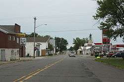
Looking south at downtown Stetsonville on WIS13 | |
 Location of Stetsonville, Wisconsin | |
| Coordinates: 45°4′35″N 90°18′50″W / 45.07639°N 90.31389°WCoordinates: 45°4′35″N 90°18′50″W / 45.07639°N 90.31389°W | |
| Country | United States |
| State | Wisconsin |
| County | Taylor |
| Area[1] | |
| • Total | 0.37 sq mi (0.96 km2) |
| • Land | 0.37 sq mi (0.96 km2) |
| • Water | 0 sq mi (0 km2) |
| Elevation[2] | 1,453 ft (443 m) |
| Population (2010)[3] | |
| • Total | 541 |
| • Estimate (2012[4]) | 533 |
| • Density | 1,462.2/sq mi (564.6/km2) |
| Time zone | Central (CST) (UTC-6) |
| • Summer (DST) | CDT (UTC-5) |
| Area code(s) | 715 & 534 |
| FIPS code | 55-77100[5] |
| GNIS feature ID | 1574869[2] |
Stetsonville is a village in Taylor County, Wisconsin, United States. The population was 541 at the 2010 census.
Geography
Stetsonville is located at 45°4′35″N 90°18′50″W / 45.07639°N 90.31389°W (45.076413, -90.313952).[6]
According to the United States Census Bureau, the village has a total area of 0.37 square miles (0.96 km2), all of it land.[1]
History
Stetsonville began when the Wisconsin Central Railway built its line through the area in 1872, heading north for Ashland. The stop was initially called "63." In 1875 Isiah Stetson built the first sawmill in town. The town was later named after him.[7]
The people of Stetsonville drew water from private wells until the 1980s, when petroleum contamination began to appear in some of them. A complete cleanup of the source was impossible, so in 2010 the village established a municipal water system, with help from the DNR, the USDA, the American Recovery and Reinvestment Act, and other sources.[8]
Demographics
| Historical population | |||
|---|---|---|---|
| Census | Pop. | %± | |
| 1950 | 334 | — | |
| 1960 | 319 | −4.5% | |
| 1970 | 305 | −4.4% | |
| 1980 | 487 | 59.7% | |
| 1990 | 511 | 4.9% | |
| 2000 | 563 | 10.2% | |
| 2010 | 541 | −3.9% | |
| Est. 2015 | 526 | [9] | −2.8% |
2010 census
As of the census[3] of 2010, there were 541 people, 242 households, and 156 families residing in the village. The population density was 1,462.2 inhabitants per square mile (564.6/km2). There were 263 housing units at an average density of 710.8 per square mile (274.4/km2). The racial makeup of the village was 98.5% White, 0.7% African American, 0.2% Asian, and 0.6% from two or more races. Hispanic or Latino of any race were 1.1% of the population.
There were 242 households of which 30.6% had children under the age of 18 living with them, 47.5% were married couples living together, 11.6% had a female householder with no husband present, 5.4% had a male householder with no wife present, and 35.5% were non-families. 31.8% of all households were made up of individuals and 14.8% had someone living alone who was 65 years of age or older. The average household size was 2.24 and the average family size was 2.76.
The median age in the village was 40 years. 23.7% of residents were under the age of 18; 8.3% were between the ages of 18 and 24; 27.2% were from 25 to 44; 23.8% were from 45 to 64; and 17% were 65 years of age or older. The gender makeup of the village was 49.0% male and 51.0% female.
2000 census
As of the census[5] of 2000, there were 563 people, 230 households, and 158 families residing in the village. The population density was 1,533.0 people per square mile (587.5/km²). There were 241 housing units at an average density of 656.2 per square mile (251.5/km²). The racial makeup of the village was 98.76% White, 0.18% Asian, 0.18% from other races, and 0.89% from two or more races. Hispanic or Latino of any race were 0.71% of the population.
There were 230 households out of which 35.2% had children under the age of 18 living with them, 57.8% were married couples living together, 7.8% had a female householder with no husband present, and 31.3% were non-families. 29.1% of all households were made up of individuals and 14.3% had someone living alone who was 65 years of age or older. The average household size was 2.45 and the average family size was 3.04.
In the village the population was spread out with 28.2% under the age of 18, 7.3% from 18 to 24, 29.7% from 25 to 44, 19.0% from 45 to 64, and 15.8% who were 65 years of age or older. The median age was 35 years. For every 100 females there were 89.6 males. For every 100 females age 18 and over, there were 87.9 males.
The median income for a household in the village was $32,045, and the median income for a family was $40,938. Males had a median income of $31,563 versus $23,875 for females. The per capita income for the village was $15,531. About 3.2% of families and 4.4% of the population were below the poverty line, including 5.8% of those under age 18 and 9.9% of those age 65 or over.
References
- 1 2 "US Gazetteer files 2010". United States Census Bureau. Retrieved 2012-11-18.
- 1 2 "US Board on Geographic Names". United States Geological Survey. 2007-10-25. Retrieved 2008-01-31.
- 1 2 "American FactFinder". United States Census Bureau. Retrieved 2012-11-18.
- ↑ "Population Estimates". United States Census Bureau. Retrieved 2013-06-24.
- 1 2 "American FactFinder". United States Census Bureau. Retrieved 2008-01-31.
- ↑ "US Gazetteer files: 2010, 2000, and 1990". United States Census Bureau. 2011-02-12. Retrieved 2011-04-23.
- ↑ Latton, Arthur J. (1947). Reminiscences and Anecdotes of Early Taylor County. La Crosse, Wisconsin: Brookhaven Press. pp. 191–193.
- ↑ Ballas, Eric (April 2012). "Stetsonville's thirst for success - Building a public water supply". Wisconsin Natural Resources. Retrieved 2012-04-10.
- ↑ "Annual Estimates of the Resident Population for Incorporated Places: April 1, 2010 to July 1, 2015". Retrieved July 2, 2016.
- ↑ "Census of Population and Housing". Census.gov. Retrieved June 4, 2015.
Municipalities and communities of Taylor County, Wisconsin, United States | ||
|---|---|---|
| City |  | |
| Villages | ||
| Towns | ||
| CDPs | ||
| Unincorporated communities | ||
| Footnotes | ‡This populated place also has portions in an adjacent county or counties | |