Stone Harbor, New Jersey
| Stone Harbor, New Jersey | |
|---|---|
| Borough | |
| Borough of Stone Harbor | |
|
| |
 Stone Harbor Borough highlighted in Cape May County. Inset map: Cape May County highlighted in the State of New Jersey. | |
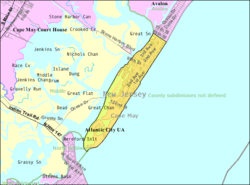 Census Bureau map of Stone Harbor, New Jersey | |
| Coordinates: 39°02′30″N 74°46′08″W / 39.04167°N 74.768777°WCoordinates: 39°02′30″N 74°46′08″W / 39.04167°N 74.768777°W[1][2] | |
| Country |
|
| State |
|
| County | Cape May |
| Incorporated | April 28, 1914 |
| Government[3] | |
| • Type | Borough |
| • Body | Borough Council |
| • Mayor | Suzanne M. Walters (R, term ends December 31, 2016)[4][5] |
| • Administrator | Jill Gougher[6] |
| • Clerk | Suzanne C. Stanford[7] |
| Area[1] | |
| • Total | 1.962 sq mi (5.081 km2) |
| • Land | 1.398 sq mi (3.620 km2) |
| • Water | 0.564 sq mi (1.461 km2) 28.76% |
| Area rank |
415th of 566 in state 11th of 16 in county[1] |
| Elevation[8] | 7 ft (2 m) |
| Population (2010 Census)[9][10][11] | |
| • Total | 866 |
| • Estimate (2015)[12] | 836 |
| • Rank |
541st of 566 in state 14th of 16 in county[13] |
| • Density | 619.6/sq mi (239.2/km2) |
| • Density rank |
423rd of 566 in state 11th of 16 in county[13] |
| Time zone | Eastern (EST) (UTC-5) |
| • Summer (DST) | Eastern (EDT) (UTC-4) |
| ZIP code | 08247[14][15] |
| Area code(s) | 609 Exchanges: 368, 967[16] |
| FIPS code | 3400971010[1][17][18] |
| GNIS feature ID | 0885410[1][19] |
| Website |
www |
Stone Harbor is a borough in Cape May County, New Jersey, United States, that is part of the Ocean City Metropolitan Statistical Area. It occupies the southern portion of Seven Mile Island together with its northern neighbor Avalon. It is a resort community for visitors enjoying beaches, sailing facilities and a thriving commercial center. The community attracts a large number of vacationers from the Mid-Atlantic region and Quebec. The borough has a summer population in excess of 20,000,[20] and a year-round population of 866, according to the 2010 United States Census.[9][10][11]
The New York Times describes Stone Harbor as a place of "gleaming McMansions and elegant shops",[21] with an average single-family home selling for $2.5 million in 2008.[22] In 2014, Forbes magazine ranked Stone Harbor (ZIP code 08247) as #191 on its list of the most expensive ZIP codes in the United States, based on median home sale prices[23] after being ranked 47th in the magazine's 2006 listing.[24] As of 2001, Worth magazine ranked Stone Harbor at 101 on its list of the Richest Towns in America, based on median annual real estate prices.[25]
History
Development began in the late 19th century as a beach resort along the West Jersey and Seashore Railroad line. The community was marketed to wealthy residents of Philadelphia seeking a resort destination for a second home.[22]
Stone Harbor was incorporated as a borough by an act of the New Jersey Legislature on April 3, 1914, from portions of Middle Township, based on the results of a referendum held on April 28, 1914. The borough gained a portion of Avalon on December 27, 1941.[26] The borough is said to be made name for an English sea captain named Stone who sought shelter from a storm in the area.[27][28]
In 2015, a contract was awarded to dredge adjacent bodies of water. In early 2016, during the dewatering stage of the operation, a total of three geotubes discharged a small quantity of sediment containing several contaminants. Dredging was halted pending development of a plan to prevent future such spills.[29]
Geography
According to the United States Census Bureau, the borough had a total area of 1.962 square miles (5.081 km2), including 1.398 square miles (3.620 km2) of land and 0.564 square miles (1.461 km2) of water (28.76%).[1][2]
Unincorporated communities, localities and place names located partially or completely within the borough include Seven Mile Beach.[30]
Stone Harbor borders Avalon Borough, Middle Township, North Wildwood City and the Atlantic Ocean.[31]
Demographics
| Historical population | |||
|---|---|---|---|
| Census | Pop. | %± | |
| 1920 | 159 | — | |
| 1930 | 363 | 128.3% | |
| 1940 | 383 | 5.5% | |
| 1950 | 670 | 74.9% | |
| 1960 | 834 | 24.5% | |
| 1970 | 1,089 | 30.6% | |
| 1980 | 1,187 | 9.0% | |
| 1990 | 1,025 | −13.6% | |
| 2000 | 1,128 | 10.0% | |
| 2010 | 866 | −23.2% | |
| Est. 2015 | 836 | [12][32] | −3.5% |
| Population sources: 1920–2000[33] 1920[34] 1920–1930[35] 1930–1990[36] 2000[37][38] 2010[9][10][11] | |||
Census 2010
The 2010 United States Census counted 866 people, 441 households, and 255.8 families residing in the borough. The population density was 619.6 per square mile (239.2/km2). The borough contained 3,247 housing units at an average density of 2,323.3 per square mile (897.0/km2). The racial makeup of the borough was 97.11% (841) White, 1.62% (14) Black or African American, 0.00% (0) Native American, 0.12% (1) Asian, 0.00% (0) Pacific Islander, 0.69% (6) from other races, and 0.46% (4) from two or more races. Hispanics or Latinos of any race were 3.35% (29) of the population.[9]
Out of a total of 441 households, 10.2% had children under the age of 18 living with them, 49.2% were married couples living together, 6.1% had a female householder with no husband present, and 42.0% were non-families. 37.4% of all households were made up of individuals, and 21.5% had someone living alone who was 65 years of age or older. The average household size was 1.96 and the average family size was 2.54.[9]
In the borough, 10.9% of the population were under the age of 18, 4.4% from 18 to 24, 11.8% from 25 to 44, 31.4% from 45 to 64, and 41.6% who were 65 years of age or older. The median age was 60.6 years. For every 100 females the census counted 89.9 males, but for 100 females at least 18 years old, it was 84.2 males.[9]
The Census Bureau's 2006-2010 American Community Survey showed that (in 2010 inflation-adjusted dollars) median household income was $69,286 (with a margin of error of +/- $8,969) and the median family income was $92,083 (+/- $19,643). Males had a median income of $55,417 (+/- $23,166) versus $70,208 (+/- $15,479) for females. The per capita income for the borough was $60,057 (+/- $10,700). About 2.8% of families and 5.2% of the population were below the poverty line, including 14.4% of those under age 18 and 2.8% of those age 65 or over.[39]
Census 2000
As of the 2000 United States Census[17] there were 1,128 people, 596 households, and 330 families residing in the borough. The population density was 796.1 people per square mile (306.7/km2). There were 3,428 housing units at an average density of 2,419.4 per square mile (932.1/km2). The racial makeup of the borough was 98.76% White, 0.80% African American, 0.18% from other races, and 0.27% from two or more races. Hispanic or Latino of any race were 0.44% of the population.[37][38]
There were 596 households out of which 11.4% had children under the age of 18 living with them, 48.5% were married couples living together, 5.2% had a female householder with no husband present, and 44.5% were non-families. 40.3% of all households were made up of individuals and 24.3% had someone living alone who was 65 years of age or older. The average household size was 1.89 and the average family size was 2.50.[37][38]
In the borough the population was spread out with 12.3% under the age of 18, 3.0% from 18 to 24, 14.4% from 25 to 44, 31.6% from 45 to 64, and 38.7% who were 65 years of age or older. The median age was 58 years. For every 100 females there were 84.9 males. For every 100 females age 18 and over, there were 82.1 males.[37][38]
The median income for a household in the borough was $51,471, and the median income for a family was $67,250. Males had a median income of $52,500 versus $35,000 for females. The per capita income for the borough was $46,427. About 1.5% of families and 3.5% of the population were below the poverty line, including 6.3% of those under age 18 and 2.5% of those age 65 or over.[37][38]
Government
Local government
Stone Harbor is governed under the borough form of New Jersey municipal government. The governing body consists of a mayor and a Borough Council comprising six council members, with all positions elected at-large on a partisan basis as part of the November general election. A mayor is elected directly by the voters to a four-year term of office. The Borough Council consists of six members elected to serve three-year terms on a staggered basis, with two seats coming up for election each year in a three-year cycle.[3] The Borough form of government used by Stone Harbor, the most common system used in the state, is a "weak mayor / strong council" government in which council members act as the legislative body with the mayor presiding at meetings and voting only in the event of a tie. The mayor can veto ordinances subject to an override by a two-thirds majority vote of the council. The mayor makes committee and liaison assignments for council members, and most appointments are made by the mayor with the advice and consent of the council.[40][41]
As of 2016, the mayor of Stone Harbor Borough is Republican Suzanne M. Walters, whose term of office ends December 31, 2016. Members of the Stone Harbor Borough Council are Council President Karen M. Lane (R, 2017), Albert J. Carusi (R, 2016), Judith Davies-Dunhour (R, 2018), Joan T. Kramar (R, 2018), Barry D. Mastrangelo (R, 2016) and Joselyn O. Rich (R, 2017).[4][42][43][44][45][46][47]
Federal, state and county representation
Stone Harbor is located in the 2nd Congressional District[48] and is part of New Jersey's 1st state legislative district.[10][49][50]
New Jersey's Second Congressional District is represented by Frank LoBiondo (R, Ventnor City).[51] New Jersey is represented in the United States Senate by Cory Booker (D, Newark, term ends 2021)[52] and Bob Menendez (D, Paramus, 2019).[53][54]
For the 2016–2017 session (Senate, General Assembly), the 1st Legislative District of the New Jersey Legislature is represented in the State Senate by Jeff Van Drew (D, Dennis Township) and in the General Assembly by Bob Andrzejczak (D, Middle Township) and R. Bruce Land (D, Vineland).[55] The Governor of New Jersey is Chris Christie (R, Mendham Township).[56] The Lieutenant Governor of New Jersey is Kim Guadagno (R, Monmouth Beach).[57]
Cape May County is governed by a Board of Chosen Freeholders consisting of five members, elected at-large in partisan elections to three-year terms of office on a staggered basis, with one or two seats coming up for election each year; At an annual reorganization held each January, the freeholders select one member to serve as Director and another to serve as Vice-Director.[58] As of 2015, Cape May County's Freeholders are Freeholder Director Gerald M. Thornton (Middle Township, term ends December 31, 2016),[59] Freeholder Vice-Director Leonard C. Desiderio (Sea Isle City, 2015),[60] Kristine Gabor (Upper Township, 2017)[61], E. Marie Hayes (Ocean City, 2016),[62] and Will Morey (Wildwood Crest, 2017).[63] The county's constitutional officers are Sheriff Gary Schafer (Middle Township, 2017),[64] Surrogate M. Susan Sheppard (Ocean City, 2017),[65] and County Clerk Rita Fulginiti (Ocean City, 2015).[66]
Politics
As of March 23, 2011, there were a total of 778 registered voters in Stone Harbor, of which 62 (8.0%) were registered as Democrats, 588 (75.6%) were registered as Republicans and 128 (16.5%) were registered as Unaffiliated. There were no voters registered to other parties.[67]
In the 2012 presidential election, Republican Mitt Romney received 64.8% of the vote (411 cast), ahead of Democrat Barack Obama with 34.1% (216 votes), and other candidates with 1.1% (7 votes), among the 640 ballots cast by the borough's 782 registered voters (6 ballots were spoiled), for a turnout of 81.8%.[68][69] In the 2008 presidential election, Republican John McCain received 62.7% of the vote (416 cast), ahead of Democrat Barack Obama, who received 36.1% (240 votes), with 664 ballots cast among the borough's 801 registered voters, for a turnout of 82.9%.[70] In the 2004 presidential election, Republican George W. Bush received 69.6% of the vote (519 ballots cast), outpolling Democrat John Kerry, who received around 29.1% (217 votes), with 746 ballots cast among the borough's 920 registered voters, for a turnout percentage of 81.1.[71]
In the 2013 gubernatorial election, Republican Chris Christie received 82.7% of the vote (324 cast), ahead of Democrat Barbara Buono with 15.8% (62 votes), and other candidates with 1.5% (6 votes), among the 405 ballots cast by the borough's 742 registered voters (13 ballots were spoiled), for a turnout of 54.6%.[72][73] In the 2009 gubernatorial election, Republican Chris Christie received 61.9% of the vote (349 ballots cast), ahead of both Democrat Jon Corzine with 30.5% (172 votes) and Independent Chris Daggett with 4.4% (25 votes), with 564 ballots cast among the borough's 808 registered voters, yielding a 69.8% turnout.[74]
Education
The Stone Harbor School District serves public school students in Kindergarten through eighth grade. As of the 2012-13 school year, the district's one school had an enrollment of 78 students and 12.5 classroom teachers (on an FTE basis), for a student–teacher ratio of 6.24:1.[75]
Starting with the 2011-12 school year, in an agreement with the Avalon School District, public school students in grades K-4 from both communities attend school in Stone Harbor while all students in grades 5-8 attend school in Avalon.[76]
Students in public school for ninth through twelfth grades attend Middle Township High School in Cape May Court House, as part of a sending/receiving relationship with the Middle Township Public Schools, together with students from Avalon, Dennis Township and Woodbine.[77][78] As of the 2013-14 school year, the high school had an enrollment of 807 students and 67.5 classroom teachers (on an FTE basis), for a student–teacher ratio of 12.0:1.[79]
Transportation
Roads and highways
As of May 2010, the borough had a total of 24.11 miles (38.80 km) of roadways, of which 21.38 miles (34.41 km) were maintained by the municipality and 2.73 miles (4.39 km) by Cape May County.[80]
Public transportation
New Jersey Transit offers the 315 inter-city bus route that runs through the town three times a day and shuttles people to and from Philadelphia, and the 319 route to the Port Authority Bus Terminal in Midtown Manhattan.[81][82]
Points of interest
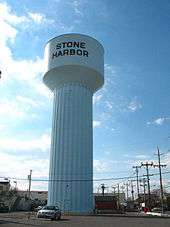
The Stone Harbor Water Tower pumping station, built in 1924, is the oldest municipal structure still in use in Stone Harbor. The tower, 133 feet (41 m) high, can be seen from almost anywhere on the island. It holds 500,000 US gallons (1,900,000 l; 420,000 imp gal) of water and is supplied by four individual fresh water wells 890 feet (270 m) deep that tap the Kirkwood-Cohansey aquifer.[83] In 2005, artist Peter Max developed a plan to cover the water tower with a mural made up of digital version of his paintings and artworks that covered 30 by 170 feet (9.1 by 51.8 m) that would be glued to the tower from June through September, with facsimiles of the art sold through Ocean Galleries as a fundraiser to benefit The Wetlands Institute and other charities.[21]
Stone Harbor attractions include The Wetlands Institute,[84] the Stone Harbor Bird Sanctuary[85] and the Stone Harbor Museum.[86] The Sisters, Servants of the Immaculate Heart of Mary, maintain the Villa Maria by the Sea convent, which opened in June 1937. The beach fronting the Villa is called Nun's Beach and is a well known surfing spot.[87]
It was ranked the tenth-best beach in New Jersey in the 2008 Top 10 Beaches Contest sponsored by the New Jersey Marine Sciences Consortium.[88]
Notable people
People who were born in, residents of, or otherwise closely associated with Stone Harbor include:
- Joseph Hergesheimer (1880-1954), writer of the early 20th century known for his naturalistic novels of decadent life among the very wealthy.[89]
- Clarence Charles Newcomer (1923-2005), United States federal judge.[90]
- Taylor Swift (born 1989), summered until age 14, describing Stone Harbor as a "pretty magical place to grow up."[91]
References
- 1 2 3 4 5 6 2010 Census Gazetteer Files: New Jersey County Subdivisions, United States Census Bureau. Accessed May 21, 2015.
- 1 2 US Gazetteer files: 2010, 2000, and 1990, United States Census Bureau. Accessed September 4, 2014.
- 1 2 2012 New Jersey Legislative District Data Book, Rutgers University Edward J. Bloustein School of Planning and Public Policy, March 2013, p. 8.
- 1 2 Borough Council Standing Committees, Stone Harbor, New Jersey. Accessed June 29, 2016.
- ↑ 2016 New Jersey Mayors Directory, New Jersey Department of Community Affairs. Accessed June 14, 2016.
- ↑ Department of Administration, Borough of Stone Harbor. Accessed June 29, 2016.
- ↑ Borough Clerk, Borough of Stone Harbor. Accessed June 29, 2016.
- ↑ U.S. Geological Survey Geographic Names Information System: Borough of Stone Harbor, Geographic Names Information System. Accessed March 14, 2013.
- 1 2 3 4 5 6 DP-1 - Profile of General Population and Housing Characteristics: 2010 for Stone Harbor borough, Cape May County, New Jersey, United States Census Bureau. Accessed October 17, 2012.
- 1 2 3 4 Municipalities Grouped by 2011-2020 Legislative Districts, New Jersey Department of State, p. 1. Accessed January 6, 2013.
- 1 2 3 Profile of General Demographic Characteristics: 2010 for Stone Harbor borough, New Jersey Department of Labor and Workforce Development. Accessed October 17, 2012.
- 1 2 PEPANNRES - Annual Estimates of the Resident Population: April 1, 2010 to July 1, 2015 - 2015 Population Estimates for New Jersey municipalities, United States Census Bureau. Accessed May 22, 2016.
- 1 2 GCT-PH1 Population, Housing Units, Area, and Density: 2010 - State -- County Subdivision from the 2010 Census Summary File 1 for New Jersey, United States Census Bureau. Accessed October 17, 2012.
- ↑ Look Up a ZIP Code for Stone Harbor, NJ, United States Postal Service. Accessed December 3, 2011.
- ↑ Zip Codes, State of New Jersey. Accessed August 30, 2013.
- ↑ Area Code Lookup - NPA NXX for Stone Harbor, NJ, Area-Codes.com. Accessed August 30, 2013.
- 1 2 American FactFinder, United States Census Bureau. Accessed September 4, 2014.
- ↑ A Cure for the Common Codes: New Jersey, Missouri Census Data Center. Accessed October 17, 2012.
- ↑ US Board on Geographic Names, United States Geological Survey. Accessed September 4, 2014.
- ↑ Master Plan, Borough of Stone Harbor. Accessed May 22, 2008.
- 1 2 Strauss, Robert. "WORTH NOTING; Stone Harbor Gets A Coat of Many Colors", The New York Times, June 26, 2005. Accessed April 29, 2013.
- 1 2 Lyttle, Bethany. "High & Low | Stone Harbor, N.J. - Fine White Sand and Summer Homes", The New York Times, October 10, 2008. Accessed April 29, 2013.
- ↑ , Forbes, accessed October 8, 2014. Accessed October 13, 2014.
- ↑ Stone Harbor, Cape May, NJ, Forbes. Accessed October 13, 2014.
- ↑ Strauss, Robert. "WORTH NOTING; Feeling Flush, Big Spender? You Must Not Be From Here", The New York Times, May 5, 2002. Accessed August 30, 2013. "It's like this -- Alpine's $1.3 million median house sale over the last 18 months is chump change when compared with Atherton's $3.4 million. Farther down the list are Saddle River (37 on the list, $1.23 million), and the Shore resorts Spring Lake (79, $859,500), Stone Harbor (101, $807,500) and Avalon (141, $686,250)."
- ↑ Snyder, John P. The Story of New Jersey's Civil Boundaries: 1606-1968, Bureau of Geology and Topography; Trenton, New Jersey; 1969. p. 116. Accessed October 17, 2012.
- ↑ Truluck, Leslie. "Grassroots Website 'Capt. Stone's Log' Gives Local Stone Harbor Insight", Cape May County Herald, June 19, 2009. Accessed October 10, 2015. "Koch writes from the persona of Capt. Stone, an English seaman who is credited with having named the borough when he sought refuge in the borough's back bay from a storm."
- ↑ Cole, T. Mark; and Glasgow, Cheryl. Stone Harbor, p. 10. Arcadia Publishing, 2001. ISBN 9780738505220. Accessed October 10, 2015. "Named for an English sea captain who found refuge from a sotrn here, the area was first called Stoneharbor. In 1931, the name was changed to Stone Harbor."
- ↑ Benson, David. "Stone Harbor project shut down after second spill", The Gazette of Middle Township, April 7, 2016. Accessed May 31, 2016. "A Stone Harbor dredging project aimed at removing about 100,000 cubic yards of silt from the borough's back bays has been shut down by the state after two geotubes failed recently at the Stone Harbor marina parking lot, releasing mud which seeped through bulkhead openings and into the North Basin, officials said."
- ↑ Locality Search, State of New Jersey. Accessed May 21, 2015.
- ↑ Areas touching Stone Harbor, MapIt. Accessed October 10, 2015.
- ↑ Census Estimates for New Jersey April 1, 2010 to July 1, 2015, United States Census Bureau. Accessed May 22, 2016.
- ↑ Barnett, Bob. Population Data for Cape May County Municipalities, 1810 - 2000, WestJersey.org, January 6, 2011. Accessed October 17, 2012.
- ↑ Compendium of censuses 1726-1905: together with the tabulated returns of 1905, New Jersey Department of State, 1906. Accessed August 30, 2013.
- ↑ Fifteenth Census of the United States: 1930 - Population Volume I, United States Census Bureau, p. 715. Accessed October 17, 2012.
- ↑ Table 6. New Jersey Resident Population by Municipality: 1930 - 1990, New Jersey Department of Labor and Workforce Development. Accessed June 28, 2015.
- 1 2 3 4 5 Census 2000 Profiles of Demographic / Social / Economic / Housing Characteristics for Stone Harbor borough, New Jersey, United States Census Bureau. Accessed October 17, 2012.
- 1 2 3 4 5 DP-1: Profile of General Demographic Characteristics: 2000 - Census 2000 Summary File 1 (SF 1) 100-Percent Data for Stone Harbor borough, Cape May County, New Jersey, United States Census Bureau. Accessed October 17, 2012.
- ↑ DP03: Selected Economic Characteristics from the 2006-2010 American Community Survey 5-Year Estimates for Stone Harbor borough, Cape May County, New Jersey, United States Census Bureau. Accessed October 13, 2012.
- ↑ Cerra, Michael F. "Forms of Government: Everything You've Always Wanted to Know, But Were Afraid to Ask", New Jersey State League of Municipalities. Accessed November 30, 2014.
- ↑ "Forms of Municipal Government in New Jersey", p. 6. Rutgers University Center for Government Studies. Accessed June 3, 2015.
- ↑ 2016 Municipal User Friendly Budget, Stone Harbor, New Jersey. Accessed June 29, 2016.
- ↑ The Official Cape May County 2015 Directory, Cape May County, New Jersey. Accessed June 27, 2016.
- ↑ 2016 COUNTY & MUNICIPAL ELECTED OFFICIALS Cape May County, NJ -- January 2016, Cape May County, New Jersey, January 12, 2016. Accessed June 27, 2016.
- ↑ Cape May County Statement of Vote 2015 General Election, Cape May County, New Jersey, November 10, 2015. Accessed June 27, 2016.
- ↑ November 4, 2014 Summary Report Cape May County Official Results, Cape May County, New Jersey, November 25, 2014. Accessed June 27, 2016.
- ↑ Cape May County Statement of Vote 2013 General Election, Cape May County, New Jersey, November 13, 2013. Accessed June 27, 2016.
- ↑ Plan Components Report, New Jersey Redistricting Commission, December 23, 2011. Accessed January 6, 2013.
- ↑ 2016 New Jersey Citizen's Guide to Government, p. 64, New Jersey League of Women Voters. Accessed July 20, 2016.
- ↑ Districts by Number for 2011-2020, New Jersey Legislature. Accessed January 6, 2013.
- ↑ Directory of Representatives: New Jersey, United States House of Representatives. Accessed January 5, 2012.
- ↑ About Cory Booker, United States Senate. Accessed January 26, 2015. "He now owns a home and lives in Newark's Central Ward community."
- ↑ Biography of Bob Menendez, United States Senate, January 26, 2015. "He currently lives in Paramus and has two children, Alicia and Robert."
- ↑ Senators of the 114th Congress from New Jersey. United States Senate. Accessed January 26, 2015. "Booker, Cory A. - (D - NJ) Class II; Menendez, Robert - (D - NJ) Class I"
- ↑ Legislative Roster 2016-2017 Session, New Jersey Legislature. Accessed January 17, 2016.
- ↑ "About the Governor". State of New Jersey. Retrieved 2010-01-21.
- ↑ "About the Lieutenant Governor". State of New Jersey. Retrieved 2010-01-21.
- ↑ Freeholders Home Page, Cape May County, New Jersey. Accessed January 9, 2013.
- ↑ Gerald M. Thornton, Cape May County, New Jersey. Accessed May 11, 2015.
- ↑ Leonard C. Desiderio, Cape May County, New Jersey. Accessed May 11, 2015.
- ↑ Kristine Gabor, Cape May County, New Jersey. Accessed May 11, 2015.
- ↑ E. Marie Hayes, Cape May County, New Jersey. Accessed May 11, 2015.
- ↑ Will Morey, Cape May County, New Jersey. Accessed May 11, 2015.
- ↑ Home Page, Cape May County Sheriff. Accessed May 11, 2015.
- ↑ Surrogate, Cape May County, New Jersey. Accessed May 11, 2015.
- ↑ Clerk's Office, Cape May County, New Jersey. Accessed May 11, 2015.
- ↑ Voter Registration Summary - Cape May, New Jersey Department of State Division of Elections, March 23, 2011. Accessed October 17, 2012.
- ↑ "Presidential General Election Results - November 6, 2012 - Cape May County" (PDF). New Jersey Department of Elections. March 15, 2013. Retrieved December 24, 2014.
- ↑ "Number of Registered Voters and Ballots Cast - November 6, 2012 - General Election Results - Cape May County" (PDF). New Jersey Department of Elections. March 15, 2013. Retrieved December 24, 2014.
- ↑ 2008 Presidential General Election Results: Cape May County, New Jersey Department of State Division of Elections, December 23, 2008. Accessed October 17, 2012.
- ↑ 2004 Presidential Election: Cape May County, New Jersey Department of State Division of Elections, December 13, 2004. Accessed October 17, 2012.
- ↑ "Governor - Cape May County" (PDF). New Jersey Department of Elections. January 29, 2014. Retrieved December 24, 2014.
- ↑ "Number of Registered Voters and Ballots Cast - November 5, 2013 - General Election Results - Cape May County" (PDF). New Jersey Department of Elections. January 29, 2014. Retrieved December 24, 2014.
- ↑ 2009 Governor: Cape May County, New Jersey Department of State Division of Elections, December 31, 2009. Accessed October 17, 2012.
- ↑ District information for Stone Harbor School District, National Center for Education Statistics. Accessed April 15, 2015.
- ↑ Avalon Elementary School 2014 School Report Card, New Jersey Department of Education. Accessed April 15, 2015. "The district has entered into a 'send-receive' agreement with the neighboring district on the island to consolidate the instructional programs in the two schools. Stone Harbor houses the K-4 programs for both districts and Avalon houses grades 5-8."
- ↑ Middle Township High School 2015 School Report Card, New Jersey Department of Education. Accessed May 30, 2016. "Middle Township High School is a four-year, accredited, comprehensive high school situated in central Cape May County. The school serves the communities of Middle Township, Dennis Township, Avalon, Stone Harbor, and Woodbine Borough."
- ↑ Home page, Middle Township Public Schools. Accessed May 30, 2016. "The high school is a four-year comprehensive public high school that serves students in ninth through twelfth grades. In addition to students from Middle Township, students from Avalon, Dennis Township, Stone Harbor and Woodbine attend the high school as part of sending/receiving relationships."
- ↑ School Data for Middle Township High School, National Center for Education Statistics. Accessed May 30, 2016.
- ↑ Cape May County Mileage by Municipality and Jurisdiction, New Jersey Department of Transportation, May 2010. Accessed July 18, 2014.
- ↑ Cape May County Bus/Rail Connections, backed up by the Internet Archive as of May 22, 2009. Accessed December 15, 2014.
- ↑ South Jersey Transit Guide, Cross County Connection, as of April 1, 2010. Accessed December 15, 2014.
- ↑ Department of Water & Sewer, Borough of Stone Harbor. Accessed August 30, 2013.
- ↑ About Us, The Wetlands Institute. Accessed August 30, 2013.
- ↑ About the Sanctuary, Stone Harbor Bird Sanctuary. Accessed August 30, 2013.
- ↑ About the Museum, Stone Harbor Museum. Accessed August 12, 2014.
- ↑ Gillin-Schwartz, Megan. "Villa Maria-by-the Sea celebrates 70th Anniversary", Cape May County Herald, July 10, 2007. Accessed August 30, 2013. "On July 8, the Sisters of the Immaculate Heart celebrated the 70th Anniversary of the treasured Villa Maria-by-the Sea retreat home on 111th Street with a celebratory mass for benefactors, and an open house for the public.... The retreat house opened June 20, 1937; a little more than four months after the first piece of lumber was laid."
- ↑ Urgo, Jacqueline L. "Sandy laurels for South JerseySeven of the Top 10 N.J. beaches are in Cape May County", The Philadelphia Inquirer, May 23, 2008. Accessed October 10, 2015. "Neighboring Wildwood Crest came in second, followed by Ocean City, North Wildwood, Cape May, Asbury Park in Monmouth County, Avalon, Point Pleasant Beach in northern Ocean County, Beach Haven in southern Ocean County and Stone Harbor."
- ↑ "J. HERGESHEIMER, NOVELIST, 74, DEAD; Author of 'Java Head,' Best Seller, Wrote 20 Works in a Period of 20 Years; BROUGHT PAST TO LIFE Known as a Historian, He Also Commented on the Foibles of the Twenties", The New York Times, April 26, 1954. Accessed August 22, 2015. "The writer, whose home was in Stone Harbor, is survived by his widow, Dorothy Hemphill Hergesheimer."
- ↑ Martin, Douglas. "Clarence C. Newcomer, a Longtime Federal Judge, Dies at 82", The New York Times, August 25, 2005. Accessed July 8, 2015. "Clarence C. Newcomer, who as a federal judge in Philadelphia for more than three decades won a reputation for no-nonsense jurisprudence in hundreds of cases ranging from civil rights to organized crime to baseball cards, died Monday at his home in Stone Harbor, N.J., near Cape May. He was 82."
- ↑ Strauss, Robert. "Taylor Swift's Stone Harbor; From Coffee Talk gigs to Italian Garden pizza, it was a "pretty magical place to grow up.'", The Philadelphia Inquirer, May 15, 2009. Accessed July 8, 2015. "From the time she was 2 until she was 14, when her family left for Nashville, Taylor Swift's parents had a summer house on the bay in Stone Harbor."
External links
- Stone Harbor Borough website
- Stone Harbor School District
- Stone Harbor School District's 2014–15 School Report Card from the New Jersey Department of Education
- Stone Harbor School District, National Center for Education Statistics
| Preceded by Avalon |
Beaches of New Jersey | Succeeded by North Wildwood |
Municipalities and communities of Cape May County, New Jersey, United States | ||
|---|---|---|
| Cities |  | |
| Boroughs | ||
| Townships | ||
| CDPs | ||
| Other unincorporated communities | ||