Middle Township, New Jersey
| Middle Township, New Jersey | |
|---|---|
| Township | |
| Township of Middle | |
|
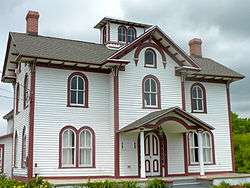
Thomas Beesley Jr. House | |
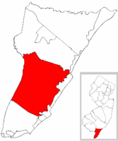 Middle Township highlighted in Cape May County. Inset map: Cape May County highlighted in the State of New Jersey. | |
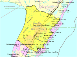 Census Bureau map of Middle Township, New Jersey | |
| Coordinates: 39°05′17″N 74°50′15″W / 39.087952°N 74.837561°WCoordinates: 39°05′17″N 74°50′15″W / 39.087952°N 74.837561°W[1][2] | |
| Country |
|
| State |
|
| County | Cape May |
| Formed | April 2, 1723 |
| Incorporated | February 21, 1798 |
| Government[3] | |
| • Type | Township |
| • Body | Township Committee |
| • Mayor | Michael J. Clark (D, term ends December 31, 2016)[4][5] |
| • Administrator | Connie Mahon[6] |
| • Clerk | Kimberly Krauss[7] |
| Area[1] | |
| • Total | 82.955 sq mi (214.852 km2) |
| • Land | 70.333 sq mi (182.163 km2) |
| • Water | 12.622 sq mi (32.690 km2) 15.22% |
| Area rank |
8th of 566 in state 1st of 16 in county[1] |
| Elevation[8] | 16 ft (5 m) |
| Population (2010 Census)[9][10][11] | |
| • Total | 18,911 |
| • Estimate (2015)[12] | 18,615 |
| • Rank |
135th of 566 in state 2nd of 16 in county[13] |
| • Density | 268.9/sq mi (103.8/km2) |
| • Density rank |
486th of 566 in state 14th of 16 in county[13] |
| Time zone | Eastern (EST) (UTC-5) |
| • Summer (DST) | Eastern (EDT) (UTC-4) |
| ZIP code | 08210 - Cape May Court House[14][15] |
| Area code(s) | 609[16] |
| FIPS code | 3400945810[1][17][18] |
| GNIS feature ID | 0882045[1][19] |
| Website |
www |
Middle Township is a township in Cape May County, New Jersey, United States. It is part of the Ocean City Metropolitan Statistical Area. As of the 2010 United States Census, the township's population was 18,911,[9][10][11] reflecting an increase of 2,506 (+15.3%) from the 16,405 counted in the 2000 Census, which had in turn increased by 1,634 (+11.1%) from the 14,771 counted in the 1990 Census.[20] The township's Cape May Court House section is the county seat of Cape May County.[21][22]
History
Middle Township was formed as a precinct on April 2, 1723, and was incorporated by Township Act of 1798 of the New Jersey Legislature on February 21, 1798 as one of New Jersey's initial group of 104 townships. Portions of the township have been taken to form Anglesea Borough (on June 13, 1885; now North Wildwood City), Avalon Borough (April 18, 1892), Wildwood (May 1, 1895), Stone Harbor Borough (April 3, 1914) and West Wildwood (April 21, 1920).[23] The township's name came from its location when Cape May was split into three townships in 1723 at the same time that Lower Township and Upper Township were created.[24]
Geography
According to the United States Census Bureau, the township had a total area of 82.955 square miles (214.852 km2), including 70.333 square miles (182.163 km2) of land and 12.622 square miles (32.690 km2) of water (15.22%).[1][2]
Burleigh (with a 2010 Census population of 725[25]), Cape May Court House (5,338[26]), Rio Grande (2,670[27]) and Whitesboro (2,205[28]) are unincorporated communities and census-designated places (CDPs) located within Middle Township; Whitesboro and Burleigh had previously been combined for statistical purposes by the Census Bureau as Whitesboro-Burleigh through the 2000 Census.[29] Other unincorporated communities, localities and place names located partially or completely within the township include Del Haven, Dias Creek, Goshen, Goshen Landing, Green Creek, Holly Beach, Mayville, Norburys Landing, Nummytown, Pierces, Pierces Point, Reeds Beach, Shellbed Landing, Swain Point, Swainton, Wildwood Gardens and Wildwood Junction.[30]
The township borders Dennis Township, Sea Isle City, Avalon Borough, Stone Harbor Borough, North Wildwood City, Wildwood City, West Wildwood Borough, Lower Township, the Atlantic Ocean, and the Delaware Bay.
Demographics
| Historical population | |||
|---|---|---|---|
| Census | Pop. | %± | |
| 1810 | 1,106 | — | |
| 1820 | 1,157 | 4.6% | |
| 1830 | 1,366 | 18.1% | |
| 1840 | 1,624 | 18.9% | |
| 1850 | 1,884 | 16.0% | |
| 1860 | 2,155 | 14.4% | |
| 1870 | 2,195 | 1.9% | |
| 1880 | 2,575 | 17.3% | |
| 1890 | 2,368 | * | −8.0% |
| 1900 | 2,191 | * | −7.5% |
| 1910 | 2,974 | 35.7% | |
| 1920 | 2,760 | * | −7.2% |
| 1930 | 3,430 | 24.3% | |
| 1940 | 3,889 | 13.4% | |
| 1950 | 4,599 | 18.3% | |
| 1960 | 6,718 | 46.1% | |
| 1970 | 8,725 | 29.9% | |
| 1980 | 11,373 | 30.3% | |
| 1990 | 14,771 | 29.9% | |
| 2000 | 16,405 | 11.1% | |
| 2010 | 18,911 | 15.3% | |
| Est. 2015 | 18,615 | [12][31] | −1.6% |
| Population sources:1810-2000[32] 1800-1920[33] 1840[34] 1850-1870[35] 1850[36] 1870[37] 1880-1890[38] 1890-1910[39] 1910-1930[40] 1930-1990[41] 2000[42][43] 2010[9][10][11] * = Lost territory in previous decade[23] | |||
2010 Census
At the 2010 United States Census, there were 18,911 people, 7,256 households, and 4,934 families residing in the township. The population density was 268.9 per square mile (103.8/km2). There were 9,296 housing units at an average density of 132.2 per square mile (51.0/km2). The racial makeup of the township was 83.11% (15,716) White, 10.41% (1,969) Black or African American, 0.18% (34) Native American, 1.79% (339) Asian, 0.05% (9) Pacific Islander, 1.97% (373) from other races, and 2.49% (471) from two or more races. Hispanics or Latinos of any race were 5.09% (962) of the population.[9]
There were 7,256 households, of which 24.7% had children under the age of 18 living with them, 50.4% were married couples living together, 12.5% had a female householder with no husband present, and 32.0% were non-families. 26.2% of all households were made up of individuals, and 12.3% had someone living alone who was 65 years of age or older. The average household size was 2.49 and the average family size was 3.00.[9]
In the township, 20.9% of the population were under the age of 18, 7.7% from 18 to 24, 21.9% from 25 to 44, 30.5% from 45 to 64, and 19.0% who were 65 years of age or older. The median age was 44.6 years. For every 100 females there were 94.6 males. For every 100 females age 18 and over, there were 91.7 males.[9]
The Census Bureau's 2006-2010 American Community Survey showed that (in 2010 inflation-adjusted dollars) median household income was $57,244 (with a margin of error of +/- $6,225) and the median family income was $66,451 (+/- $6,897). Males had a median income of $49,645 (+/- $5,272) versus $48,029 (+/- $5,201) for females. The per capita income for the township was $28,087 (+/- $1,866). About 4.4% of families and 6.2% of the population were below the poverty line, including 6.4% of those under age 18 and 5.6% of those age 65 or over.[44]
2000 Census
As of the 2000 United States Census[17] there were 16,405 people, 6,009 households, and 4,218 families residing in the township. The population density was 230.2 people per square mile (88.9/km²). There were 7,510 housing units at an average density of 105.4 per square mile (40.7/km²). The racial makeup of the township was 85.21% White, 10.86% African American, 0.23% Native American, 1.44% Asian, 0.02% Pacific Islander, 0.66% from other races, and 1.58% from two or more races. Hispanic or Latino of any race were 2.12% of the population.[42][43]
There were 6,009 households out of which 31.5% had children under the age of 18 living with them, 53.9% were married couples living together, 12.0% had a female householder with no husband present, and 29.8% were non-families. 24.6% of all households were made up of individuals and 11.9% had someone living alone who was 65 years of age or older. The average household size was 2.58 and the average family size was 3.08.[42][43]
In the township the population was spread out with 24.7% under the age of 18, 6.5% from 18 to 24, 27.8% from 25 to 44, 23.2% from 45 to 64, and 17.8% who were 65 years of age or older. The median age was 40 years. For every 100 females there were 93.1 males. For every 100 females age 18 and over, there were 88.5 males.[42][43]
The median income for a household in the township was $41,533, and the median income for a family was $49,030. Males had a median income of $37,531 versus $27,166 for females. The per capita income for the township was $19,805. About 8.6% of families and 10.2% of the population were below the poverty line, including 14.5% of those under age 18 and 10.6% of those age 65 or over.[42][43]
Government
Local government
Middle Township is governed under the Township form of government. The governing body is a three-member Township Committee, whose members are elected directly by the voters at-large in partisan elections to serve three-year terms of office on a staggered basis, with one seat coming up for election each year as part of the November general election in a three-year cycle.[3][45] At an annual reorganization meeting, the Township Committee selects one of its members to serve as Mayor and another as Deputy Mayor.
As of 2016, the Township Committee consists of Mayor Michael J. Clark (D, term on committee and as mayor ends December 31, 2016), Deputy Mayor Jeffrey DeVico (D, term on committee ends 2018; term as deputy mayor ends 2016) and Committeeman Timothy C. Donohue (R, 2017).[4][46][47][48][49][50][51]
Federal, state and county representation
Middle Township is located in the 2nd Congressional District[52] and is part of New Jersey's 1st state legislative district.[10][53][54]
New Jersey's Second Congressional District is represented by Frank LoBiondo (R, Ventnor City).[55] New Jersey is represented in the United States Senate by Cory Booker (D, Newark, term ends 2021)[56] and Bob Menendez (D, Paramus, 2019).[57][58]
For the 2016–2017 session (Senate, General Assembly), the 1st Legislative District of the New Jersey Legislature is represented in the State Senate by Jeff Van Drew (D, Dennis Township) and in the General Assembly by Bob Andrzejczak (D, Middle Township) and R. Bruce Land (D, Vineland).[59] The Governor of New Jersey is Chris Christie (R, Mendham Township).[60] The Lieutenant Governor of New Jersey is Kim Guadagno (R, Monmouth Beach).[61]
Cape May County is governed by a Board of Chosen Freeholders consisting of five members, elected at-large in partisan elections to three-year terms of office on a staggered basis, with one or two seats coming up for election each year; At an annual reorganization held each January, the freeholders select one member to serve as Director and another to serve as Vice-Director.[62] As of 2015, Cape May County's Freeholders are Freeholder Director Gerald M. Thornton (Middle Township, term ends December 31, 2016),[63] Freeholder Vice-Director Leonard C. Desiderio (Sea Isle City, 2015),[64] Kristine Gabor (Upper Township, 2017)[65], E. Marie Hayes (Ocean City, 2016),[66] and Will Morey (Wildwood Crest, 2017).[67] The county's constitutional officers are Sheriff Gary Schafer (Middle Township, 2017),[68] Surrogate M. Susan Sheppard (Ocean City, 2017),[69] and County Clerk Rita Fulginiti (Ocean City, 2015).[70]
Politics
As of March 23, 2011, there were a total of 12,114 registered voters in Middle Township, of which 3,041 (25.1%) were registered as Democrats, 3,823 (31.6%) were registered as Republicans and 5,244 (43.3%) were registered as Unaffiliated. There were 6 voters registered to other parties.[71]
In the 2012 presidential election, Republican Mitt Romney received 49.6% of the vote (4,328 cast), ahead of Democrat Barack Obama with 49.3% (4,299 votes), and other candidates with 1.1% (93 votes), among the 8,796 ballots cast by the township's 12,717 registered voters (76 ballots were spoiled), for a turnout of 69.2%.[72][73] In the 2008 presidential election, Republican John McCain received 49.5% of the vote (4,483 cast), ahead of Democrat Barack Obama, who received 48.4% (4,389 votes), with 9,059 ballots cast among the township's 11,493 registered voters, for a turnout of 78.8%.[74] In the 2004 presidential election, Republican George W. Bush received 54.0% of the vote (4,391 ballots cast), outpolling Democrat John Kerry, who received around 44.1% (3,586 votes), with 8,133 ballots cast among the township's 10,977 registered voters, for a turnout percentage of 74.1.[75]
In the 2013 gubernatorial election, Republican Chris Christie received 67.5% of the vote (3,856 cast), ahead of Democrat Barbara Buono with 30.8% (1,757 votes), and other candidates with 1.7% (98 votes), among the 5,911 ballots cast by the township's 12,651 registered voters (200 ballots were spoiled), for a turnout of 46.7%.[76][77] In the 2009 gubernatorial election, Republican Chris Christie received 48.4% of the vote (3,024 ballots cast), ahead of both Democrat Jon Corzine with 41.5% (2,593 votes) and Independent Chris Daggett with 6.1% (381 votes), with 6,244 ballots cast among the township's 12,320 registered voters, yielding a 50.7% turnout.[78]
Education
The Middle Township Public Schools serve students in Kindergarten through twelfth grade. As of the 2011-12 school year, the district's four schools had an enrollment of 2,712 students and 217.1 classroom teachers (on an FTE basis), for a student–teacher ratio of 12.49:1.[79] Schools in the district (with 2011-12 enrollment data from the National Center for Education Statistics[80]) are Middle Township Elementary School #1[81] for grades PreK-2 (676 students), Middle Township Elementary School #2[82] for grades 3-5 (559 students), Middle Township Middle School[83] for grades 6-8 (543 students) and Middle Township High School[84] for grades 9-12 (934 students).[85] Students from Avalon, Dennis Township, Stone Harbor and Woodbine attend the district's high school as part of sending/receiving relationships.[86][87]
The district was categorized in 2005 as being "In Need of Improvement" under the terms of the No Child Left Behind Act.[88]
Bishop McHugh Regional Catholic School is a K-8 elementary school that operates under the auspices of the Roman Catholic Diocese of Camden and is supported by four parishes in Cape May County.[89][90]
Infrastructure
Transportation
Roads and highways
As of May 2010, the township had a total of 178.86 miles (287.85 km) of roadways, of which 96.20 miles (154.82 km) were maintained by the municipality, 42.23 miles (67.96 km) by Cape May County, 29.06 miles (46.77 km) by the New Jersey Department of Transportation and 11.37 miles (18.30 km) by the New Jersey Turnpike Authority.[91]
Public transportation
NJ Transit offers bus service between Cape May and Philadelphia on the 313, 315 and 316 (seasonal only) routes, between Cape May and the Port Authority Bus Terminal in Midtown Manhattan on the 319 and between Cape May and Atlantic City on the 552 route.[92][93]
Health care
Cape Regional Medical Center, located in Cape May Court House, is the only hospital in Cape May County. It was known as Burdette Tomlin Memorial Hospital until April 2007.[94]
Wineries
Notable people
People who were born in, residents of, or otherwise closely associated with Middle Township include:
- Bob Andrzejczak (since 1986), politician who has represented the 1st Legislative District in the New Jersey General Assembly since March 2013.[95]
- Kevin Bramble (born 1972), disabled ski racer, freeskier, and monoski designer/builder.[96]
- Maurice Catarcio (1929–2005), professional wrestler for the World Wrestling Federation and record holder in The Guinness Book of World Records.[97]
- Daniel Cohen (born 1936), children's writer.[98]
- Stedman Graham (born 1951), educator, author, businessman and speaker, abest known as the partner of media mogul Oprah Winfrey.[99]
- LaMarr Greer (born 1976), retired basketball player who played in the United States Basketball League and the International Basketball League.[100]
- Matthew Szczur (born 1989), center fielder for the Chicago Cubs.[101]
- Andrew J. Tomlin (1845-1906), awarded the Medal of Honor for his actions in the Civil War.[102]
References
- 1 2 3 4 5 6 2010 Census Gazetteer Files: New Jersey County Subdivisions, United States Census Bureau. Accessed May 21, 2015.
- 1 2 US Gazetteer files: 2010, 2000, and 1990, United States Census Bureau. Accessed September 4, 2014.
- 1 2 2012 New Jersey Legislative District Data Book, Rutgers University Edward J. Bloustein School of Planning and Public Policy, March 2013, p. 9.
- 1 2 Administration, Middle Township. Accessed June 28, 2016.
- ↑ 2016 New Jersey Mayors Directory, New Jersey Department of Community Affairs. Accessed June 14, 2016.
- ↑ Directory, Middle Township. Accessed June 28, 2016.
- ↑ Clerk / Registrar, Middle Township. Accessed June 28, 2016.
- ↑ U.S. Geological Survey Geographic Names Information System: Township of Middle, Geographic Names Information System. Accessed March 8, 2013.
- 1 2 3 4 5 6 DP-1 - Profile of General Population and Housing Characteristics: 2010 for Middle township, Cape May County, New Jersey, United States Census Bureau. Accessed October 17, 2012.
- 1 2 3 4 Municipalities Grouped by 2011-2020 Legislative Districts, New Jersey Department of State, p. 1. Accessed January 6, 2013.
- 1 2 3 Profile of General Demographic Characteristics: 2010 for Middle township, New Jersey Department of Labor and Workforce Development. Accessed October 17, 2012.
- 1 2 PEPANNRES - Annual Estimates of the Resident Population: April 1, 2010 to July 1, 2015 - 2015 Population Estimates for New Jersey municipalities, United States Census Bureau. Accessed May 22, 2016.
- 1 2 GCT-PH1 Population, Housing Units, Area, and Density: 2010 - State -- County Subdivision from the 2010 Census Summary File 1 for New Jersey, United States Census Bureau. Accessed October 17, 2012.
- ↑ Look Up a ZIP Code for Cape May Court House, NJ, United States Postal Service. Accessed October 17, 2012.
- ↑ Zip Codes, State of New Jersey. Accessed September 24, 2013.
- ↑ Area Code Lookup - NPA NXX for Cape May Court House, NJ, Area-Codes.com. Accessed September 24, 2013.
- 1 2 American FactFinder, United States Census Bureau. Accessed September 4, 2014.
- ↑ A Cure for the Common Codes: New Jersey, Missouri Census Data Center. Accessed October 17, 2012.
- ↑ US Board on Geographic Names, United States Geological Survey. Accessed September 4, 2014.
- ↑ Table 7. Population for the Counties and Municipalities in New Jersey: 1990, 2000 and 2010, New Jersey Department of Labor and Workforce Development, February 2011. Accessed October 17, 2012.
- ↑ Find a County, National Association of Counties. Accessed December 18, 2014.
- ↑ Cape May County, NJ, National Association of Counties. Accessed January 20, 2013.
- 1 2 Snyder, John P. The Story of New Jersey's Civil Boundaries: 1606-1968, Bureau of Geology and Topography; Trenton, New Jersey; 1969. p. 114. Accessed May 1, 2012.
- ↑ Stevens, Lewis Townsend. The History of Cape May County, New Jersey: From the Aboriginal Times to the Present Day, p. 92. L.T. Stevens, 1897. Accessed September 3, 2015. "The county of Cape May was divided into three townships, Upper, Middle and Lower, April 2, 1723, of which the official record says:"
- ↑ DP-1 - Profile of General Population and Housing Characteristics: 2010 Demographic Profile Data for Burleigh CDP, New Jersey, United States Census Bureau. Accessed May 1, 2012.
- ↑ DP-1 - Profile of General Population and Housing Characteristics: 2010 Demographic Profile Data for Cape May Court House CDP, New Jersey, United States Census Bureau. Accessed May 1, 2012.
- ↑ DP-1 - Profile of General Population and Housing Characteristics: 2010 Demographic Profile Data for Rio Grande CDP, New Jersey, United States Census Bureau. Accessed May 1, 2012.
- ↑ DP-1 - Profile of General Population and Housing Characteristics: 2010 Demographic Profile Data for Whitesboro CDP, New Jersey, United States Census Bureau. Accessed May 1, 2012.
- ↑ New Jersey: 2010 - Population and Housing Unit Counts - 2010 Census of Population and Housing (CPH-2-32), United States Census Bureau, August 2012. Accessed October 17, 2012.
- ↑ Locality Search, State of New Jersey. Accessed December 18, 2014.
- ↑ Census Estimates for New Jersey April 1, 2010 to July 1, 2015, United States Census Bureau. Accessed May 22, 2016.
- ↑ Barnett, Bob. Population Data for Cape May County Municipalities, 1810 - 2000, WestJersey.org, January 6, 2011. Accessed October 17, 2012.
- ↑ Compendium of censuses 1726-1905: together with the tabulated returns of 1905, New Jersey Department of State, 1906. Accessed July 9, 2013.
- ↑ Bowen, Francis. American Almanac and Repository of Useful Knowledge for the Year 1843, p. 232, David H. Williams, 1842. Accessed July 9, 2013.
- ↑ Raum, John O. The History of New Jersey: From Its Earliest Settlement to the Present Time, Volume 1, p. 261, J. E. Potter and company, 1877. Accessed July 9, 2013. "Middle township was incorporated in 1798 and contained in 1850, 1,884 inhabitants; in 1860, 2,155; and in 1870, 3,443. About one half of this township is salt marsh or sea beach. It extends across the township from the Atlantic ocean to Delaware bay. Goshen is a post village about five miles northwest of the court house and contains about twenty five dwellings. The post village of Cape May Court House is in the central part of the county between Great Sound and Jenkins Sound and about eighty miles from Trenton in a straight line. It contained in 1870 1,348 inhabitants."
- ↑ Debow, James Dunwoody Brownson. The Seventh Census of the United States: 1850, p. 138. R. Armstrong, 1853. Accessed July 9, 2013.
- ↑ Staff. A compendium of the ninth census, 1870, p. 259. United States Census Bureau, 1872. Accessed July 9, 2013.
- ↑ Porter, Robert Percival. Preliminary Results as Contained in the Eleventh Census Bulletins: Volume III - 51 to 75, p. 97. United States Census Bureau, 1890. Accessed July 9, 2013.
- ↑ Thirteenth Census of the United States, 1910: Population by Counties and Minor Civil Divisions, 1910, 1900, 1890, United States Census Bureau, p. 335. Accessed July 9, 2013.
- ↑ Fifteenth Census of the United States : 1930 - Population Volume I, United States Census Bureau, p. 714. Accessed July 9, 2013.
- ↑ Table 6. New Jersey Resident Population by Municipality: 1930 - 1990, New Jersey Department of Labor and Workforce Development. Accessed June 28, 2015.
- 1 2 3 4 5 Census 2000 Profiles of Demographic / Social / Economic / Housing Characteristics for Middle township, Cape May County, New Jersey, United States Census Bureau. Accessed May 1, 2012.
- 1 2 3 4 5 DP-1: Profile of General Demographic Characteristics: 2000 - Census 2000 Summary File 1 (SF 1) 100-Percent Data for Middle township, Cape May County, New Jersey, United States Census Bureau. Accessed October 17, 2012.
- ↑ DP03: Selected Economic Characteristics from the 2006-2010 American Community Survey 5-Year Estimates for Middle Township, Cape May County, New Jersey, United States Census Bureau. Accessed October 17, 2012.
- ↑ "Forms of Municipal Government in New Jersey", p. 7. Rutgers University Center for Government Studies. Accessed June 3, 2015.
- ↑ 2016 Municipal Data Sheet, Middle Township. Accessed June 28, 2016.
- ↑ The Official Cape May County 2015 Directory, Cape May County, New Jersey. Accessed June 27, 2016.
- ↑ 2016 COUNTY & MUNICIPAL ELECTED OFFICIALS Cape May County, NJ -- January 2016, Cape May County, New Jersey, January 12, 2016. Accessed June 27, 2016.
- ↑ Cape May County Statement of Vote 2015 General Election, Cape May County, New Jersey, November 10, 2015. Accessed June 27, 2016.
- ↑ November 4, 2014 Summary Report Cape May County Official Results, Cape May County, New Jersey, November 25, 2014. Accessed June 27, 2016.
- ↑ Cape May County Statement of Vote 2013 General Election, Cape May County, New Jersey, November 13, 2013. Accessed June 27, 2016.
- ↑ Plan Components Report, New Jersey Redistricting Commission, December 23, 2011. Accessed January 6, 2013.
- ↑ 2016 New Jersey Citizen's Guide to Government, p. 60, New Jersey League of Women Voters. Accessed July 20, 2016.
- ↑ Districts by Number for 2011-2020, New Jersey Legislature. Accessed January 6, 2013.
- ↑ Directory of Representatives: New Jersey, United States House of Representatives. Accessed January 5, 2012.
- ↑ About Cory Booker, United States Senate. Accessed January 26, 2015. "He now owns a home and lives in Newark's Central Ward community."
- ↑ Biography of Bob Menendez, United States Senate, January 26, 2015. "He currently lives in Paramus and has two children, Alicia and Robert."
- ↑ Senators of the 114th Congress from New Jersey. United States Senate. Accessed January 26, 2015. "Booker, Cory A. - (D - NJ) Class II; Menendez, Robert - (D - NJ) Class I"
- ↑ Legislative Roster 2016-2017 Session, New Jersey Legislature. Accessed January 17, 2016.
- ↑ "About the Governor". State of New Jersey. Retrieved 2010-01-21.
- ↑ "About the Lieutenant Governor". State of New Jersey. Retrieved 2010-01-21.
- ↑ Freeholders Home Page, Cape May County, New Jersey. Accessed January 9, 2013.
- ↑ Gerald M. Thornton, Cape May County, New Jersey. Accessed May 11, 2015.
- ↑ Leonard C. Desiderio, Cape May County, New Jersey. Accessed May 11, 2015.
- ↑ Kristine Gabor, Cape May County, New Jersey. Accessed May 11, 2015.
- ↑ E. Marie Hayes, Cape May County, New Jersey. Accessed May 11, 2015.
- ↑ Will Morey, Cape May County, New Jersey. Accessed May 11, 2015.
- ↑ Home Page, Cape May County Sheriff. Accessed May 11, 2015.
- ↑ Surrogate, Cape May County, New Jersey. Accessed May 11, 2015.
- ↑ Clerk's Office, Cape May County, New Jersey. Accessed May 11, 2015.
- ↑ Voter Registration Summary - Cape May, New Jersey Department of State Division of Elections, March 23, 2011. Accessed October 17, 2012.
- ↑ "Presidential General Election Results - November 6, 2012 - Cape May County" (PDF). New Jersey Department of Elections. March 15, 2013. Retrieved December 24, 2014.
- ↑ "Number of Registered Voters and Ballots Cast - November 6, 2012 - General Election Results - Cape May County" (PDF). New Jersey Department of Elections. March 15, 2013. Retrieved December 24, 2014.
- ↑ 2008 Presidential General Election Results: Cape May County, New Jersey Department of State Division of Elections, December 23, 2008. Accessed October 17, 2012.
- ↑ 2004 Presidential Election: Cape May County, New Jersey Department of State Division of Elections, December 13, 2004. Accessed October 17, 2012.
- ↑ "Governor - Cape May County" (PDF). New Jersey Department of Elections. January 29, 2014. Retrieved December 24, 2014.
- ↑ "Number of Registered Voters and Ballots Cast - November 5, 2013 - General Election Results - Cape May County" (PDF). New Jersey Department of Elections. January 29, 2014. Retrieved December 24, 2014.
- ↑ 2009 Governor: Cape May County, New Jersey Department of State Division of Elections, December 31, 2009. Accessed October 17, 2012.
- ↑ District information for Middle Township School District, National Center for Education Statistics. Accessed December 18, 2014.
- ↑ School Data for the Middle Township Public Schools, National Center for Education Statistics. Accessed December 18, 2014.
- ↑ Middle Township Elementary School #1, Middle Township Public Schools. Accessed December 18, 2014.
- ↑ Middle Township Elementary School #2, Middle Township Public Schools. Accessed December 18, 2014.
- ↑ Middle Township Middle School, Middle Township Public Schools. Accessed December 18, 2014.
- ↑ Middle Township High School, Middle Township Public Schools. Accessed December 18, 2014.
- ↑ New Jersey School Directory for the Middle Township Public Schools, New Jersey Department of Education. Accessed September 24, 2013.
- ↑ Middle Township High School 2015 School Report Card, New Jersey Department of Education. Accessed May 30, 2016. "Middle Township High School is a four-year, accredited, comprehensive high school situated in central Cape May County. The school serves the communities of Middle Township, Dennis Township, Avalon, Stone Harbor, and Woodbine Borough."
- ↑ Home page, Middle Township Public Schools. Accessed May 30, 2016. "The high school is a four-year comprehensive public high school that serves students in ninth through twelfth grades. In addition to students from Middle Township, students from Avalon, Dennis Township, Stone Harbor and Woodbine attend the high school as part of sending/receiving relationships."
- ↑ DOE Finalizes "Districts In Need of Improvement" List, New Jersey Department of Education press release, April 20, 2005. Accessed July 22, 2007.
- ↑ Catholic Schools Directory, Roman Catholic Diocese of Camden. Accessed October 20, 2016.
- ↑ Welcome, Bishop McHugh Regional Catholic School. Accessed October 20, 2016. "The school is part of the Diocese of Camden, and is supported by the four regional parishes of Avalon/Stone Harbor, Cape May Court House, Marmora/Woodbine and Sea Isle City."
- ↑ Cape May County Mileage by Municipality and Jurisdiction, New Jersey Department of Transportation, May 2010. Accessed July 18, 2014.
- ↑ Cape May Bus / Rail Connections, NJ Transit, backed up by the Internet Archive as of January 28, 2010. Accessed October 2, 2014.
- ↑ South Jersey Transit Guide, Cross County Connection, as of April 1, 2010. Accessed October 2, 2014.
- ↑ Ianieri, Brian. "Bye bye, Burdette: Hospital has new name / Switch to Cape Regional Medical Center reflects new services, officials say", The Press of Atlantic City, April 3, 2007. Accessed October 17, 2012. "Burdette Tomlin Memorial Hospital's name became history Monday morning, as Cape May County's only hospital changed its name abruptly to Cape Regional Medical Center."
- ↑ Assemblyman Bob Andrzejczak – 1st District, Atlantic County Democrats. Accessed December 18, 2014. "Democrat Robert 'Bob' Andrzejczak, of Middle Township, was first sworn into the New website andrzejczakJersey General Assembly on March 21, 2013, filling the unexpired term of Matthew W. Milam."
- ↑ Berg, Aimee. "Disabled Skier Designs His Way to Be a Daredevil", The New York Times, December 13, 2006. Accessed September 24, 2013. "These days, Bramble builds the 32-pound aluminum and steel contraptions in a converted woodshop behind the two-story home that he built for his parents in Cape May Court House, N.J., before the accident. He and his fiancée, Leslie, live in an apartment above the shop, which he reaches via an open-air elevator that he also engineered."
- ↑ via Associated Press. "Maurice Catarcio; ex-pro wrestler did strength feats", The Boston Globe, May 16, 2005. Accessed November 22, 2016. "MIDDLE TOWNSHIP, N.J. -- Maurice Catarcio, a former professional wrestler and weightlifter who gained national fame after he was diagnosed with cancer in his later years, has died. He was 76. Mr. Catarcio died of cancer at his home in Del Haven on Thursday."
- ↑ Degener, Richard. "Middle Township mother rejoices in Gadhafi's death". Press of Atlantic City. October 20, 2011. Accessed April 29, 2012.
- ↑ Jackson, Vincent. "Oprah Winfrey stumps for Cory Booker at Whitesboro Reunion", The Press of Atlantic City, August 31, 2013. Accessed December 18, 2014. "Stedman Graham is a Whitesboro native and executive director of the Concerned Citizens of Whitesboro."
- ↑ McGarry, Michael. "European basketball star LaMarr Greer remembers his roots in Middle Township", The Press of Atlantic City, July 2, 2010. Accessed August 15, 2016. "The photographs on the wall of LaMarr Greer's Middle Township home tell the story of his basketball travels."
- ↑ Matthew Szczur, Villanova Wildcats football. Accessed December 18, 2014. "Personal: Born 7/20/89 in Cape May Court House, N.J."
- ↑ Andrew J. Tomlin, Congressional Medal of Honor Society of the United States of America. Accessed July 9, 2013.
External links
- Middle Township website
- Middle Township Public Schools
- Middle Township Public Schools's 2014–15 School Report Card from the New Jersey Department of Education
- School Data for the Middle Township Public Schools, National Center for Education Statistics
- Middle Township Gazette Local community newspaper
Municipalities and communities of Cape May County, New Jersey, United States | ||
|---|---|---|
| Cities | 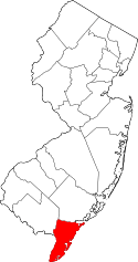 | |
| Boroughs | ||
| Townships | ||
| CDPs | ||
| Other unincorporated communities | ||