Stone Nullah Lane
| <span class="nickname" ">石水渠街 | |
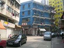
 The northern end of Stone Nullah Lane at the junction with Queen's Road East. The Blue House can be seen in the background (left). | |
| Length | 140 m[1] (460 ft) |
|---|---|
| Location | Wan Chai, Hong Kong |
| South end | Lung On Street |
| North end | Queen's Road East |
.jpg)
Stone Nullah Lane (Chinese: 石水渠街; pinyin: Shí Shuǐqú Jiē; Cantonese Yale: sek6 seoi2 keoi4 gaai1) is a one-way street in Wan Chai, Hong Kong Island, Hong Kong. Named after the water channel previously located on it, it stretches from Lung On Street to Queen's Road East. The street is noted for its historical landmarks, most notably the Blue House and Pak Tai Temple.
History
During the First Opium War, the British occupied Hong Kong in 1841 and one year later, the territory was ceded to them under the Treaty of Nanking. At the time, a nullah or water channel made of stone or concrete was located on the street.[2] It carried a stream that originated from the hills of Victoria Peak situated above Kennedy Road. After travelling down the street, it drained out into Victoria Harbour underneath Wan Chai Road, which was located on Hong Kong Island's waterfront. However, it is now situated much farther inland due to land reclamation that has been undertaken since its opening.[2] The structure eventually lent its name to the street it was built on,[3] and it was common for laundry to be washed in the nullah.[2]
At the start of the 20th century, shops that processed soybeans were established near Stone Nullah Lane. Because of the unpleasant odour emitted during the processing, this led to protests from residents in the neighbourhood. Eventually, the shops were forced to move to other areas.[2] The nullah, which also emitted a foul stench,[3] was relocated underground, where the stream from The Peak still flows today.[2] Although the nullah can no longer be found on the lane, the street name was left unchanged.[3]
Description and features
From its southern end, Stone Nullah Lane begins at its junction with Lung On Street. This is where the Pak Tai Temple is located.[4] Made from grey-coloured brick and granite, it was constructed in 1863,[5] although the statue of Pak Tai inside dates even further back to 1604.[6] The temple is the oldest in the district,[7] and reportedly the largest on Hong Kong Island.[5] The next landmark on the route is the headquarters of St. James' Settlement. Situated at 85 Stone Nullah Lane,[8] the charitable organisation was established here in 1949 with the goal of helping impoverished children living in squats around the neighbourhood, and now extends its services to needy people across the city. The current structure towers 12-storeys above the lane.[6] Before the street turns onto Queen's Road East and ends, it passes the Blue House, a Grade I historic building.[9] The building—whose Spanish balconies made from cast-iron have elicited comparisons to ones in New Orleans[10]—was built in the 1920s and was originally utilised as a health centre for the community, a school teaching kung fu from the 1950s to 1960s,[7] and now houses a museum.[7][10]
See also
References
- ↑ Google (28 January 2014). "Stone Nullah Lane" (Map). Google Maps. Google. Retrieved 28 January 2014.
- 1 2 3 4 5 Wordie, Jason (1 March 2002). Streets: Exploring Hong Kong Island. Hong Kong University Press. pp. 135–138. Retrieved 8 January 2014.
- 1 2 3 Wordie, Jason (20 January 2008). "FYI: Why do some Hong Kong street names seem to have no connection to the area they are in?". South China Morning Post. p. 10. Retrieved 8 January 2014. (subscription required)
- ↑ Brown, Jules (2002). Hong Kong and Macau. Rough Guides. p. 89. Retrieved 7 January 2014.
- 1 2 Bailey, Steven K. (1 November 2009). Exploring Hong Kong: A Visitor's Guide to Hong Kong Island, Kowloon, and the New Territories. ThingsAsian Press. p. 87. Retrieved 7 January 2014.
- 1 2 Evans, Annemarie (26 August 2006). "Eye on Wan Chai". South China Morning Post. p. 2. Retrieved 7 January 2014. (subscription required)
- 1 2 3 Barrett, Rosanne (26 February 2010). "City Walk: Hong Kong". Wall Street Journal. Retrieved 8 January 2014. (subscription required)
- ↑ Lau, Kit Wai (27 November 2005). "St James' Settlement". South China Morning Post. p. 11. Retrieved 8 January 2014. (subscription required)
- ↑ "List of the 1,444 Historic Buildings in Building Assessment (as of 27 December 2013)" (PDF). Antiquities Advisory Board. Government of Hong Kong. Retrieved 8 January 2014.
- 1 2 Chen, Piera (1 February 2013). Lonely Planet Pocket Hong Kong. Lonely Planet. Retrieved 8 January 2014.
External links
| Wikimedia Commons has media related to Stone Nullah Lane. |
From East to West | ||||||||
| Queen's Road East |
|   | ||||||
| Queensway |
| |||||||
| Queen's Road Central |
| |||||||
| Queen's Road West | ||||||||
Coordinates: 22°16′26″N 114°10′26″E / 22.2740°N 114.1740°E