Route 1 (Hong Kong)
| ||||
|---|---|---|---|---|
|
Route 1 coloured red | ||||
| Route information | ||||
| Maintained by Highways Department | ||||
| Length: |
20.7 km (12.9 mi) 20.6 kilometres (12.8 mi) South | |||
| Existed: | 1966 (Princess Margaret Road) – present | |||
| Major junctions | ||||
| South end: | Aberdeen Praya Road, Aberdeen | |||
|
Sha Lek Highway, Sha Tin Wai | ||||
| North end: |
| |||
| Location | ||||
| Districts: | Southern, Central and Western, Wan Chai, Yau Tsim Mong, Kowloon City, Wong Tai Sin, Sha Tin | |||
| Highway system | ||||
|
Hong Kong Strategic Route and Exit Number System
| ||||

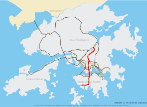
Route 1 (Chinese: 一號幹線) is a major artery in Hong Kong that runs in a generally north-south direction, connecting Aberdeen with Shatin.
The route is heavily congested, notably on the Canal Road viaduct that links the Aberdeen Tunnel with the Cross-Harbour Tunnel in Causeway Bay.[1] Route 1 continues to serve as the most direct route from the north shore of Hong Kong Island to the Southern District. The road travels across the harbour and runs through the middle of Kowloon and continues heading north into the New Territories.
History
Route 1 was established in January 2004 when the third generation of route numbers came into use, replacing the old system which had been used since 1974.
Route
Legend | |||||||||||||||||||||||||||||||||||||||||||||||||||||||||||||||||||||||||||||||||||||||||||||||||||||||||||||||||||||||||||||||||||||||||||||||||||||||||||||||||||||||||||||||||||||||||||||||||||||||||||||||||||||||||||||||||||||||||||||||||||||||||||||||||||||||||||||||||||||||||||||
| |||||||||||||||||||||||||||||||||||||||||||||||||||||||||||||||||||||||||||||||||||||||||||||||||||||||||||||||||||||||||||||||||||||||||||||||||||||||||||||||||||||||||||||||||||||||||||||||||||||||||||||||||||||||||||||||||||||||||||||||||||||||||||||||||||||||||||||||||||||||||||||
The route begins in the south at Aberdeen Praya Road which continues as Wong Chuk Hang Road until reaching the Aberdeen Tunnel. The traffic runs on the Canal Road viaduct after exiting the tunnel in Happy Valley. The viaduct descends to the ground level passed the intersection at Gloucester Road for Route 4.
Traffic then crosses the Cross-Harbour Tunnel into Kowloon and keeps heading north along Princess Margaret Road and Waterloo Road. The stretch of Waterloo Road between Hereford Road and Lancashire Road in Kowloon Tong is the only section of the route that is not controlled access. Traffic then climbs a steep incline to reach the Lion Rock Tunnel. At the end of the tunnel, the road skirts the border of Tai Wai. Traffic has an option to merge to Route 9 in Shatin or branch off onto Route 2 for Ma On Shan.[2]
Exits and interchanges
| District | Location | km[3] | mi | Exit | Destinations | Notes |
|---|---|---|---|---|---|---|
| Southern | Aberdeen | 0.0– 0.2 | 0.0– 0.12 | 1 | Ap Lei Chau Bridge / Aberdeen Praya Road | Trumpet interchange; Southern terminus |
| Wong Chuk Hang | 0.2 | 0.12 | 1A | Heung Yip Road | Southbound only | |
| 0.4 | 0.25 | — | Yip Kan Street | Yip Kan Street to southbound only | ||
| 0.5– 1.1 | 0.31– 0.68 | 2 | Wong Chuk Hang Road to Nam Long Shan Road | |||
| 1.2– 1.3 | 0.75– 0.81 | 3 | Ocean Park Road | Trumpet interchange | ||
| 1.4– 2.0 | 0.87– 1.2 | 4 | Wong Chuk Hang Road / Nam Fung Road | No access to/from southbound | ||
| 2.1 | 1.3 | Aberdeen Tunnel Toll Plaza | ||||
| Southern– Wan Chai | Wong Chuk Hang– Happy Valley | 2.3– 4.2 | 1.4– 2.6 | Aberdeen Tunnel | ||
| Wan Chai | Morrison Hill | 4.3– 4.9 | 2.7– 3.0 | 5 | Wong Nai Chung Road | To/from Route 1 northbound only |
| East Point | 5.3 | 3.3 | 5A | Canal Road West / Canal Road East | To/from Route 1 southbound only | |
| 5.4– 5.9 | 3.4– 3.7 | 6 | ||||
| Wan Chai– Yau Tsim Mong | East Point– Hung Hom Bay | 6.0– 7.8 | 3.7– 4.8 | Cross-Harbour Tunnel | ||
| Yau Tsim Mong | Hung Hom Bay | 8.1 | 5.0 | Cross-Harbour Tunnel Toll Plaza | ||
| 8.2 | 5.1 | — | Hong Chong Road | Hong Chong Road to northbound Route 1 only | ||
| Hung Hom | 8.4 | 5.2 | 6A | Salisbury Road | Southbound only | |
| 6B | Railway Approach | Southbound only | ||||
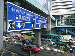
| 6C | Route 1 northbound to Route 5 westbound | |||||
| 8.6 | 5.3 | 6D | Route 1 northbound to Route 5 eastbound | |||
| No. 12 Hill | 9.0 | 5.6 | 7A | Princess Margaret Road | To/from Route 1 northbound only | |
| 7B | Princess Margaret Road Link | To from Route 1 northbound only | ||||
| Kowloon City | 9.1– 9.4 | 5.7– 5.8 | 7D | Chi Man Street | Southbound only | |
| Yau Tsim Mong | 9.3 | 5.8 | 7C | Wylie Road | Northbound only | |
| Kowloon City | 9.7 | 6.0 | 7E | Chung Man Street | Southbound only | |
| Ho Man Tin | 10.0 | 6.2 | 8 | Man Fung Path / Sheung Hing Street to Pui Ching Road | Partial cloverleaf interchange; No access to Route 1 southbound from Pui Ching Road westbound | |
| — | Princess Margaret Road to Argyle Street | To/from southbound Route 1 only | ||||
| Ma Tau Wai | 11.0 | 6.8 | 8A | Waterloo Road | Frontage road | |
| — | Boundary Street | Boundary Street to Route 1 southbound only | ||||
| 8B | Prince Edward Road West | Southbound only | ||||
| Kowloon Tsai | 8C | Waterloo Road | Frontage road | |||
| 8D | Flint Road | Southbound exit only | ||||
| 9 | Essex Crescent / Lancashire Road | Northbound only | ||||
| 12.0 | 7.5 | 9A | Rutland Quadrant / Durham Road | Southbound only | ||
| 9C | Hereford Road | No access from Hereford Road to Route 1 northbound | ||||
| — | York Road | York Road to Route 1 northbound only | ||||
| 9E | Norfolk Road | Northbound exit only | ||||
| 9F | Waterloo Road to Cornwall Street / Junction Road | Frontage road | ||||
| 13.0 | 8.1 | 9G | Waterloo Road / Ede Road | Frontage road; Ede Road to Route 1 northbound only | ||
| 10A | Route 7 westbound to/from Route 1 northbound | |||||
| Kowloon City– Wong Tai Sin | 10B | Route 7 eastbound to/from Route 1 northbound | ||||
| Kowloon City– Sha Tin | Kowloon Tsai– Tai Wai | 14.0– 15.0 | 8.7– 9.3 | Lion Rock Tunnel | ||
| Sha Tin | Tai Wai | 15.0 | 9.3 | Lion Rock Tunnel Toll Plaza | ||
| 16.0 | 9.9 | 11 | Hung Mui Kuk Road | Trumpet interchange | ||
| Sha Tin | 17.0 | 10.6 | 11A | Lion Rock Tunnel Road / Che Kung Miu Road / Tai Chung Kiu Road | To/from Route 1 southbound | |
| 18.0 | 11.2 | 11B | Sha Lek Highway | To/from Route 1 southbound | ||
| 19.0 | 11.8 | 12 | Sha Tin Wai Road | Diamond interchange | ||
| 20.0 | 12.4 | 12A | Fo Tan Road / Tai Chung Kiu Road | To/from Route 1 southbound | ||
| Fo Tan | 21.0 | 13.0 | 12B | Sha Tin Road to Yuen Wo Road | To/from Route 1 southbound | |
| — | To/from Route 9 eastbound; Northern terminus | |||||
1.000 mi = 1.609 km; 1.000 km = 0.621 mi
| ||||||
Notes
References
- ↑ "LCQ4: Traffic congestion along the link roads to the Aberdeen Tunnel". Information Services Department. Retrieved 17 November 2014.
- ↑ "Route Diagram - Route 1". Transport Department. Retrieved 10 January 2014.
- ↑ OpenStreetMap contributors. Route 1 (Map). OpenStreetMap. Retrieved 20 March 2016.