Straits of Mackinac Shipwreck Preserve
| Straits of Mackinac Shipwreck Preserve | |
|---|---|
|
Aerial view of the waters protected within the Straits of Mackinac Shipwreck Preserve. | |
 Location within the state of Michigan | |
| Location | Lake Huron, Lake Michigan, Cheboygan County, Emmet County, Mackinac County, Michigan, USA |
| Nearest city | Mackinaw City, Michigan |
| Coordinates | 45°48′51″N 84°44′56″W / 45.8142°N 84.749°WCoordinates: 45°48′51″N 84°44′56″W / 45.8142°N 84.749°W |
| Area | 148 square miles (380 km2) |
| Governing body | Michigan Department of Natural Resources |
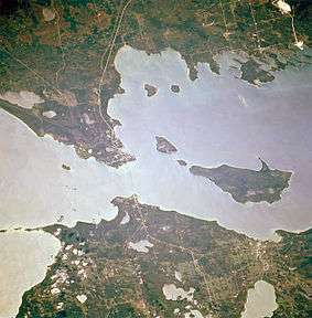
The Straits of Mackinac Shipwreck Preserve is a 148-square-mile (380 km2) state preserve in and around the Straits of Mackinac. The preserve is divided in two by the Mackinac Bridge. The waters of the preserve include the waters offshore from Mackinaw City and St. Ignace, as well as all or part of the shorelines of Bois Blanc Island, Mackinac Island, Round Island, and St. Helena Island.
The preserve contains at least eleven identified wrecks. Frequent fog and congested shipping added to the count of shipwrecks in the Straits area. Half a dozen lighthouses in and around the preserve testify to the dangers that existed prior to the invention of radar in the 1940s. Tragedies have continued, however. One modern wreck within the boundaries of the preserve is the Cedarville, a limestone lake freighter that sank in 1965 after a collision. For more information on the wrecks, see "Shipwrecks of the Straits of Mackinac" by Dr. Charles E. Feltner and Jeri Baron Feltner.
Divers also visit underwater formations of Mackinac breccia near Mackinac Island; one such formation, the Rock Maze, is offshore from Arch Rock. Further east off Arch Rock, a drowned, 100-foot-high (30 m) waterfall formation, Mackinac Falls, was discovered in August 2007.
Known wrecks within the preserve
| Wreck Name | Depth | GPS/LAT/LON |
|---|---|---|
| William H. Barnum | 58’ to 75’ | 45 44.42’N / 084 37.53’W |
| Cayuga | 75’ to 102’ | 45 43.19’N / 085 11.36’W |
| Cedarville | 40’ to 106’ | 45 47.13’N / 084 40.13’W |
| Eber Ward | 111’ to 143’ | 45 48.83’N / 084 49.04’W |
| Fred McBrier | 96’ to 104’ | 45 48.11’N / 085 55.09’W |
| Maitland | 85’ | 45 49.20’N / 085 52.29’W |
| Minneapolis | 124’ | 45 48.32’N / 084 50.08’W |
| Newell Eddy | 165’ | 45 46.89’N / 084 13.81’W |
| Northwest | 75’ | 45 47.32’N / 084 51.30’W |
| Rock Maze | 0 to 35' | 45 54.862’N / 084 36.402’W |
| Sandusky | 70’ to 85’ | 45 48.09’N / 084 50.08’W |
| Martin Stalker | 85' | 45 47.38’N / 084 41.04’ |
| St. Andrew | 62' | 45 42.07’N / 084 31.46’W |
| Uganda | 185' to 207' | 45 50.30’N / 085 03.49’W |
| William Young | 120' | 45 48.79’N / 084 41.91’W |
See also
- Michigan Underwater Preserves
- Old Mackinac Point Light
- Round Island Light (Michigan)
- St. Helena Island Light