Styrian Prealps
| Styrian Prealps | |
|---|---|
| German: Steirisches Randgebirge | |
 The Stuhleck (1,782 m) in winter | |
| Highest point | |
| Peak | Ameringkogel |
| Elevation | 2,184 m (7,165 ft) |
| Coordinates | 47°04′16″N 14°48′30″E / 47.07111°N 14.80833°ECoordinates: 47°04′16″N 14°48′30″E / 47.07111°N 14.80833°E |
| Geography | |
 Styrian Prealps (section nr.20) within Eastern Alps | |
| Countries | Austria, Slovenia and Hungary |
| Settlement | Graz, Maribor |
| Parent range | Alps |
| Borders on | Northern Styrian Alps, Eastern Tauern Alps, Carinthian-Styrian Alps and Slovenian Prealps |
| Geology | |
| Orogeny | Alpine orogeny |
The Styrian Prealps (in German Steirisches Randgebirge, in Slovenian Štajersko Robno hribovje) is the proposed name for a subdivision of mountains in a new, and as yet unadopted, classification of the Alps, located in Austria and, marginally, in Slovenia and Hungary.
Geography
The whole range is drained by the tributaries of the Danube river.
SOIUSA classification
According to SOIUSA (International Standardized Mountain Subdivision of the Alps) the Styrian Prealps are an Alpine section, classified in the following way:[1]
- main part = Eastern Alps
- major sector = Central Eastern Alps
- section = Styrian Prealps
- code = II/A-20
Subdivision
The Styrian Prealps are divided into four subsections:
- North-western Styrian Prealps (Stubalpe; Gleinalpe; Westgraz) - SOIUSA code:II/A-20.I;
- South-western Styrian Prealps (Koralpe; Reinischkögel; Kobansko) - SOIUSA code:II/A-20.II
- Central Styrian Prealps (Fischbach; Ostgraz) - SOIUSA code:II/A-20.III;
- Eastern Styrian Prealps (Wechsel-Joglland; Bucklige; Bernstein-Güns; Rosalien-Ödenburg) - SOIUSA code:II/A-20.IV.
Notable summits
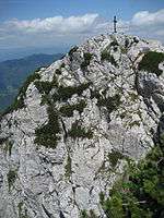
Mount Hochlantsch (1,720 m)
Some notable summits of the Styrian Prealps are:
| Name | metres | feet |
|---|---|---|
| Ameringkogel | 2,184 | 7,164 |
| Großer Speikkogel | 2,140 | 7,019 |
| Stuhleck | 1,782 | 5,845 |
| Wechsel | 1,743 | 5,717 |
| Hochlantsch | 1,720 | 5,642 |
| Košenjak | 1,522 | 4,992 |
References
| Western Alps |
| ||||||||||
|---|---|---|---|---|---|---|---|---|---|---|---|
| Eastern Alps |
| ||||||||||
This article is issued from Wikipedia - version of the 2/9/2016. The text is available under the Creative Commons Attribution/Share Alike but additional terms may apply for the media files.