Bernese Alps in the wide meaning
| Bernese Alps in the wide meaning | |
|---|---|
| German: Berner Alpen i.w.S. | |
 Aerial view on the Finsteraarhorn (4275m) | |
| Highest point | |
| Peak | Finsteraarhorn |
| Elevation | 4,274 m (14,022 ft) |
| Coordinates | 46°21′15″N 8°07′34″E / 46.35417°N 8.12611°ECoordinates: 46°21′15″N 8°07′34″E / 46.35417°N 8.12611°E |
| Geography | |
 Bernese Alps i.w.s. (section nr. 12) within the Western Alps | |
| Country | Switzerland |
| Cantons | |
| Parent range | Alps |
| Borders on |
List
|
| Geology | |
| Orogeny | Alpine orogeny |
The Bernese Alps in the wide meaning (in German Berner Alpen i.w.S.,[1] in French Alpes Bernoises D.l.s.l.[2]) are a mountain range in the northwestern part of the Alps. They are located in Switzerland.
Geography
The range concerns several Swiss cantons: Bern, Vaud, Valais, Lucerne, Uri, Nidwalden and Obwalden.
SOIUSA classification
According to SOIUSA (International Standardized Mountain Subdivision of the Alps) the range is an Alpine section, classified in the following way:[3]
- main part = Western Alps
- major sector = North Western Alps
- section = Bernese Alps i.t.w.m.
- code = I/B-12
Subdivision
The range is divided into three subsections:
- Urner Alps (in German Urner Alpen) - SOIUSA code:I/B-12.I;
- Bernese Alps s.s.[4] (in German Berner Alpen i.e.S.[5]) - SOIUSA code:I/B-12.II;
- Vaud Alps - SOIUSA code:I/B-12.III.
Notable summits
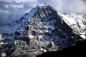
Eiger north face
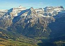
The Diablerets from the Pic Chaussy
Some notable summits of the range are:
| Name | elevation (m) | Alpine subsection |
|---|---|---|
| Finsteraarhorn | 4,274 | Bernese Alps s.s. |
| Aletschhorn | 4,193 | Bernese Alps s.s. |
| Jungfrau | 4,158 | Bernese Alps s.s. |
| Mönch | 4,105 | Bernese Alps s.s. |
| Schreckhorn | 4,080 | Bernese Alps s.s. |
| Fiescherhorn | 4,049 | Bernese Alps s.s. |
| Grünhorn | 4,043 | Bernese Alps s.s. |
| Lauteraarhorn | 4,042 | Bernese Alps s.s. |
| Gletscherhorn | 3,983 | Bernese Alps s.s. |
| Eiger | 3,970 | Bernese Alps s.s. |
| Äbeni Flue | 3,962 | Bernese Alps s.s. |
| Fiescher Gabelhorn | 3,876 | Bernese Alps s.s. |
| Doldenhorn | 3,643 | Bernese Alps s.s. |
| Dammastock | 3,630 | Urner Alps |
| Galenstock | 3,583 | Urner Alps |
| Sustenhorn | 3,503 | Urner Alps |
| Titlis | 3,238 | Urner Alps |
| Les Diablerets | 3,210 | Vaud Alps |
| Grand Muveran | 3,051 | Vaud Alps |
| Lohner | 3,048 | Bernese Alps s.s. |
| Wendenstöcke | 3,042 | Urner Alps |
| Sparrhorn | 3,021 | Bernese Alps s.s. |
| Torrenthorn | 2,998 | Bernese Alps s.s. |
| Dent de Morcles | 2,980 | Vaud Alps |
| Eggishorn | 2,934 | Bernese Alps s.s. |
Notable passes

Furka pass west side
Some notable mountain passes of the range are:
| Mountain pass | location | type | elevation | |
|---|---|---|---|---|
| Furka Pass | Rhône Glacier to Andermatt | road | 2436 m | 7992 ft |
| Gemmi Pass | Kandersteg to Leukerbad | bridle path | 2329 m | 7641 ft |
| Mönchjoch | Grindelwald to the Eggishorn | snow | 3560 m | 11,680 ft |
| Jungfraujoch | Wengernalp to the Eggishorn | snow | 3470 m | 11,385 ft |
| Grünhornlücke | Great Aletsch Glacier to the Fiescher Glacier | snow | 3305 m | 10,844 ft |
| Grimsel Pass | Meiringen to the Rhone Glacier | road | 2164 m | 7100 ft |
| Kleine Scheidegg | Grindelwald to Lauterbrunnen | path, railway | 2064 m | 6772 ft |
| Col de Cheville | Sion to Bex | bridle path | 2049 m | 6723 ft |
| Grosse Scheidegg | Grindelwald to Meiringen | bridle path | 1967 m | 6454 ft |
| Brünig Pass | Meiringen to Lucerne | road, railway | 1035 m | 3396 ft |
| Petersgrat | Lauterbrunnen to the Lötschental | snow | 3205 m | 10,516 ft |
| Lötschenlücke | Lötschental to the Eggishorn | snow | 3204 m | 10,512 ft |
| Susten Pass | Meiringen to Wassen | road | 2262 m | 7422 ft |
| Sanetsch Pass | Sion to Saanen | bridle path | 2234 m | 7331 ft |
References
- ↑ I.w.S. = in weitesten Sinne - in English: in the wide meaning
- ↑ d.l.s.l. = dans le sens large - in English: in the wide sense
- ↑ Marazzi, Sergio (2005). Atlante Orografico delle Alpi. SOIUSA (in Italian). Priuli & Verlucca. p. 145. ISBN 978-88-8068-273-8.
- ↑ s.s. = stricto sensu
- ↑ I.e.S. = in eigentlichen Sinne - in English: in the narrow meaning
Maps
- Swiss official cartography (Swiss Federal Office of Topography - Swisstopo); on-line version: map.geo.admin.ch
| Western Alps |
| ||||||||||
|---|---|---|---|---|---|---|---|---|---|---|---|
| Eastern Alps |
| ||||||||||
This article is issued from Wikipedia - version of the 2/24/2016. The text is available under the Creative Commons Attribution/Share Alike but additional terms may apply for the media files.