Surf City, New Jersey
| Surf City, New Jersey | |
|---|---|
| Borough | |
| Borough of Surf City | |
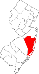
 Map of Surf City in Ocean County. Inset: Location of Ocean County highlighted in the State of New Jersey. | |
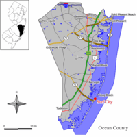
 Census Bureau map of Surf City, New Jersey | |
| Coordinates: 39°39′44″N 74°10′10″W / 39.662085°N 74.169456°WCoordinates: 39°39′44″N 74°10′10″W / 39.662085°N 74.169456°W[1][2] | |
| Country |
|
| State |
|
| County | Ocean |
| Incorporated | September 19, 1894 as Long Beach City |
| Renamed | May 26, 1899 as Surf City |
| Government[3] | |
| • Type | Borough |
| • Body | Borough Council |
| • Mayor | Francis R. Hodgson, Sr. (R, term ends December 31, 2019)[4][5] |
| • Administrator / Clerk | Mary P. Madonna[4] |
| Area[1] | |
| • Total | 0.917 sq mi (2.376 km2) |
| • Land | 0.745 sq mi (1.931 km2) |
| • Water | 0.172 sq mi (0.446 km2) 18.76% |
| Area rank |
510th of 566 in state 25th of 33 in county[1] |
| Elevation[6] | 3 ft (0.9 m) |
| Population (2010 Census)[7][8][9][10] | |
| • Total | 1,205 |
| • Estimate (2015)[11] | 1,204 |
| • Rank |
526th of 566 in state 27th of 33 in county[12] |
| • Density | 1,616.5/sq mi (624.1/km2) |
| • Density rank |
323rd of 566 in state 17th of 33 in county[12] |
| Time zone | Eastern (EST) (UTC-5) |
| • Summer (DST) | Eastern (EDT) (UTC-4) |
| ZIP code | 08008 - Beach Haven[13][14][15] |
| Area code(s) | 609[16] |
| FIPS code | 3402971640[1][17][18] |
| GNIS feature ID | 0885413[1][19] |
| Website |
www |
Surf City is a borough in Ocean County, New Jersey, United States. As of the 2010 United States Census, the borough's population was 1,205,[8][9][10] reflecting a decline of 237 (-16.4%) from the 1,442 counted in the 2000 Census, which had in turn increased by 67 (+4.9%) from the 1,375 counted in the 1990 Census.[20] The borough borders the Atlantic Ocean on Long Beach Island.
What is now Surf City was originally formed as Long Beach City borough by an act of the New Jersey Legislature on September 19, 1894, from portions of Stafford Township, based on the results of a referendum held the previous day. The borough was renamed Surf City by a resolution of the Borough Council as of May 26, 1899.[21] The name was changed to avoid confusion with other places on the island and along the Jersey Shore.[22][23]
History
Present-day Surf City was home to the first big boarding hotel on the Jersey Shore, called the Mansion of Health. The area surrounding this hotel was called "Buzby's Place" in the 1830s and 1840s, after one of the owners of the Mansion of Health, Hudson Buzby. The Mansion of Health burned down in 1874, but some old-timers still call the cove at the foot of South First Street on the bay side "Mansion Cove."[24]
In 1875, the 20 or so permanent residents of the area decided to call the area Long Beach City, even though the area was still considered part of Stafford Township. In 1894, Surf City was incorporated, changing its name to Surf City in 1899 after the United States Postal Service demanded a name change before the town could incorporate, preventing it from being confused with Long Branch in Monmouth County.[25][26]
Geography
According to the United States Census Bureau, the borough had a total area of 0.917 square miles (2.376 km2), including 0.745 square miles (1.931 km2) of land and 0.172 square miles (0.446 km2) of water (18.76%).[1][2]
The borough is located 57 miles (92 km) east-southeast of Philadelphia and 71 miles (114 km) south of New York City.
The borough borders the Ocean County municipalities of Long Beach Township, Ship Bottom and Stafford Township.[27]
Demographics
| Historical population | |||
|---|---|---|---|
| Census | Pop. | %± | |
| 1900 | 9 | — | |
| 1910 | 40 | 344.4% | |
| 1920 | 43 | 7.5% | |
| 1930 | 76 | 76.7% | |
| 1940 | 129 | 69.7% | |
| 1950 | 291 | 125.6% | |
| 1960 | 419 | 44.0% | |
| 1970 | 1,129 | 169.5% | |
| 1980 | 1,571 | 39.1% | |
| 1990 | 1,375 | −12.5% | |
| 2000 | 1,442 | 4.9% | |
| 2010 | 1,205 | −16.4% | |
| Est. 2015 | 1,204 | [11][28] | −0.1% |
| Population sources: 1900-2000[29] 1900-1920[30] 1900-1910[31] 1910-1930[32] 1930-1990[33] 2000[34][35] 2010[7][8][9][10] | |||
Census 2010
At the 2010 United States Census, there were 1,205 people, 622 households, and 365.7 families residing in the borough. The population density was 1,616.5 per square mile (624.1/km2). There were 2,566 housing units at an average density of 3,442.4 per square mile (1,329.1/km2). The racial makeup of the borough was 95.52% (1,151) White, 1.33% (16) Black or African American, 0.00% (0) Native American, 0.58% (7) Asian, 0.33% (4) Pacific Islander, 1.41% (17) from other races, and 0.83% (10) from two or more races. Hispanics or Latinos of any race were 5.06% (61) of the population.[8]
There were 622 households, of which 10.5% had children under the age of 18 living with them, 48.6% were married couples living together, 5.9% had a female householder with no husband present, and 41.2% were non-families. 35.9% of all households were made up of individuals, and 22.7% had someone living alone who was 65 years of age or older. The average household size was 1.94 and the average family size was 2.45.[8]
In the borough, 9.4% of the population were under the age of 18, 4.5% from 18 to 24, 14.6% from 25 to 44, 32.9% from 45 to 64, and 38.6% who were 65 years of age or older. The median age was 59.4 years. For every 100 females there were 95.6 males. For every 100 females age 18 and over, there were 96.4 males.[8]
The Census Bureau's 2006-2010 American Community Survey showed that (in 2010 inflation-adjusted dollars) median household income was $63,375 (with a margin of error of +/- $12,908) and the median family income was $74,479 (+/- $16,901). Males had a median income of $58,750 (+/- $18,197) versus $51,000 (+/- $27,120) for females. The per capita income for the borough was $42,677 (+/- $4,230). About 2.9% of families and 5.0% of the population were below the poverty line, including 11.7% of those under age 18 and 4.8% of those age 65 or over.[36]
Census 2000
As of the 2000 United States Census[17] there were 1,442 people, 706 households, and 420 families residing in the borough. The population density was 1,990.4 people per square mile (773.3/km²). There were 2,621 housing units at an average density of 3,617.9 per square mile (1,405.5/km²). The racial makeup of the borough was 98.06% White, 0.14% African American, 0.21% Native American, 0.35% Asian, 0.42% Pacific Islander, 0.55% from other races, and 0.28% from two or more races. Hispanic or Latino of any race were 1.94% of the population.[34][35]
There were 706 households out of which 13.0% had children under the age of 18 living with them, 48.6% were married couples living together, 7.1% had a female householder with no husband present, and 40.4% were non-families. 34.8% of all households were made up of individuals and 19.4% had someone living alone who was 65 years of age or older. The average household size was 2.04 and the average family size was 2.61.[34][35]
In the borough the population was spread out with 12.4% under the age of 18, 5.1% from 18 to 24, 21.6% from 25 to 44, 26.8% from 45 to 64, and 34.1% who were 65 years of age or older. The median age was 53 years. For every 100 females there were 90.5 males. For every 100 females age 18 and over, there were 88.8 males.[34][35]
The median income for a household in the borough was $38,190, and the median income for a family was $50,268. Males had a median income of $40,625 versus $25,208 for females. The per capita income for the borough was $26,632. About 5.6% of families and 7.5% of the population were below the poverty line, including 22.1% of those under age 18 and 3.9% of those age 65 or over.[34][35]
Sports
The Surf City Yacht Club participates in weekly races against other yacht clubs throughout the Island, with many sailors and swimmers ranging in age dedicating their summers to the Yacht Club.[37]
The Surf City Beach Patrol won the Surf City Epic, Lavallette, Ortley Beach, Island Beach State Park, the Midway Beach, and "Islands" Tournaments in 2008, narrowly missing out on victories at Sandy Hook (2nd) and the Ship Bottom (2nd) "State Tournament" losing by only a combined 4.5 points. The SCBP squad were back-to-back LBIBPA Island Champions (2007 & 2008) for the first time in the last 25+ years. The high point of the season came during the IBSP tournament when Surf City won by 23 points.[38]
Government
Local government
Surf City is governed under the Borough form of New Jersey municipal government. The governing body consists of a Mayor and a Borough Council comprising six council members, with all positions elected at-large on a partisan basis as part of the November general election. A Mayor is elected directly by the voters to a four-year term of office. The Borough Council consists of six members elected to serve three-year terms on a staggered basis, with two seats coming up for election each year in a three-year cycle.[3] The Borough form of government used by Surf City, the most common system used in the state, is a "weak mayor / strong council" government in which council members act as the legislative body with the mayor presiding at meetings and voting only in the event of a tie. The mayor can veto ordinances subject to an override by a two-thirds majority vote of the council. The mayor makes committee and liaison assignments for council members, and most appointments are made by the mayor with the advice and consent of the council.[39][40]
As of 2016, the Mayor of Surf City Borough is Republican Francis R. Hodgson, Sr., whose term of office ends December 31, 2019. After serving 46 years on the Borough Concil, Hodgson succeeded Leonard T. Connors, Jr., who had served as the state senator from the 9th Legislative District and 50 years as mayor. Members of the Surf City Borough Council are Council President Council President John H. Klose (R, 2018), John G. Hadash, III (R, 2017; appointed to serve an unexpired term), Peter M. Hartney, Jr. (R, 2016), William D. Hodgson (R, 2017), James B. Russell (R, 2018) and Jacqueline L. "Jackie" Siciliano (R, 2016).[4][41][42][43][44][45][46]
John G. Hadash, III was appointed to fill the seat expiring in December 2017 that had been held by Francis R. Hodgson, Sr., until he stepped down in January 2016 to take office as mayor; Hadash will serve on an interim basis until the November 2016 general election, when voters will select a candidate to serve the balance of the term of office.
Federal, state and county representation
Surf City is located in the 2nd Congressional District[47] and is part of New Jersey's 9th state legislative district.[9][48][49] Prior to the 2010 Census, Surf City had been part of the 3rd Congressional District, a change made by the New Jersey Redistricting Commission that took effect in January 2013, based on the results of the November 2012 general elections.[50]
New Jersey's Second Congressional District is represented by Frank LoBiondo (R, Ventnor City).[51] New Jersey is represented in the United States Senate by Cory Booker (D, Newark, term ends 2021)[52] and Bob Menendez (D, Paramus, 2019).[53][54]
For the 2016–2017 session (Senate, General Assembly), the 9th Legislative District of the New Jersey Legislature is represented in the State Senate by Christopher J. Connors (R, Lacey Township) and in the General Assembly by DiAnne Gove (R, Long Beach Township) and Brian E. Rumpf (R, Little Egg Harbor Township).[55] The Governor of New Jersey is Chris Christie (R, Mendham Township).[56] The Lieutenant Governor of New Jersey is Kim Guadagno (R, Monmouth Beach).[57]
Ocean County is governed by a Board of Chosen Freeholders consisting of five members, elected on an at-large basis in partisan elections and serving staggered three-year terms of office, with either one or two seats coming up for election each year as part of the November general election.[58] At an annual reorganization held in the beginning of January, the board chooses a Director and a Deputy Director from among its members. As of 2015, Ocean County's Freeholders (with party affiliation, term-end year, residence and department directorship listed in parentheses) are Freeholder Director John C. Bartlett, Jr. (R, term ends December 31, 2015, Pine Beach; Finance, Parks and Recreation),[59] Freeholder Deputy Director Gerry P. Little (R, 2015, Surf City; Human Services),[60] John P. Kelly (R, 2016, Eagleswood Township; Law and Public Safety),[61] James F. Lacey (R, 2016, Brick Township; Transportation)[62] and Joseph H. Vicari (R, 2017, Toms River; Senior Services and County Operations).[63][64][65] Constitutional officers elected on a countywide basis are County Clerk Scott M. Colabella (R, 2015, Barnegat Light),[66][67] Sheriff Michael Mastronardy (R, 2016; Toms River)[68] and Surrogate Jeffrey Moran (R, 2018, Beachwood).[69][70]
Politics
As of March 23, 2011, there were a total of 1,030 registered voters in Surf City, of which 166 (16.1%) were registered as Democrats, 433 (42.0%) were registered as Republicans and 427 (41.5%) were registered as Unaffiliated. There were 4 voters registered to other parties.[71] Among the borough's 2010 Census population, 85.5% (vs. 63.2% in Ocean County) were registered to vote, including 94.3% of those ages 18 and over (vs. 82.6% countywide).[71][72]
In the 2012 presidential election, Republican Mitt Romney received 61.8% of the vote (402 cast), ahead of Democrat Barack Obama with 37.8% (246 votes), and other candidates with 0.3% (2 votes), among the 655 ballots cast by the city's 1,108 registered voters (5 ballots were spoiled), for a turnout of 59.1%.[73][74] In the 2008 presidential election, Republican John McCain received 60.9% of the vote (485 cast), ahead of Democrat Barack Obama with 37.5% (299 votes) and other candidates with 1.0% (8 votes), among the 797 ballots cast by the borough's 1,078 registered voters, for a turnout of 73.9%.[75] In the 2004 presidential election, Republican George W. Bush received 60.8% of the vote (511 ballots cast), outpolling Democrat John Kerry with 38.0% (320 votes) and other candidates with 0.4% (5 votes), among the 841 ballots cast by the borough's 1,153 registered voters, for a turnout percentage of 72.9.[76]
In the 2013 gubernatorial election, Republican Chris Christie received 82.8% of the vote (448 cast), ahead of Democrat Barbara Buono with 15.9% (86 votes), and other candidates with 1.3% (7 votes), among the 559 ballots cast by the city's 1,070 registered voters (18 ballots were spoiled), for a turnout of 52.2%.[77][78] In the 2009 gubernatorial election, Republican Chris Christie received 61.2% of the vote (417 ballots cast), ahead of Democrat Jon Corzine with 31.0% (211 votes), Independent Chris Daggett with 5.9% (40 votes) and other candidates with 0.3% (2 votes), among the 681 ballots cast by the borough's 1,043 registered voters, yielding a 65.3% turnout.[79]
Education
For Kindergarten through sixth grade, public school students attend the Long Beach Island Consolidated School District, which also serves students from Barnegat Light, Harvey Cedars, Long Beach Township and Ship Bottom.[3][80] As of the 2011-12 school year, the district's two schools had an enrollment of 238 students and 26.9 classroom teachers (on an FTE basis), for a student–teacher ratio of 8.85:1.[81] Schools in the district (with 2011-12 enrollment data from the National Center for Education Statistics[82]) are Ethel Jacobsen School[83] in Surf City with 138 students in grades Kindergarten – 2 and Long Beach Island Grade School[84] in Ship Bottom with 100 students in grades 3 – 6.[85]
Students in public school for seventh through twelfth grades attend the Southern Regional School District, which serves the five municipalities in the Long Beach Island Consolidated School District, along with students from Beach Haven and Stafford Township, as well as students from Ocean Township (including its Waretown section) who attend as part of a sending/receiving relationship.[3][86] Schools in the district (with 2013-14 enrollment data from the National Center for Education Statistics[87]) are Southern Regional Middle School[88] (grades 7 and 8; 992 students) and Southern Regional High School[89] (grades 9 – 12; 2,071 students).[90] Both schools are in the Manahawkin section of Stafford Township.
Transportation
Roads and highways
As of May 2010, the borough had a total of 16.97 miles (27.31 km) of roadways, of which 15.30 miles (24.62 km) were maintained by the municipality and 1.67 miles (2.69 km) by Ocean County.[91]
Public transportation
TransportAzumah offers weekend service during the summer season between Midtown Manhattan in New York City and Long Beach Island with a stop at Newark Liberty International Airport.[92]
Ocean Ride local service is provided on the OC9 Long Beach Island route.[93][94][95]
The LBI Shuttle operates along Long Beach Boulevard, providing free service every 5 to 20 minutes from 10:00 AM to 10:00 PM. It serves the Long Beach Island municipalities / communities of Barnegat Light, Loveladies, Harvey Cedars, North Beach, Surf City, Ship Bottom, Long Beach Township, Beach Haven and Holgate.[96]
Media
Surf City is served primarily by Philadelphia and New York television stations, Atlantic City and Philadelphia-based radio stations and two daily newspapers, The Press of Atlantic City and Asbury Park Press.
Notable people
People who were born in, residents of, or otherwise closely associated with Surf City include:
- Leonard T. Connors (born 1929), politician who served in the New Jersey State Senate from 1982 to 2008, where he represented the 9th Legislative District, and served for 50 years as mayor of Surf City, from 1966 to 2016.[97]
- Gerry P. Little, served on the Ocean County Board of Chosen Freeholders since 2003, and was elected to the Surf City Borough Council in 1995, where he served for eight years.[98]
References
- 1 2 3 4 5 6 2010 Census Gazetteer Files: New Jersey County Subdivisions, United States Census Bureau. Accessed May 21, 2015.
- 1 2 US Gazetteer files: 2010, 2000, and 1990, United States Census Bureau. Accessed September 4, 2014.
- 1 2 3 4 2012 New Jersey Legislative District Data Book, Rutgers University Edward J. Bloustein School of Planning and Public Policy, March 2013, p. 49.
- 1 2 3 Home Page, Borough of Surf City. Accessed July 27, 2016.
- ↑ 2016 New Jersey Mayors Directory, New Jersey Department of Community Affairs. Accessed June 14, 2016.
- ↑ U.S. Geological Survey Geographic Names Information System: Borough of Surf City, Geographic Names Information System. Accessed March 14, 2013.
- 1 2 "DataUniverse - 2010 Census Populations: Ocean County", Asbury Park Press. Accessed January 2, 2013.
- 1 2 3 4 5 6 DP-1 - Profile of General Population and Housing Characteristics: 2010 for Surf City borough, Ocean County, New Jersey, United States Census Bureau. Accessed January 2, 2013.
- 1 2 3 4 Municipalities Grouped by 2011-2020 Legislative Districts, New Jersey Department of State, p. 5. Accessed January 6, 2013.
- 1 2 3 Profile of General Demographic Characteristics: 2010 for Surf City borough, New Jersey Department of Labor and Workforce Development. Accessed January 2, 2013.
- 1 2 PEPANNRES - Annual Estimates of the Resident Population: April 1, 2010 to July 1, 2015 - 2015 Population Estimates for New Jersey municipalities, United States Census Bureau. Accessed May 22, 2016.
- 1 2 GCT-PH1 Population, Housing Units, Area, and Density: 2010 - State -- County Subdivision from the 2010 Census Summary File 1 for New Jersey, United States Census Bureau. Accessed January 2, 2013.
- ↑ Look Up a ZIP Code for Surf City, NJ, United States Postal Service. Accessed January 2, 2013.
- ↑ Look Up a ZIP Code for 08008, United States Postal Service. Accessed January 2, 2013.
- ↑ Zip Codes, State of New Jersey. Accessed August 30, 2013.
- ↑ Area Code Lookup - NPA NXX for Surf City, NJ, Area-Codes.com. Accessed August 30, 2013.
- 1 2 American FactFinder, United States Census Bureau. Accessed September 4, 2014.
- ↑ A Cure for the Common Codes: New Jersey, Missouri Census Data Center. Accessed October 31, 2012.
- ↑ US Board on Geographic Names, United States Geological Survey. Accessed September 4, 2014.
- ↑ Table 7. Population for the Counties and Municipalities in New Jersey: 1990, 2000 and 2010, New Jersey Department of Labor and Workforce Development, February 2011. Accessed January 2, 2013.
- ↑ Snyder, John P. The Story of New Jersey's Civil Boundaries: 1606-1968, Bureau of Geology and Topography; Trenton, New Jersey; 1969. p. 205. Accessed October 25, 2012.
- ↑ Borough of Surf City History, LBI.net. Accessed October 11, 2015. "The residents of the Great Swamp area (now sometimes referred to as Old Mansion) wanted their community to acquire the same prestige and popularity, so in 1875, they elected to call their town Long Beach City. However, the name lasted for only nineteen years because it was too similar to other area names such as Long Beach, Long Branch and Long Island. The name Surf City was selected and has been used since 1894."
- ↑ Somerville, George B. The Lure of Long Beach, p. 52. Long Beach Board of Trade, 1914. Accessed October 11, 2015. "Next down the beach from Harvey Cedars is Surf City. The original name of this resort, founded in 1873, was Long Beach City, but the similarity of the name with that of Long Branch caused much confusion in mails, freights and express, and the name was changed to Surf City."
- ↑ Lloyd, pgs. 31-33.
- ↑ Lloyd, pg. 32.
- ↑ Africano, Lilian; and Africano, Nina. Jersey Shore, p. 12. Globe Pequot Press, 2004. ISBN 9780762730032. Accessed September 24, 2013.
- ↑ Areas touching Surf City, MapIt. Accessed August 12, 2015.
- ↑ Census Estimates for New Jersey April 1, 2010 to July 1, 2015, United States Census Bureau. Accessed May 22, 2016.
- ↑ Barnett, Bob. Population Data for Ocean County Municipalities, 1850 - 2000, WestJersey.org, January 6, 2011. Accessed January 2, 2013.
- ↑ Compendium of censuses 1726-1905: together with the tabulated returns of 1905, New Jersey Department of State, 1906. Accessed August 30, 2013.
- ↑ Thirteenth Census of the United States, 1910: Population by Counties and Minor Civil Divisions, 1910, 1900, 1890, United States Census Bureau, p. 338. Accessed January 2, 2013.
- ↑ Fifteenth Census of the United States : 1930 - Population Volume I, United States Census Bureau, p. 718. Accessed January 2, 2013.
- ↑ Table 6. New Jersey Resident Population by Municipality: 1930 - 1990, New Jersey Department of Labor and Workforce Development. Accessed June 28, 2015.
- 1 2 3 4 5 Census 2000 Profiles of Demographic / Social / Economic / Housing Characteristics for Surf City borough, New Jersey, United States Census Bureau. Accessed January 2, 2013.
- 1 2 3 4 5 DP-1: Profile of General Demographic Characteristics: 2000 - Census 2000 Summary File 1 (SF 1) 100-Percent Data for Surf City borough, Ocean County, New Jersey, United States Census Bureau. Accessed January 2, 2013.
- ↑ DP03: Selected Economic Characteristics from the 2006-2010 American Community Survey 5-Year Estimates for Surf City borough, Ocean County, New Jersey, United States Census Bureau. Accessed January 2, 2013.
- ↑ Home page, Surf City Yacht Club. Accessed January 2, 2013.
- ↑ Home page, Surf City Beach Patrol. Accessed January 2, 2013.
- ↑ Cerra, Michael F. "Forms of Government: Everything You've Always Wanted to Know, But Were Afraid to Ask", New Jersey State League of Municipalities. Accessed November 30, 2014.
- ↑ "Forms of Municipal Government in New Jersey", p. 6. Rutgers University Center for Government Studies. Accessed June 3, 2015.
- ↑ 2016 Municipal User Friendly Budget, Borough of Surf City. Accessed July 27, 2016.
- ↑ 2016 Ocean County & Municipal Elected Officials, Ocean County, New Jersey Clerk, updated February 22, 2016. Accessed July 26, 2016.
- ↑ Borough of Surf City, Ocean County, New Jersey. Accessed July 26, 2016.
- ↑ 2015 General Election Official Results November 3, 2015, Ocean County, New Jersey Clerk, updated November 10, 2015. Accessed July 26, 2016.
- ↑ General Election November 4, 2014, Ocean County, New Jersey Clerk, updated November 12, 2014. Accessed July 26, 2016.
- ↑ General Election November 5, 2013, Ocean County, New Jersey Clerk, updated November 14, 2013. Accessed July 26, 2016.
- ↑ Plan Components Report, New Jersey Redistricting Commission, December 23, 2011. Accessed January 6, 2013.
- ↑ 2016 New Jersey Citizen's Guide to Government, p. 64, New Jersey League of Women Voters. Accessed July 20, 2016.
- ↑ Districts by Number for 2011-2020, New Jersey Legislature. Accessed January 6, 2013.
- ↑ 2011 New Jersey Citizen's Guide to Government, p. 65, New Jersey League of Women Voters. Accessed May 22, 2015.
- ↑ Directory of Representatives: New Jersey, United States House of Representatives. Accessed January 5, 2012.
- ↑ About Cory Booker, United States Senate. Accessed January 26, 2015. "He now owns a home and lives in Newark's Central Ward community."
- ↑ Biography of Bob Menendez, United States Senate, January 26, 2015. "He currently lives in Paramus and has two children, Alicia and Robert."
- ↑ Senators of the 114th Congress from New Jersey. United States Senate. Accessed January 26, 2015. "Booker, Cory A. - (D - NJ) Class II; Menendez, Robert - (D - NJ) Class I"
- ↑ Legislative Roster 2016-2017 Session, New Jersey Legislature. Accessed January 17, 2016.
- ↑ "About the Governor". State of New Jersey. Retrieved 2010-01-21.
- ↑ "About the Lieutenant Governor". State of New Jersey. Retrieved 2010-01-21.
- ↑ Freeholder History, Ocean County, New Jersey. Accessed January 25, 2015.
- ↑ Freeholder Director John C. Bartlett Jr., Ocean County, New Jersey. Accessed January 25, 2015.
- ↑ Freeholder Deputy Director Gerry P. Little, Ocean County, New Jersey. Accessed January 25, 2015.
- ↑ Freeholder John P. Kelly, Ocean County, New Jersey. Accessed January 25, 2015.
- ↑ Freeholder James F. Lacey, Ocean County, New Jersey. Accessed January 25, 2015.
- ↑ Freeholder Joseph H. Vicari, Ocean County, New Jersey. Accessed January 25, 2015.
- ↑ Board of Chosen Freeholders, Ocean County, New Jersey. Accessed January 25, 2015.
- ↑ County Directory, Ocean County, New Jersey. Accessed January 25, 2015.
- ↑ County Clerk, Ocean County, New Jersey. Accessed January 25, 2015.
- ↑ Biography of Scott M. Colabella, Office of the County Clerk. Accessed January 25, 2015.
- ↑ Sheriff Michael Mastronardy, Ocean County Sheriff's Office. Accessed January 25, 2015.
- ↑ County Surrogate Jeffrey W. Moran, Ocean County, New Jersey. Accessed January 25, 2015.
- ↑ 2015 Elected Officials of Ocean County, Ocean County, New Jersey. Accessed January 25, 2015.
- 1 2 Voter Registration Summary - Ocean, New Jersey Department of State Division of Elections, March 23, 2011. Accessed January 2, 2013.
- ↑ GCT-P7: Selected Age Groups: 2010 - State -- County Subdivision; 2010 Census Summary File 1 for New Jersey, United States Census Bureau. Accessed January 2, 2013.
- ↑ "Presidential General Election Results - November 6, 2012 - Ocean County" (PDF). New Jersey Department of Elections. March 15, 2013. Retrieved December 24, 2014.
- ↑ "Number of Registered Voters and Ballots Cast - November 6, 2012 - General Election Results - Ocean County" (PDF). New Jersey Department of Elections. March 15, 2013. Retrieved December 24, 2014.
- ↑ 2008 Presidential General Election Results: Ocean County, New Jersey Department of State Division of Elections, December 23, 2008. Accessed January 2, 2013.
- ↑ 2004 Presidential Election: Ocean County, New Jersey Department of State Division of Elections, December 13, 2004. Accessed January 2, 2013.
- ↑ "Governor - Ocean County" (PDF). New Jersey Department of Elections. January 29, 2014. Retrieved December 24, 2014.
- ↑ "Number of Registered Voters and Ballots Cast - November 5, 2013 - General Election Results - Ocean County" (PDF). New Jersey Department of Elections. January 29, 2014. Retrieved December 24, 2014.
- ↑ 2009 Governor: Ocean County, New Jersey Department of State Division of Elections, December 31, 2009. Accessed January 2, 2013.
- ↑ LAN Associates. Study of School Consolidation Long Beach Island, New Jersey, Long Beach Island Consolidated School District, January 21, 2011. Accessed September 25, 2013. "The Long Beach Island Consolidated School District serves the needs of the citizens of Long Beach Island including the communities of Barnegat Light Borough, Long Beach Township, Harvey Cedars Borough, Surf City Borough, and Ship Bottom Borough. The remaining community of Beach Haven at the south end of the island currently has its own school. The Long Beach Island Consolidated Schools serve children from the age of pre-school through sixth grade after which the students attend Southern Regional High School in Manahawkin."
- ↑ District information for Long Beach Island Consolidated School District, National Center for Education Statistics. Accessed September 9, 2014.
- ↑ School Data for the Long Beach Island School District, National Center for Education Statistics. Accessed September 9, 2014.
- ↑ Ethel Jacobsen School, Long Beach Island Consolidated School District. Accessed September 9, 2014.
- ↑ Long Beach Island Grade School, Long Beach Island Consolidated School District. Accessed September 9, 2014.
- ↑ New Jersey School Directory for the Long Beach Island Consolidated School District, New Jersey Department of Education. Accessed September 9, 2014.
- ↑ Southern Regional High School 2015 Report Card Narrative, New Jersey Department of Education. Accessed June 2, 2016. "Located in Manahawkin, the Southern Regional School District draws from the constituent districts of Long Beach Township, Beach Haven, Surf City, Ship Bottom, Barnegat Light, Harvey Cedars and Stafford Township, as well as the tuition sending district of Ocean Township (Waretown).
- ↑ School Data for the Southern Regional School District, National Center for Education Statistics. Accessed June 2, 2016.
- ↑ Southern Regional Middle School, Southern Regional School District. Accessed June 2, 2016.
- ↑ Southern Regional High School, Southern Regional School District. Accessed June 2, 2016.
- ↑ New Jersey School Directory for the Southern Regional School District, New Jersey Department of Education. Accessed June 2, 2016.
- ↑ Ocean County Mileage by Municipality and Jurisdiction, New Jersey Department of Transportation, May 2010. Accessed July 18, 2014.
- ↑ Route TAZ10, TransportAzumah. Accessed March 10, 2015.
- ↑ Ocean County Bus Service, Greater Mercer TMA. Accessed August 12, 2015.
- ↑ Ocean Ride Rider's Guide, Ocean County, New Jersey. Accessed August 12, 2015.
- ↑ Ocean County Transit Guide, Ocean County, New Jersey. Accessed August 12, 2015.
- ↑ LBI Shuttle, Borough of Barnegat Light. Accessed August 9, 2015.
- ↑ Senator Leonard T. Connors Jr. (R), New Jersey Legislature, backed up by the Internet Archive as of February 2, 2008. Accessed June 5, 2015.
- ↑ Freeholder Gerry P. Little, Ocean County, New Jersey. Accessed January 2, 2013.
Sources
- Lloyd, John Bailey. Eighteen Miles of History on Long Beach Island., Down The Shore Publishing and The SandPaper, Inc., 1994. ISBN 9780945582175.
External links
- Official web site
- Surf City Borough municipal information
- Surf City Beach Patrol Home Page
- Long Beach Island School District
- Long Beach Island School District's 2014–15 School Report Card from the New Jersey Department of Education
- School Data for the Long Beach Island School District, National Center for Education Statistics
- Southern Regional School District
- Long Beach Island Branch (Surf City) of Ocean County Library
| Preceded by North Beach |
Beaches of New Jersey | Succeeded by Ship Bottom |