Quintana Roo
| Quintana Roo | |||
|---|---|---|---|
| State | |||
| Estado Libre y Soberano de Quintana Roo | |||
| |||
| Anthem: Himno a Quintana Roo | |||
.svg.png) State of Quintana Roo within Mexico | |||
| Coordinates: 19°36′N 87°55′W / 19.6°N 87.92°WCoordinates: 19°36′N 87°55′W / 19.6°N 87.92°W | |||
| Country | Mexico | ||
| Capital | Chetumal | ||
| Largest City | Cancún | ||
| Municipalities | 11 | ||
| Admission | October 8, 1974[1] | ||
| Order | 30th | ||
| Government | |||
| • Governor |
Carlos Joaquín | ||
| • Parliament | Congress of Quintana Roo | ||
| • Senators[2] |
Pedro Joaquín Ludivina Menchaca José Luis García | ||
| • Deputies[3] | |||
| Area[4] | |||
| • Total | 44,705 km2 (17,261 sq mi) | ||
| Ranked 19th | |||
| Highest elevation[5] | 230 m (750 ft) | ||
| Population (2015)[6] | |||
| • Total | 1,501,562 | ||
| • Rank | 26th | ||
| • Density | 34/km2 (87/sq mi) | ||
| • Density rank | 24th | ||
| Demonym(s) | Quintanarroense | ||
| Time zone | EST (UTC−5) | ||
| Postal code | 77 | ||
| Area code | |||
| ISO 3166 code | MX-ROO | ||
| HDI |
| ||
| GDP | US$ 10,286,552.031 th[a] | ||
| Website |
www | ||
| ^ a. The state's GDP was $131,667,866 thousand of pesos in 2008,[5] amount corresponding to $10,286,552.031 thousand of dollars, being a dollar worth 12.80 pesos (value of June 3, 2010).[7] | |||


Quintana Roo (Spanish pronunciation: [kinˈtana ˈro]), officially the Free and Sovereign State of Quintana Roo (Spanish: Estado Libre y Soberano de Quintana Roo), is one of the 31 states which, with the Federal District, make up the 32 federal entities of Mexico. It is divided into ten municipalities and its capital city is Chetumal.
It is located in Southeastern Mexico, on the eastern part of the Yucatán Peninsula. It is bordered by the states of Campeche to the west and Yucatán to the northwest, and by the Orange Walk and Corozal districts of Belize, along with an offshore borderline with Belize District to the south. Quintana Roo has a coastline to the east with the Caribbean Sea and to the north with the Gulf of Mexico. It also claims territory which gives it a small border with Guatemala in the southwest of the state, although this disputed area is also claimed by Campeche.
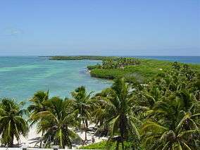
Quintana Roo is the home of the city of Cancún, the islands of Cozumel and Isla Mujeres, and the towns of Bacalar, Playa del Carmen and Akumal, as well as the ancient Maya ruins of Chacchoben, Cobá, Kohunlich, Muyil, Tulum, Xel-Há, and Xcaret. The Sian Ka'an biosphere reserve is also located in the state.
The state officially covers an area of 44,705 square kilometers (17,261 sq mi), but since 1997 there is a boundary dispute with the states of Yucatán and Campeche over an area of approximately 10,200 square kilometers (3,900 sq mi).[8][9]
The statewide population is expanding at a rapid rate due to the construction of hotels and the demand for workers. Many immigrants come from Yucatán, Campeche, Tabasco, and Veracruz. The state is frequently hit by severe hurricanes due to its exposed location, the most recent and severe being Hurricane Dean in 2007, which made landfall with sustained winds of 280 km/h (175 mph), with gusts up to 320 km/h (200 mph).
On February 1, 2015, Quintana Roo officially adopted a new time zone, Southeastern, which is five hours behind Coordinated Universal Time (UTC−05:00), and corresponds to Eastern Standard Time (EST).[10] Reasons cited for the change include coordination of air travel, banking operations, and more daylight hours, the latter of which will result in less energy usage.[10]
History

The area that makes up modern Quintana Roo was long part of Yucatán, sharing its history. With the Caste War of Yucatán, which started in the 1840s, all non-natives were driven from the region. The independent Maya nation of Chan Santa Cruz was based on what is now the town of Felipe Carrillo Puerto. For decades it maintained considerable independence, having separate trade and treaty relationships with British Honduras, now Belize.
Quintana Roo was made a territory of Mexico by decree of President Porfirio Díaz on November 24, 1902. It was named after an early patriot of the Mexican Republic, Andrés Quintana Roo. The Mexican army succeeded in defeating most of the Maya population of the region during the 1910s. In 1915 the area was again declared to be legally part of the state of Yucatán.
Quintana Roo was granted statehood within the United Mexican States on October 8, 1974.[1] It is the Mexican Republic's youngest state.
Climate
According to the Köppen climate classification, much of the state has a tropical wet and dry climate (Aw) while the island of Cozumel has a tropical monsoon climate (Am).[11] The mean annual temperature is 26 °C (78.8 °F).[12] The hottest months are April and August where the average high is 33 °C (91.4 °F) while January is coldest month with an average low of 17 °C (62.6 °F).[12] Extreme temperatures can range from low of 10 °C (50.0 °F) in the coldest months to 36 °C (96.8 °F) in the hottest months.[11] Quintana Roo averages 1,300 mm (51 in) of precipitation per year, which falls throughout the year, though June to October are the wetter months.[12] Hurricanes can occasionally hit the coastal areas during the hurricane season, particularly from September to November.[11]
Demographics
| Historical population | ||
|---|---|---|
| Year | Pop. | ±% |
| 1895[13] | — | |
| 1900 | — | |
| 1910 | 9,109 | — |
| 1921 | 10,966 | +20.4% |
| 1930 | 10,620 | −3.2% |
| 1940 | 18,752 | +76.6% |
| 1950 | 26,967 | +43.8% |
| 1960 | 50,169 | +86.0% |
| 1970 | 88,150 | +75.7% |
| 1980 | 225,985 | +156.4% |
| 1990 | 493,277 | +118.3% |
| 1995 | 703,536 | +42.6% |
| 2000 | 874,963 | +24.4% |
| 2005 | 1,135,309 | +29.8% |
| 2010 | 1,325,578 | +16.8% |
| 2015[14] | 1,501,562 | +13.3% |
Municipalities
The State of Quintana Roo is divided into 11 municipalities (Spanish: municipios), each headed by a municipal president:[15]
Tourism, ecotourism, and globalization
Tourism


Quintana Roo's tourist boom began in the 1970s.[16] Tourism resulted in the development of coastal hotels and resorts, in addition to ecotourism inland and in coastal regions, which have increased the development of the region as well as the gross domestic product.[17] Quintana Roo ranks sixth among Mexican states according to the United Nations Human Development index (HDI).[18]
Biotic situation of the Yucatán Peninsula
The Yucatán Peninsula is one of the most forested areas of the world in terms of biotic mass per hectare.[16] However, anthropological, biological and governmental experts have determined that Quintana Roo is 'facing a faunal crisis'.[16] Many medium to large game animals are disappearing due to hunting and habitat loss. While its population is relatively small, Quintana Roo is experiencing both a population influx and an increase in tourism.[16][18] This only increases the pressure on the plants and animals native to the area.
Ecosystems and animals
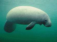
There are four generalized ecosystems in Quintana Roo—tropical forests, or jungle; savanna, mangrove forests, and coral reefs. One of the byproducts of traditional and large-scale agriculture is the creation of additional habitats, such as second growth forests and fields/pastures.[19] Tourism has caused Quintana Roo to become famous around the world in the last thirty or so years for its beaches, coastline and cenote sinkholes.[20] Biological experts consider the coastline of Quintana Roo one of the best manatee habitats worldwide.[21] Queen conchs are also noted for their inhabitation of coastal territory.[21] The wide variety of biotic organisms such as these has decreased drastically in the last fifteen years.[17][22]
Avifauna
Also affected by the loss of habitat due to both agriculture and development, birds are one of the region's most varied animal assets.[16] Hundreds of species reside in Quintana Roo permanently, with hundreds of others either wintering there or using it as a stopover on the long journey into South America.[21] As a result, many birders come to the area annually in search of the rare and unexpected.[16]
Effects of tourism
Many blame the environmental damage in Quintana Roo on either the regional government or outside investors.[17] However, resorts and hotels in Quintana Roo have created jobs and increased economic activity, which in turn has resulted in growth.[17][22]
Tourism projections and the native Maya
Projections for the tourism economy of Quintana Roo were exceedingly optimistic. It houses multiple tourist attractions from the Maya ruins to the lush forests and beautiful beaches. However, the long-term effects were not foreseen. The effect on the local environment was not properly considered. Economic stresses of development and population were virtually ignored.[22] The effect on the native population was not properly considered. The 'economic marginalization' of the Maya has had drastic effects on their sense of place and identity.[17]
Education
Universities
- Instituto Tecnológico de Cancún, Cancún
- Instituto Tecnológico de Chetumal, Chetumal
- University of Quintana Roo, Chetumal
- Intercultural Maya University of Quintana Roo, José María Morelos
- Universidad Anáhuac Cancún, Cancún
- Universidad del Caribe, Cancún
- Universidad Tecnológica de la Riviera Maya, Playa del Carmen
- Universidad La Salle Cancún, Cancún
Sports
The Atlante F.C. was founded in 1916 in Mexico City and they now play association football (soccer) in the Primera División de México. Their home ground (since 2007) is the Estadio Andrés Quintana Roo in Cancún.[23]
After playing the 1955–2001 seasons in Mexico City and the 2002–2005 seasons in Puebla the Quintana Roo Tigers have been playing baseball with a home field at the Estadio de Béisbol Beto Ávila in Cancún since the 2006 season.[24] The Tigers made it to the Mexican League series in 2009, but lost to the Saraperos de Saltillo 4 games to 2.[25]
Flora and fauna
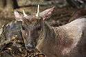
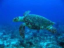
| Flora and fauna of Quintana Roo | |||||||
 |
 |
 |
_-_male.jpg) |
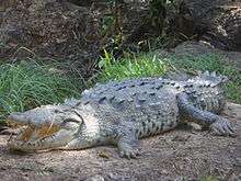 | |||
| Trichechus | Mazama Pandora | Eretmochelys imbricata | Crax rubra | Crocodylus acutus | |||
_(6766684927).jpg) |
 |
 |
 |
.jpg) | |||
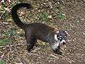
| Ateles geoffroyi | Sarcoramphus papa | Tamandua mexicana | Nasua | Boa constrictor | |||
 |
 |
 |
 |
 | |||
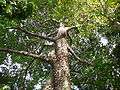
| Ceiba pentandra | Enterolobium cyclocarpum | Mangrove | Haematoxylum campechianum | Bixa orellana | |||
Time zone
On February 1, 2015, Quintana Roo officially adopted a new time zone, Southeastern, which is five hours behind Coordinated Universal Time (UTC−05:00). Quintana Roo does not observe daylight saving time, so Southeastern Time is constant throughout the year (that is, it does not shift forward in the spring and back in the fall). Southeastern Time (ST) is the same as Eastern Standard Time (EST) and Central Daylight Time (CDT). This means that in the winter, Quintana Roo has the same time as regions observing EST, such as the eastern U.S., eastern Canada, Cuba, and Jamaica; and in the summer, Quintana Roo has the same time as regions observing CDT, such as central Mexico.[10][26][27][28][29][30]
Quintana Roo changed to Southeastern Time for economic reasons, including:
- Allowing tourists in areas such as Cancun, Cozumel, and Playa del Carmen to spend more time and money at beaches, restaurants, historic sites, and other venues.
- Reducing electricity usage by hotels, restaurants, and other facilities.
Before Quintana Roo adopted the Southeastern time zone (officially referred to as zona sureste in Mexico), it had been part of the Central time zone (zona centro).
See also
Notes
- 1 2 "Poder Legislativo del Estado de Quintana Roo" (PDF) (in Spanish).
- ↑ "Senadores por Quintana Roo LXI Legislatura". Senado de la Republica. Retrieved April 5, 2011.
- ↑ "Listado de Diputados por Grupo Parlamentario del Estado de Quintana Roo". Camara de Diputados. Retrieved April 6, 2011.
- ↑ "Resumen". Cuentame INEGI. Retrieved February 12, 2013.
- 1 2 "Relieve". Cuentame INEGI. Retrieved April 6, 2011.
- ↑ "Encuesta Intercensal 2015" (PDF). Retrieved December 8, 2015.
- ↑ "Reporte: Jueves 3 de Junio del 2010. Cierre del peso mexicano.". www.pesomexicano.com.mx. Retrieved August 10, 2010.
- ↑ "Controversia Constitucional: Estado de Quintana Roo Vs. Estado de Yucatán (3 de Mayo de 1997)". Suprema Corte de Justicia de la Nacion. Retrieved April 6, 2011.
- ↑ "Campeche insiste en que Quintana Roo le invadió terreno". Notisureste. Retrieved April 6, 2011.
- 1 2 3 "Quintana Roo estrena horario mañana (Spanish)" (in Spanish). Retrieved February 1, 2015.
- 1 2 3 "MEDIO FÍSICO". Enciclopedia de Los Municipios y Delegaciones de México (in Spanish). Instituto para el Federalismo y el Desarrollo Municipal. Retrieved February 1, 2016.
- 1 2 3 "Clima". Información por entidad (in Spanish). Instituto Nacional de Estadística y Geografía. Retrieved February 1, 2016.
- ↑ "Mexico: extended population list". GeoHive. Archived from the original on March 11, 2012. Retrieved 2011-07-29.
- ↑ "Encuesta Intercensal 2015" (PDF). INEGI. Retrieved 2015-12-08.
- ↑ Hernández, Silvia (2 February 2011). "Bacalar, el décimo municipio de Q. Roo". El Universal. Retrieved 12 April 2011.
- 1 2 3 4 5 6 Anderson, E. N. and Felix Medina Tzuc. 2005. Animals and the Maya in Southeast Mexico. University of Arizona Press. Tucson, Arizona.
- 1 2 3 4 5 Daltabuit, Magali and Oriol Pi-Sunyer. 1990. Tourism Development in Quintana Roo, Mexico. Cultural Survival Quarterly 14.2, 9-13.
- 1 2 Encyclopædia Britannica 2008. "Quintana Roo". Encyclopædia Britannica Online. http://www.britannica.com/eb/article-9062295. Retrieved February 21, 2008.
- ↑ Villa Rojas, Alfonso. 1945. The Maya of East Central Quintana Roo. Carnegie Institute of Washington Publication 559. Washington D.C.
- ↑ "Adventure on the Ruta de los Cenotes". Travel Addicts. Retrieved 6 November 2016.
- 1 2 3 Schlesinger, Victoria. 2001. Animals and Plants of the Ancient Maya: A Guide. University of Texas Press. Austin, Texas.
- 1 2 3 Juarez, Ana M. 2002. "Ecological Degradation, Global Tourism, and Inequality: Maya Interpretations of the Changing Environment in Quintana Roo, Mexico. Human Organization 61.2, 113-124.
- ↑ ":: Atlante Futbol Club ::". Retrieved 15 April 2011.
- ↑ ":.TIGRES DE QUINTANAROO.". Retrieved 15 April 2011.
- ↑ "2009 Playoffs - MiLB.com Events - The Official Site of Minor League Baseball". Retrieved 15 April 2011.
- ↑ "Mexico's Quintana Roo Gears Up for Feb. 1 Time Change". TravelPulse. Retrieved 10 February 2015.
- ↑ Haynes, Danielle (29 January 2015). "Cancun switches to Eastern time zone". UPI. Retrieved 10 February 2015.
- ↑ "Cancun Region Gets Longer Evenings". Time and Date. 14 January 2015. Retrieved 10 February 2015.
- ↑ "Boletín 266 .- Celebra SECTUR reforma a ley del sistema de horario en los Estados Unidos Mexicanos". Mexican Ministry of Tourism (in Spanish). Retrieved 8 March 2015.
- ↑ "DECRETO por el que se reforman los artículos 2 y 3 de la Ley del Sistema de Horario en los Estados Unidos Mexicanos". Official Journal of the Federation (in Spanish). Mexican Interior Ministry. Retrieved 8 March 2015.
References
- Dumond, Don E.1985 The Talking Crosses of Yucatán: A New Look at their History. Ethnohistory 32(4):291–308.
- Freidel, David., Schele, Linda., et al. 1993 Maya Cosmos: Three thousand years on the Shaman's Path. New York: W. Morrow
- Harrison, Peter D. 1985 Some Aspects of Preconquest Settlement in Southern Quintana Roo, Mexico. Lowland Maya Settlement Patterns edited by Wendy Ashmore Albuquerque: University of New Mexico Press, A School of American Research Book.
- Villa Rojas, Alfonso. 1945 The Maya of East Central Quintana Roo: The Pagan-Christian Religious Complex. Washington, D.C.: Carnegie Institution.
Further reading
- Anderson, E. N. and Felix Medina Tzuc. Animals and the Maya in Southeast Mexico. University of Arizona Press. Tucson, Arizona. 2005.
- Brannon, Jeffery T. and Gilbert M. Joseph. Eds. 1991 Land, labor & capital in modern Yucatán: essays in regional history and political economy. Tuscaloosa: University of Alabama Press.
- Barton Bray, David, Marcelo Carreon, Leticia Merino, and Victoria Santos. "On the Road to Sustainable Forestry: The Maya of Quintana Roo are Striving to Combine Economic Efficiency, Ecological Sustainability, and a Democratic Society." Cultural Survival Quarterly 17.1, 38-41. 1993.
- Daltabuit, Magali and Oriol Pi-Sunyer. 1990. Tourism Development in Quintana Roo, Mexico. Cultural Survival Quarterly 14.2, 9-13. http://209.200.101.189/publications/csq/csq-article.cfm?id=837
- Dumond, Don E. 1997 The Machete and the Cross. Campesino Rebellion in Yucatán. Lincoln and London: University of Nebraska Press.
- Encyclopædia Britannica 2008. Quintana Roo. Encyclopædia Britannica, Inc. Accessed 2008-02-21.
- Forero, Oscar A. and Michael R. Redclift. "The Role of the Mexican State in the Development of Chicle Extraction in Yucatán, and the Continuing Importance of Coyotaje." Journal of Latin American Studies 38.1, 65-93. 2006.
- Gabbert, Wolfgang. Becoming Maya—Ethnicity and Social Inequality in Yucatán Since 1500. University of Arizona Press. Tucson, Arizona. 2004.
- Hervik, Peter. Mayan People Within and Beyond Boundaries—Social Categories and Lived Identity in Yucatán. Harwood Academic Publishers. Amsterdam, The Netherlands. 1999.
- Jones, Grant D. Maya Resistance to Spanish Rule—Time and History on a Colonial Frontier. University of New Mexico Press. Albuquerque, New Mexico. 1989.
- Juarez, Ana M. 2002. "Ecological Degradation, Global Tourism, and Inequality: Maya Interpretations of the Changing Environment in Quintana Roo, Mexico". Human Organization 61.2, 113-124.
- Morely, Sylvanus Griswold. The Ancient Maya. Stanford University Press. Stanford, California. 1947.
- Morely, Sylvanus Griswold and George W. Brainerd. The Ancient Maya, 3rd ed. Stanford University Press. Stanford, California. 1956.
- Pi-Sunyer, Oriol and R. Brooke Thomas. 1997. Tourism, Environmentalism, and Cultural Survival in Quintana Roo. "In" Life and Death Matters: Human Rights at the End of the Millennium. Barbara R. Johnston, ed. p. 187-212. Walnut Creek, California. Altamira Press.
- Roys, Ralph L. The Political Geography of the Yucatán Maya. Carnegie Institution of Washington Publication 613. Washington, D. C. 1957.
- Rugeley, Terry. 2004 "Yaxcabá and the caste war of Yucatán: An Archaeological Perspective" In Alexander, Rani T. ed. Yaxcabá and the caste war of Yucatán Albuquerque: University of New Mexico Press
- Schlesinger, Victoria. Animals and Plants of the Ancient Maya: A Guide. University of Texas Press. Austin, Texas. 2001.
- Sharer, Robert J. The Ancient Maya, 4th ed. Stanford University Press. Stanford, California. 1983.
- Villa Rojas, Alfonso. The Maya of East Central Quintana Roo. Carnegie Institute of Washington Publication 559. Washington, D. C. 1945.
- Young, Peter A, ed. Secrets of the Maya. Hatherleigh Press. Long Island City, New York. 2003
- Link to tables of population data from Census of 2005 INEGI: Instituto Nacional de Estadística, Geografía e Informática
External links
| Wikimedia Commons has media related to Quintana Roo. |
| Wikivoyage has a travel guide for Quintana Roo. |
 Geographic data related to Quintana Roo at OpenStreetMap
- Quintana Roo State Government (Spanish)
Chetumal (capital) | ||
| Municipalities (seats) |
|  |
| Places of interest | ||