Budoia
| Budoia | |
|---|---|
| Comune | |
| Comune di Budoia | |
 Budoia Location of Budoia in Italy | |
| Coordinates: 46°3′N 12°32′E / 46.050°N 12.533°ECoordinates: 46°3′N 12°32′E / 46.050°N 12.533°E | |
| Country | Italy |
| Region | Friuli-Venezia Giulia |
| Province / Metropolitan city | Province of Pordenone (PN) |
| Frazioni | Dardago and Santa Lucia |
| Government | |
| • Mayor | Roberto De Marchi (From 2009) |
| Area | |
| • Total | 37.7 km2 (14.6 sq mi) |
| Elevation | 135 m (443 ft) |
| Population (Dec. 2004) | |
| • Total | 2,311 |
| • Density | 61/km2 (160/sq mi) |
| Demonym(s) | Budoiese |
| Time zone | CET (UTC+1) |
| • Summer (DST) | CEST (UTC+2) |
| Postal code | 33070 |
| Dialing code | 0434 |
| Patron saint | L'Assunta (Dardago), Sant'Andrea (Budoia), Santa Lucia (Santa Lucia) |
| Saint day | 15 Agosto, 30 Novembre, 13 Dicembre |
Budoia is a comune (municipality) in the Province of Pordenone at the foot of the Dolomites mountain range in the Italian region Friuli-Venezia Giulia, located about 110 kilometres (68 mi) northwest of Trieste and about 13 kilometres (8 mi) northwest of Pordenone. As of 31 December 2004, it had a population of 2,311 and an area of 37.7 square kilometres (14.6 sq mi).[1]
The municipality of Budoia contains the frazioni (subdivisions, mainly villages and hamlets) Dardago and Santa Lucia.
Budoia borders the following municipalities: Aviano, Fontanafredda, Polcenigo, Tambre.
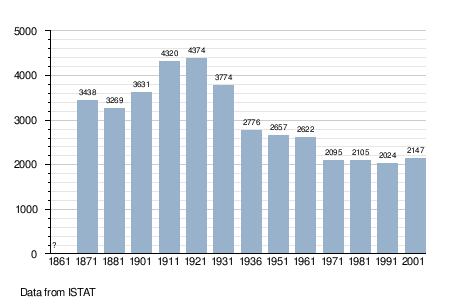
Demographic evolution
References
External links
This article is issued from Wikipedia - version of the 1/31/2015. The text is available under the Creative Commons Attribution/Share Alike but additional terms may apply for the media files.