Tammela, Finland
| Tammela | ||
|---|---|---|
| Municipality | ||
| Tammelan kunta | ||
|
Stone church of Tammela | ||
| ||
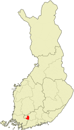 Location of Tammela in Finland | ||
| Coordinates: 60°48′N 023°46′E / 60.800°N 23.767°ECoordinates: 60°48′N 023°46′E / 60.800°N 23.767°E | ||
| Country | Finland | |
| Region | Tavastia Proper | |
| Sub-region | Forssa sub-region | |
| Charter | 1868 | |
| Government | ||
| • Municipality manager | Kalle Larsson | |
| • Density | 0/km2 (0/sq mi) | |
| Time zone | EET (UTC+2) | |
| • Summer (DST) | EEST (UTC+3) | |
| Website | www.tammela.fi | |


Tammela is a municipality of Finland. The first mention of a village named Tammela was in documents from 1423.
It is located in the province of Southern Finland and is part of the Tavastia Proper region. The municipality has a population of 6,271 (31 March 2016)[1] and it covers an area of 715.12 square kilometres (276.11 sq mi) of which 74.72 square kilometres (28.85 sq mi) is inland water (2011-01-01).[2] The population density is 10 inhabitants per square kilometre (26/sq mi) (31 March 2016).
The municipality is unilingually Finnish.
Tammela is also the name of a district in the city of Tampere.
Villages
Hevoniemi, Hykkilä, Häiviä, Kallio, Kankainen, Kaukjärvi, Kaukola, Kuuslammi, Kytö, Letku, Liesjärvi, Lunkaa, Mustiala, Myllykylä, Ojainen, Pappila, Patamo, Pikonkorpi, Porras, Riihivalkama, Saari, Sukula, Susikas, Taljala, Talpia, Tammela, Teuro, Torajärvi, Torro.
People born in Tammela
- Robert Wilhelm Lagerborg (1796 –1849)
- Toivo Alavirta (1890 – 1940)
- Rabbe Enckell (1903 – 1974)
- Eino Kujanpää (1904 – 1980)
- Antti Laaksonen (1972 –)
References
External links
 Media related to Tammela at Wikimedia Commons
- Municipality of Tammela – Official website (Finnish)
| Municipalities |  | |
|---|---|---|
| Former municipalities | ||