Tamuning, Guam
| Tamuning Tamuneng | |
|---|---|
| Village | |
 | |
 Location of Tamuning within the Territory of Guam. | |
| Country | United States |
| Territory | Guam |
| Government | |
| • Mayor | Louise C. Rivera (R) |
| • Vice Mayor | Kenneth C. Santos (R) |
| Population (2010)[1] | |
| • Total | 19,685 |
| Time zone | ChST (UTC+10) |
| Historical population | |||
|---|---|---|---|
| Census | Pop. | %± | |
| 1960 | 5,944 | — | |
| 1970 | 10,218 | 71.9% | |
| 1980 | 13,580 | 32.9% | |
| 1990 | 16,673 | 22.8% | |
| 2000 | 18,012 | 8.0% | |
| 2010 | 19,685 | 9.3% | |
| Source:[1] | |||
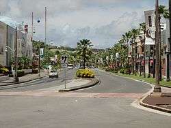
Tamuning, also known as Tamuning-Tumon-Harmon (Chamorro: Tamuneng) is a municipality or village located on the western shore of the United States territory of Guam. The village of Tamuning can be viewed as the economic center of Guam, containing Tumon (the center of Guam's tourist industry), Harmon Industrial Park, and commercial districts in other parts of the municipality. Its central location along Marine Corps Drive (the island's main thoroughfare) has aided in its development.
Tamuning is the site of the access roads and the old passenger terminal of Antonio B. Won Pat International Airport, the passenger airport for Guam.[2] Fort Juan Muña, in Harmon, is a facility for the Guam Army National Guard.
The present and former locations of Guam Memorial Hospital, Guam's only civilian and government operated hospital, are in Tamuning. With Guam's only private birthing center[3] also in the village, most modern civilian births on Guam take place in Tamuning.
Economy
Beside the tourist district of Tumon, Tamuning is home to the Guam Premier Outlets, one of three major shopping centers of the island. Continental Micronesia, a subsidiary of Continental Airlines, is headquartered in the old terminal building at Antonio B. Won Pat International Airport in Tamuning.[4][5] Continental Micronesia, with about 1,400 jobs, is Guam's largest single employer.[6]
Infrastructure and government
Government of Guam
The Guam Department of Land Management and the Guam Economic Development Authority have its headquarters in the Guam International Trade Center (ITC) Building in Tamuning.[7][8]
The Guam Power Authority has its headquarters in Harmon, Tamuning.[9]
The Guam Department of Mental Health and Substance Abuse has its main facility in Tamuning, across from Guam Memorial Hospital.[10][11]
U.S. federal government
The United States Postal Service operates the Tamuning Post Office at 143 Edward T. Calvo Memorial Parkway.[12]
Climate
| Climate data for Tamuning, Guam | |||||||||||||
|---|---|---|---|---|---|---|---|---|---|---|---|---|---|
| Month | Jan | Feb | Mar | Apr | May | Jun | Jul | Aug | Sep | Oct | Nov | Dec | Year |
| Average high °F (°C) | 85.1 (29.5) |
85.3 (29.6) |
86.1 (30.1) |
87.0 (30.6) |
87.4 (30.8) |
87.8 (31) |
87.2 (30.7) |
86.9 (30.5) |
86.9 (30.5) |
87.1 (30.6) |
86.8 (30.4) |
85.9 (29.9) |
86.6 (30.3) |
| Average low °F (°C) | 75.1 (23.9) |
74.6 (23.7) |
75.0 (23.9) |
76.2 (24.6) |
76.9 (24.9) |
77.1 (25.1) |
76.5 (24.7) |
76.2 (24.6) |
76.1 (24.5) |
76.4 (24.7) |
76.7 (24.8) |
76.1 (24.5) |
76.1 (24.5) |
| Average precipitation inches (mm) | 4.5 (114) |
3.5 (89) |
2.6 (66) |
3.3 (84) |
5.0 (127) |
6.3 (160) |
10.4 (264) |
14.4 (366) |
13.4 (340) |
12.2 (310) |
8.4 (213) |
5.5 (140) |
89.5 (2,273) |
| Source: Weatherbase [13] | |||||||||||||
Education
Primary and secondary schools
Public schools
Guam Public School System serves the island.
Public schools serving Tamuning:[14]
- Chief Brodie Memorial Elementary School (Tamuning)
- Lyndon B. Johnson Elementary School (Tamuning)
- Tamuning Elementary School (Tamuning)
- Jose L. G. Rios Middle School (Piti)
- John F. Kennedy High School (Tamuning)
Private schools
Diplomacy
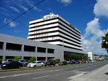
Five countries maintain consulates in Tamuning.[15] Except for the Korean consulate, the other four are all located in the landmark Guam ITC building at 590 South Marine Corps Drive.[16][17][18][19]
-
 F.S. Micronesia (Suite 613B, ITC Building)[16]
 -
 Japan (Suite 604A, ITC Building)[17]
 -
 Palau (Suite 615B, ITC Building)[18]
 -
 Philippines (Suite 601A, ITC Building)[19]
 -
 South Korea (125C Tun Jose Camacho Street)[20]
Mayor of Tamuning
Mayor
- Gregorio A. Calvo (1973–1985)
- Alfredo C. Dungca (1985–1997)
- Luis S.N. Herrero (1997–2001)
- Concepcion "Connie" Duenas (2001–2005)
- Francisco "Frank" C. Blas (2005–2013)
- Louise C. Rivera (2013–present)
Vice Mayor
- Maria S.N. Leon Guerrero (1973–1977)
- Alfredo C. Dungca (1977–1985)
- Peter S. Calvo (1985–1989)
- Teresita C. Borja (1989–1997)
- Concenpcion Duenas (1997–2001)
- Nancy Leon Guerrero (2001–2005)
- Louise C. Rivera (2005–2013)
- Kenneth Santos (2013–present)
Gallery
 Tamuning Fire Station
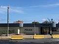 Sgt. Frankie E. Smith Police Station
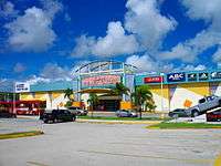

See also
References
- 1 2 "2010 Guam Statistical Yearbook" (PDF). (4.3 MB), (rev. 2011)
- ↑ "CBC66010_009.pdf." U.S. Census Bureau. Retrieved on October 6, 2010.
- ↑
- ↑ "Docket No. SDWA-06-2005-1516." United States Environmental Protection Agency. Retrieved on February 5, 2009.
- ↑ Letter. United States Department of Transportation Office of Aviation Enforcement and Proceedings. May 23, 1997. Retrieved on October 4, 2010. "Continental Micronesia Old Terminal Bldg. P.O. Box 8778-G Tamuning, GU 96931-8778."
- ↑ Kerrigan, Kevin. "Guam Will Be The Pacific Hub for Merged Airlines." Pacific News Center. Wednesday May 5, 2010. Retrieved on October 5, 2010. "Continental Micronesia is Guam's single largest employer. About 14-hundred jobs here on dependant on the airline."
- ↑ "DLM%20Contact%20Info.pdf." Guam Department of Land Management. Retrieved on October 21, 2010. "Street Address: 590 S. Marine Corps Drive Suite 733, ITC Building, Tamuning, GU 96913"
- ↑ http://www.investguam.com/
- ↑ "Grants and Resources." Environmental Protection Agency. Retrieved on October 13, 2010. "1911 Route 16 Harmon, GU 96911."
- ↑ "About DMHSA." Guam Department of Mental Health and Substance Abuse. Retrieved on October 21, 2010.
- ↑ "Facilities." Guam Department of Mental Health and Substance Abuse. Retrieved on October 21, 2010. "DMHSA Facility ( Click here to view Location Map ) Location : 790 Gov. Camacho Road, Tamuning, Guam 96913." Map.
- ↑ "Post Office Location - TAMUNING." United States Postal Service. Retrieved on December 4, 2008.
- ↑ "Weatherbase: Historical Weather for Tamuning, Guam". Weatherbase. 2011. Retrieved on November 24, 2011.
- ↑ http://web.archive.org/web/20060222192437/http://www.lk4kids.com/school+links.htm
- ↑ Guam Phone Book
- 1 2 "Federated States of Micronesia Consulates in the USA." Embassy of the Federated States of Micronesia, Washington, DC. Retrieved on December 4, 2008.
- 1 2 Home page. Consulate-General of Japan in Hagatna. Retrieved on December 4, 2008.
- 1 2 "Palau - U.S. Consulates and Overseas Missions." Embassy of the Republic of Palau, Washington, DC. Retrieved on December 4, 2008.
- 1 2 Home page. Consulate-General of the Philippines in Agana, Guam. Retrieved on December 4, 2008.
- ↑ "총영사관 소개." Embassy of the Republic of Korea in the United States of America. Retrieved on December 4, 2008.
External links
| Wikimedia Commons has media related to Tamuning, Guam. |
Hagåtña (capital) | |
| Topics | |
| Islands | |
| Villages | |
| Peaks |
|
Coordinates: 13°29′02″N 144°46′36″E / 13.48389°N 144.77667°E