Umatac, Guam
| Umatac Humåtak | |
|---|---|
| Village | |
 | |
 Location of Umatac within the Territory of Guam. | |
| Country | United States |
| Territory | Guam |
| Government | |
| • Mayor | Johnny A. Quinata (R) |
| Population (2010)[1] | |
| • Total | 782 |
| Time zone | ChST (UTC+10) |
Umatac (Chamorro: Humåtak), formerly called Umata, is a village on the southwestern coast of the United States territory of Guam. The month of March in the Chamorro language is "Umatalaf," or "to catch guatafi," which is believed to be the root word of Umatac.[2] The village's population has decreased since the island's 2000 census.[3]
Nearby (4.5 km) is Mount Bolanos (368 m or 1,207 ft), the 3rd highest peak of Guam.
History

| Historical population | |||
|---|---|---|---|
| Census | Pop. | %± | |
| 1960 | 744 | — | |
| 1970 | 813 | 9.3% | |
| 1980 | 732 | −10.0% | |
| 1990 | 897 | 22.5% | |
| 2000 | 887 | −1.1% | |
| 2010 | 782 | −11.8% | |
| Source:[1] | |||
Prior to Spanish arrival on the island, an annual celebration was held north of the village at Fouha Rock where the first humans were created according to the legends of the Chamorro people, the native people of Guam.
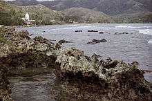
In 1521, the Portuguese Explorer Ferdinand Magellan arrived on Guam while circumnavigating the globe. Umatac Bay is traditionally cited as the location of the Spanish landing. Another explorer, Miguel López de Legazpi, arrived in Umatac in 1565 and claimed the island of Guam for Spain.
When Guam was colonized in the 17th century, the Spanish made Umatac a parish so the Chamorro people in the area could be converted to Christianity. Remains of two Spanish forts built on hills on either side of the village are still visible today.
In 1898, Guam was taken by the United States during the Spanish–American War. Under the U.S. administration, the small village has grown gradually. Today, the Discovery Day festival is held every year in the village. While the holiday was first established in memory of Magellan's discovery of the island, it is now a celebration of Chamorro culture.
Education
The Guam Department of Education serves the island. The F. Q. Sanchez Elementary School in Umatac has closed at the end of summer 2011 due to budget cuts. Students have shifted to a nearby Merizo Elementary School.[4] The unused facility was then cleared for use by the Umatac Mayor's Office.[5]
Southern High School in Santa Rita serves the village.[6]
Notable residents
- Senator Thomas "Tommy" Morrison
Mayor of Umatac
Commissioner
- Jesus T. Quinata (1961–1969)
- Jesus S. Quinata (1952–1961)
- Albert T. Topasna (1969–1973)
Mayor
- Albert T. Topasna (1st Term) (1973–1985)
- Cecilia Q. Morrison (1985–1989)
- Albert T. Topasna (2nd Term) (1989–1991)
- Dean D. Sanchez (1st Term) (1991–1993)
- Jose T. Quinata (1993–1997)
- Jesus A. Aquiningoc (1997–2001)
- Tony A. Quinata (2001–2005)
- Daniel Q. Sanchez (2005–2009)
- Dean D. Sanchez (2nd Term) (2009–2013)
- Johnny A. Quinata (2013–present)
See also
References
- 1 2 "2010 Guam Statistical Yearbook" (PDF). (4.3 MB), (rev. 2011)
- ↑ Sanchez, Anthony P. (April 27, 2005). "Guam's Umatac - Chamorro cradle of creation". Pacific Islands Report.
- ↑ Hart, Therese (August 26, 2011). "Guam Population slightly up, latest census says". Marianas Variety.
- ↑ Kelman, Brett (July 1, 2011). "Umatac School to Close". Pacific Daily News.
- ↑ "NEWS: Facility Handed Over to the People of Umatac".
- ↑ "Guam's Public High Schools." Guam Public School System. Accessed September 8, 2008.
- Rogers, Robert F (1995). Destiny's Landfall: A History of Guam: University of Hawai'i Press. ISBN 0-8248-1678-1
- Sanchez, Pedro C. Guahan, Guam: The History of our Island: Sanchez Publishing House.
External links
| Wikimedia Commons has media related to Umatac, Guam. |
- "Umatac (Humåtak)" - article on Guampedia.com
- "Umatac - Guam's Cradle of Creation" by Anthony P. Sanchez, Pacific Daily News, 26 April 2007
- Village Map, Pacific Daily News
- "Municipalities of Guam". Statoids.
Hagåtña (capital) | |
| Topics | |
| Islands | |
| Villages | |
| Peaks |
|
Coordinates: 13°17′53″N 144°39′32″E / 13.29806°N 144.65889°E