Tatra Mountains
| Tatra Mountains | |
|---|---|
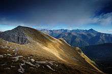
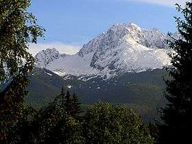
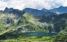
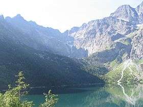 View from above Morske Oko | |
| Highest point | |
| Peak | Gerlachovský štít |
| Elevation | 2,655 m (8,711 ft) |
| Geography | |
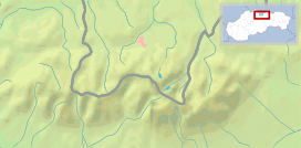 | |
| Countries | Slovakia and Poland |
| Range coordinates | 49°10′N 20°08′E / 49.17°N 20.13°ECoordinates: 49°10′N 20°08′E / 49.17°N 20.13°E |
| Parent range | Western Carpathians |
The Tatra Mountains, Tatras or Tatra (Tatry either in Slovak (pronounced [ˈtatri]) or in Polish (pronounced [ˈtatrɨ])- plurale tantum), are a mountain range that form a natural border between Slovakia and Poland. They are the highest mountain range in the Carpathian Mountains. The Tatras should be distinguished from the Low Tatras (Slovak: Nízke Tatry) which are located south of the Tatra Mountains in Slovakia.
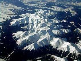
The Tatra Mountains occupy an area of 785 square kilometres (303 sq mi), of which about 610 square kilometres (236 sq mi) (77.7%) lie within Slovakia and about 175 square kilometres (68 sq mi) (22.3%) on the territory of Poland. The highest peak, called Gerlach, at 2,655 m (8710 ft) is located north of Poprad. The highest point in Poland, Rysy, at 2,499 m (8200 ft) is located south of Zakopane.[1][2]
The Tatras' length, measured from the eastern foothills of the Kobyli Wierch (1109 m) to the southwestern foot of Ostry Wierch Kwaczański (1128 m), in a straight line is 57 km (35 mi) (or 53 km (33 mi) according to some),[2] and strictly along the main ridge, 80 km (50 mi). The range is only 19 km (12 mi) wide.[3] The Tatras' main ridge leads from Huciańska Pass (905 m) in the west to Zdziarska Pass (1081 m) to the east.
The Tatras are protected by law by the establishment of the Tatra National Park, Slovakia and the Tatra National Park, Poland, which are jointly entered in UNESCO's World Network of Biosphere Reserves. In 1992 the Polish and Slovak parks were jointly designated a transboundary biosphere reserve by UNESCO in the World Network of Biosphere Reserves under its Man and the Biosphere Programme.[4]
Overview
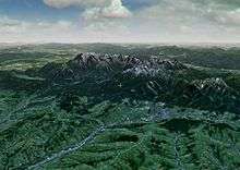
The Tatras are a mountain range of a corrugated nature, originating from the Alpine orogeny, and therefore characterized by a relatively young-looking lay of the land, quite similar to the landscape of the Alps, although significantly smaller. It is the highest mountain range within Carpathians. It consists of the internal mountain chains of:
- Western Tatras (Slovak: Západné Tatry, Polish: Tatry Zachodnie)
- Eastern Tatras (Východné Tatry, Tatry Wschodnie), which in turn consist of:
- the High Tatras (Vysoké Tatry, Tatry Wysokie)
- and Belianske Tatras (Belianske Tatry, Tatry Bielskie)
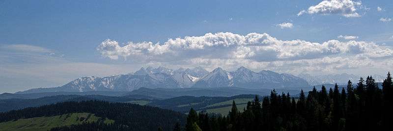
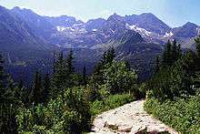
The overall nature of the Tatras, together with their easy accessibility, makes them a favorite with tourists and researchers. Therefore, these mountains are a popular winter sports area, with resorts such as Poprad and the town Vysoké Tatry (The Town of High Tatras) in Slovakia created in 1999, including former separate resorts: Štrbské Pleso, Starý Smokovec, and Tatranská Lomnica or Zakopane, called also "winter capital of Poland". The High Tatras, with their 24 (or 25) peaks exceeding 2,500 m above sea level, together with the Southern Carpathians, represent the only form of alpine landscape in the entire 1,200 kilometres (746 miles) length of arc of the Carpathians.
Memberships and border
By the end of the First Polish Republic and the Polish border between the Kingdom of Hungary in the Tatras was not strictly defined. The Tatras became an unoccupied borderland. On November 20, 1770, under the guise of protection against the epidemic of plague in the Podolia, an Austrian army entered into Polish land and formed a cordon sanitaire, seizing Sądecczyzna, Spiš and Podhale. Two years later, the First Partition of Poland allocated the lands to Austria. In 1824, Zakopane good and Fish Creek Valley with Morskie Oko purchased from the authorities of the Austrian Hungarian Emanuel Homolacs. In 1867 formed the Austria-Hungary and the Tatra Mountains have become imaginary border between the two states of the monarchy, but the border itself still has not been exactly determined. In 1889, Count Władysław Zamoyski purchased at auction a good Zakopane (Zakopane and the Tatra Mountains, along with part of Morskie Oko). Due to numerous disputes over lands belonging in the late nineteenth century, attempts were made to the delimitation of the border. They did not bring effect in 1897, and the case went to an international court that on September 13, 1902 determined the exact course of the Austria-Hungary border in the disputed area.
Climate
The Tatras lie in the temperate zone of Central Europe. They are an important barrier to the movements of air masses. Their mountainous topography causes one of the most diverse climates in that region.
- Winds
The average wind speed on the summits is 6 m/s.
- southerly winds on the northern side
- westerly winds at the base of Tatra (Orava-Nowy Targ Basin)
- foehn winds (Polish: halny) most often occur between October and May. They are warm and dry and can cause extensive damage.
- Maximum wind speed 288 km/h (179 mph) (6 May 1968).[5]
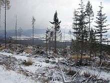
On 19 November 2004, large parts of the forests in the southern Slovak part of the High Tatras were damaged by a strong wind storm.[5] Three million cubic metres of trees were uprooted, two people died and several villages were totally cut off. Further damage was done by a subsequent forest fire, and it will take many years until the local ecology is fully recovered.
- Temperature
Temperatures range from −40 °C (−40 °F) in the winter to 33 °C (91 °F) in warmer months. Temperatures also vary depending on altitude and sun exposure of a given slope. Temperatures below 0 °C (32 °F) last for 192 days on the summits.
- Precipitation
Highest precipitation figures are recorded on the northern slopes. In June and July monthly precipitation reaches around 250 mm (10 in). Precipitation occurs from 215 to 228 days a year. Thunderstorms occur 36 days a year on average.
- Snow cover
Maximum thickness on the summit amounts to:
- in Slovakia - Lomnický Štít: 410 cm (161 in)
- in Poland - Kasprowy Wierch: 355 cm (140 in)
Peaks are sometimes covered with snow or ice throughout the year. Avalanches are frequent.
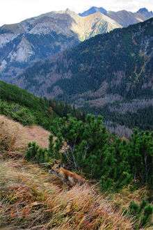
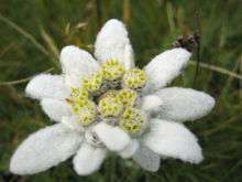
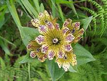
Flora
The Tatra Mountains have a diverse variety of plant life. They are home to more than 1,000 species of vascular plants, about 450 mosses, 200 liverworts, 700 lichens, 900 fungi, and 70 slime moulds. There are five climatic-vegetation belts in the Tatras.
The distribution of plants depends on altitude:
- up to 1,300 m: Carpathian beech forest; almost no shrub layer, herbaceous layer occupies most of the forest floor
- to 1,550 m: Spruce forest; shrub layer poorly developed, mosses are a major component
- to 1,800 m: Mountain Pine, numerous herbs
- to 2,300 m: high altitude grasslands
- from 2,300 m up: Subnivean - bare rock and almost no vegetation (mostly lichens)
Fauna
The Tatra Mountains are home to many species of animals: 54 tardigrades, 22 turbellarians, 100 rotifers, 22 copepods, 162 spiders, 81 molluscs, 43 mammals, 200 birds, 7 amphibians and 2 reptiles.
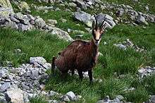
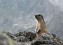
The most notable mammals are the Tatra chamois, marmot, snow vole, brown bear, wolf, Eurasian lynx, red deer, roe deer, and wild boar. Notable fish include the brown trout and alpine bullhead.
The endemic arthropod species include a caddis fly, spider Xysticus alpicola[6] and a springtail.
Summits
- Eastern Tatras
- Gerlachovský štít - 2655 m (Slovakia)
- Lomnický štít - 2634 m (Slovakia)
- Ľadový štít - 2627 m (Slovakia)
- Pyšný štít - 2621 m (Slovakia)
- Zadný Gerlach - 2616 m (Slovakia)
- Lavínový štít - 2606 m (Slovakia)
- Ľadová kopa - 2602 m (Slovakia)
- Kotlový štít - 2601 m (Slovakia)
- Malý Pyšný štít - 2592 m (Slovakia)
- Kežmarský štít - 2558 m (Slovakia)
- Vysoká - 2547 m (Slovakia)
- Končistá - 2538 m (Slovakia)
- Baranie rohy - 2526 m (Slovakia)
- Dračí štít - 2523 m (Slovakia)
- Ťažký štít - 2520 m (Slovakia)
- Malý Kežmarský štít - 2513 m (Slovakia)
- Rysy - 2503 m, 2499 m (Slovakia/Poland)
- Kriváň - 2495 m (Slovakia)
- Slavkovský štít - 2452 m (Slovakia)
- Batizovský štít - 2448 m (Slovakia)
- Veľký Mengusovský štít (Slovak); Mięguszowiecki Szczyt Wielki (Polish) - 2438 m (Slovakia/Poland)
- Malé Rysy (Slovak); Niżnie Rysy (Polish) - 2430 m (Slovakia/Poland)
- Východný Mengusovský štít (Slovak); Mięguszowiecki Szczyt Czarny (Polish) - 2410 m (Slovakia/Poland)
- Prostredný Mengusovský štít (Slovak); Mięguszowiecki Szczyt Pośredni (Polish) - 2393 m (Slovakia/Poland)
- Čubrina (Slovak); Cubryna (Polish) - 2376 m (Slovakia/Poland)
- Svinica (Slovak); Świnica (Polish) - 2301 m (Slovakia/Poland)
- Kozi Wierch - 2291 m (Poland)
- Zamarła Turnia - 2179 m (Poland)
- Kościelec - 2155 m (Poland)
- Mnich - 2068 m (Poland)
- Western Tatras
- Bystrá - 2248 m (Slovakia)
- Jakubina - 2194 m (Slovakia)
- Baranec - 2184 m (Slovakia)
- Baníkov - 2178 m (Slovakia)
- Klin (Slovak); Starorobociański Wierch (Polish) - 2176 m (Slovakia/Poland)
- Pachoľa - 2167 m (Slovakia)
- Hrubá kopa - 2166 m (Slovakia)
- Nižná Bystrá - 2163 m (Slovakia)
- Štrbavy - 2149 m (Slovakia)
- Jalovecký príslop - 2142 m (Slovakia)
- Hrubý vrch (Slovak); Jarząbczy Wierch (Polish) - 2137 m (Slovakia/Poland)
- Tri kopy - 2136 m (Slovakia)
- Veľká Kamenistá (Slovak); Kamienista (Polish) - 2126 m (Slovakia/Poland)
- Krzesanica - 2122 m (Slovakia/Poland) - summit of Czerwone Wierchy / Red Mountains
- Volovec (Slovak); Wołowiec (Polish) - 2064 m (Slovakia/Poland)
- Kasprov vrch (Slovak); Kasprowy Wierch (Polish) - 1987 m (Slovakia/Poland)
- Giewont - 1894 m (Poland)
- Sivý vrch - 1809 m (Slovakia)
Trails
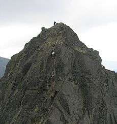
Orla Perć is considered the most difficult and dangerous public path in the entire Tatras, a suitable destination only for experienced tourists and climbers. It lies exclusively within the Polish part of the Tatras and was conceived in 1901 by Franciszek Nowicki, a Polish poet and mountain guide. More than one hundred individuals have lost their lives on the route since it was first established. The path is marked with red signs.
The highest point in the Tatra Mountains with access by labeled trails is Rysy.
Human engagement
In the 18th and 19th centuries, the mountains were used for sheep grazing and mining. Many trees were cut down to make way for humans. Although these activities were stopped, the impact is still visible. Moreover, pollution from the industrialized regions of Kraków in Poland or Ostrava in Czech Republic, as well as casual tourism, cause substantial damage.[7] Volunteers however initiate litter removal events frequently, on both sides of the border.
The Slovak Tatra National Park (Tatranský národný park; TANAP) was founded in 1949 (738 km2, 285 sq mi), and the contiguous Polish Tatra National Park (Tatrzański Park Narodowy) in 1954 (215.56 km2, 83.23 sq mi).[8] The two parks were added jointly to the UNESCO Biosphere Reserve list in 1993.[4]
In 2013 the International Union for Conservation of Nature threatened to cancel the Slovak TANAP's status of a national park because of the large investments (mainly in skiing infrastructure) in the park, which seriously interfere with the landscape and nature.
The 1999 film Ravenous was filmed in the Tatra Mountains.[9]
In 2006, the Bollywood film Fanaa, portraying places in Kashmir, was filmed at Zakopane, mainly because of the risks associated with insurgency in Kashmir, as well due to some similarities in a mountain landscape.
Notable people
- Jan Nepomucen Głowacki, considered the father of Polish school of landscape painting, was the first to devote an entire series of works to Tatra Mountains
- Daniel Speer, Baroque composer and writer
- Stanisław Staszic
- Ludwig Greiner identified Gerlachovský Peak as the summit of the Tatras and Carpathians
- Seweryn Goszczyński, Polish Romantic poet who escaped there from the Austrian invader
- Ludwik Zejszner
- Tytus Chałubiński, founder of the Polish Tatra Society
- Adam Asnyk, poet and dramatist, one of the first members of the Tatra Society
- Walery Eljasz-Radzikowski
- Stanisław Witkiewicz
- Władysław Zamoyski
- Oswald Balzer
- Jan Kasprowicz
- Franciszek Nowicki
- Kazimierz Przerwa-Tetmajer
- Mariusz Zaruski
- Mieczysław Karłowicz
- Władysław Orkan
- Karol Szymanowski
- Mieczysław Szczuka
- Kornel Makuszyński
- Ruth Hale (alpinist)
- Władysław Hasior
- Jan Długosz (mountaineer)
- William Horwood's novel Wolves of Time largely takes place in the Tatra mountains
- Göran Wahlenberg
Rankings
- Polish Tatra National Park on the 12th place in the ranking of CNN[10]
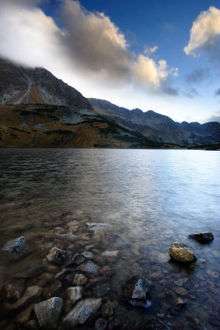
- The Wall Street Journal recognized Morskie Oko for one of the five most beautiful lakes in the world[11]
See also
References
- ↑ Mark Trengove (July 2005). "Introduction to the Tatras". Mountains of the World. PeakList. Retrieved January 1, 2013.
- 1 2 Marek Strzala (2012). "Tatra Mountains. Features. Weather. Wildlife". National parks. Krakow Info. Retrieved January 1, 2013.
- ↑ Maciek Krupa (2012). "The Tatra Mountains and Tatra National Park". Discover Zakopane. BAW Altius. Retrieved January 1, 2013.
- 1 2 "Europe & North America: 297 biosphere reserves in 36 countries". Ecological Sciences for Sustainable Development. Archived from the original on 2015-08-05. Retrieved 2016-01-31.
- 1 2 Igor J. Zaleski, Tomasz Mączka. "Wiatr halny (foehn wind)" (in Polish). www.tpn.pl.
- ↑ "Kulczynski, 1882, Fauna Europaea: Xysticus alpicola". Fauna Europaea version 2.4, www.faunaeur.org.
- ↑ lter-europe.net. "Multi-scale interactions between disturbances and ecological and socioeconomical changes – case study High Tatra Mts. (Slovakia)" (PDF). Retrieved 14 June 2015.
- ↑ "Official website of Polish Tatra National Park" (in Polish). www.tpn.pl.
- ↑ "Ravenous filming locations". imdb.com.
- ↑ "Tatrzański Park Narodowy na 12. miejscu w rankingu CNN" (in Polish). onet. Retrieved 2015-04-11.
- ↑ Great Lakes Around the World
Bibliography
- Lacika, Ján (2006). Tatras (2nd ed.). Bratislava. ISBN 80-88975-95-6.
- Saunders, Colin; Nárožná, Renáta (2006). Walking in the High Tatras (2nd ed.). Cicerone Press (Milnthorpe). ISBN 9781852844820.
External links
| Wikimedia Commons has media related to Tatra Mountains. |
- Places to visit Tatras Mountains – (available in: ENG)
- Town of Vysoké Tatry – municipal website (available in: ENG, SLV)
- Zakopane – municipal website (available in: POL, ENG)
- TANAP – Slovak Tatra National Park (available in: SLV, ENG, POL)
- TPN – Polish Tatra National Park (available in POL only)
- Commercial tourism-oriented websites
- The High Tatras - Accommodation and Tourism (available in: SLV, CZE, POL, ENG, GER)
- Vysoké Tatry, Slovakia (available in: ENG, GER, SLV, POL)
- Tatry - The smallest mountains in the biggest detail. (available in: ENG, CZE)
- Page about Zakopane (available in: POL, ENG)
- Tatra auf Travelia.sk
- Mountaineering
- Tatra Volunteer Rescue Service (available in POL only)
- Mountaineering in Tatra Mountains (practical info about climbing in Tatras)
- Photography
- K2 Studio - photographs of the Tatras (available in: SLV, ENG)
- 360 - a spherical panoramic journey in 1583 pieces (available in: POL, ENG)
- CinemaPhoto.pl - photographs in Tatras (available in: POL, ENG)
- Astonishing Vintage Images of the Tatra Mountains
- Films