Texas State Highway 332
| ||||
|---|---|---|---|---|
 | ||||
| Route information | ||||
| Maintained by TxDOT | ||||
| Length: |
15.646 mi[1] (25.180 km) Total length of 20.4 mi (32.8 km) includes a 4.8 mi (7.7 km) concurrent section with SH 288 | |||
| Existed: | 1956 – present | |||
| Major junctions | ||||
| West end: |
| |||
| East end: | Bluewater Highway in Surfside Beach | |||
| Highway system | ||||
| ||||

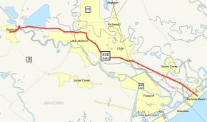
State Highway 332, abbreviated SH 332, is a 15.646-mile (25.180 km) state highway in the U.S. state of Texas. The highway includes a 4.8 mi (7.7 km) concurrent section with SH 288 that brings the total length to 20.4 miles (32.8 km). The highway begins at a junction with State Highway 36 (SH 36) in Brazoria and heads east to a junction with the Bluewater Highway in Surfside Beach.
History
SH 332 was originally designated in 1939 as the bridge over the Intercoastal Canal. In 1950, it was redesignated and combined with FM 1460 which had been designated a year earlier to from the bridge to FM 523. In 1954, the eastern terminus was extended to an intersection with the Bluewater Highway, while the western terminus was extended to FM 521 when FM 1605 was combined with the route. In 1956, the route was redesignated to SH 332 and the western end was extended to SH 36 replacing FM 521.[1][2]
Route description
SH 332 begins at a junction with SH 36 in Brazoria. It heads east from this junction to an intersection with FM 521. The highway continues to the east to an intersection with FM 2004 in Lake Jackson. Heading towards the east, the highway continues to an intersection SH 288. The highway intersects SH 288. It continues to the east to a junction with Business 288 in Clute. As the highway continues to the east, it intersects FM 523. SH 332 reaches its eastern terminus at the Bluewater Highway in Surfside Beach.[1][3]
Junction list
The entire route is in Brazoria County. All exits are unnumbered.
| Location | mi | km | Destinations | Notes | |
|---|---|---|---|---|---|
| Brazoria | 0.0 | 0.0 | West end of FM 521 overlap; FM 521 continues along SH 36 south | ||
| Bridge over Brazos River | |||||
| 1.4 | 2.3 | Interchange; no eastbound entrance; east end of FM 521 overlap | |||
| Lake Jackson | 6.5 | 10.5 | |||
| 7.6 | 12.2 | West end of SH 288 overlap | |||
| 8.4 | 13.5 | Interchange; westbound exit for This Way and West Way, access to Brazosport Memorial Hospital | |||
| 9.8 | 15.8 | Plantation Drive | Interchange | ||
| Clute | 11.0 | 17.7 | Dixie Drive | Interchange | |
| 12.0 | 19.3 | Main Street / Contractor Road / Copper Road | Interchange | ||
| 13.0 | 20.9 | Interchange; east end of SH 288 overlap | |||
| Freeport | 16.5 | 26.6 | |||
| Bridge over Gulf Intracoastal Waterway | |||||
| Surfside Beach | 20.4 | 32.8 | Fort Velasco Drive / Bluewater Highway / County Road 257 – Galveston | Leads to Galveston via the San Luis Pass toll bridge | |
1.000 mi = 1.609 km; 1.000 km = 0.621 mi
| |||||
References
- 1 2 3 Transportation Planning and Programming Division (n.d.). "State Highway No. 332". Highway Designation Files. Texas Department of Transportation. Retrieved 2008-03-31.
- ↑ Transportation Planning and Programming Division (n.d.). "Farm to Market Road No. 1460". Highway Designation Files. Texas Department of Transportation. Retrieved 2008-03-31.
- ↑ Google (2008-03-31). "overview map of SH 332" (Map). Google Maps. Google. Retrieved 2008-03-31.