Texas State Highway 96
| ||||
|---|---|---|---|---|
| League City Parkway | ||||
 | ||||
| Route information | ||||
| Maintained by TxDOT | ||||
| Length: | 6.45 mi[1] (10.38 km) | |||
| Existed: | 1994 – present | |||
| Major junctions | ||||
| West end: |
| |||
|
| ||||
| East end: |
| |||
| Location | ||||
| Counties: | Galveston | |||
| Highway system | ||||
| ||||

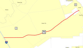
State Highway 96 (SH 96), also known as League City Parkway, is a state highway in the U.S. state of Texas. The highway runs approximately 6.5 miles (10.5 km) between Interstate 45 and SH 146 in Galveston County, connecting the cities of League City and Kemah.[2]
Route description
SH 96 begins in League City at I-45, just south of the Harris County line. From here, the highway travels to the east, crossing SH 3. It then passes over the Union Pacific Railroad line and has an incomplete interchange with the parallel Dickinson Avenue; access to the street is available from westbound SH 96 only, while traffic on the street can enter only eastbound SH 96. The route then crosses FM 270 before turning to the northeast, passing the site of the former Houston Gulf Airport. After intersections with several other surface streets, including the Columbia Memorial Parkway, SH 96 ends at SH 146 at the city line between League City and Kemah.[2]
History
SH 96 was designated along its current route in 1994.[1]
The SH 96 designation was previously used on a route from Raymondville to Harlingen, mainly along the Gulf Coast, beginning in 1926. By 1933, it was extended north to Corpus Christi. The route was truncated to Sinton by 1939, with an already-constructed section between Corpus Christi and Chapman Ranch transferred to SH 286. The remaining route was redesignated as U.S. Highway 77 in 1945 when that route was extended south.[1]
A section of FM 1266 shared a concurrency with SH 96, providing access to FM 646 to the south and FM 518 to the north. This concurrency was removed in 2003 when sections of FM 1266 within League City were returned to the city's jurisdiction.[3]
Major intersections
The entire route is in Galveston County.
| Location | mi | km | Destinations | Notes | |
|---|---|---|---|---|---|
| League City | I-45 exit 22; western terminus. | ||||
| W. Walker St. | |||||
| Dickinson Ave. | Interchange; westbound exit and eastbound entrance | ||||
| Louisiana Ave. | |||||
| Tuscan Lakes Blvd. | Former west end of FM 1266[3] concurrency | ||||
| S. Shore Blvd. | |||||
| Columbia Memorial Pkwy. | Former east end of FM 1266[3] concurrency | ||||
| Lawrence Rd. | |||||
| Kemah | Eastern terminus; at Kemah–League City city line | ||||
| 1.000 mi = 1.609 km; 1.000 km = 0.621 mi | |||||
References
- 1 2 3 Transportation Planning and Programming Division (n.d.). "State Highway No. 96". Highway Designation Files. Texas Department of Transportation. Retrieved November 19, 2008.
- 1 2 Transportation Planning and Programming Division (2012). Texas County Map Book (PDF) (Map) (2012 ed.). 1:120,000. Texas Department of Transportation. p. 583. OCLC 867856197. Retrieved February 1, 2014.
- 1 2 3 Transportation Planning and Programming Division (n.d.). "Urban Road No. 1266". Highway Designation Files. Texas Department of Transportation. Retrieved February 1, 2014.